-
 Robert Wilkinson, Six Chrono-Genealogical Charts of Biblical History, 1842£ 240
 -
Robert Wilkinson, The Heart of the Roman Empire, 1842£ 125.00
-
Robert Wilkinson, The Empire of Charlemagne, 1842£ 95.00
-
Robert Wilkinson, Ancient Anatolia, 1842£ 85.00
-
Robert Wilkinson, Syria and Assyria, 1842£ 85.00
-
Robert Wilkinson, The March of the Ten Thousand Greeks, 1842£ 135.00
-
-
Robert Wilkinson, King Solomon's Twelve Purveyors, 1842£ 85.00
-
Robert Wilkinson, Parthian Empire, 1842£ 125.00
-
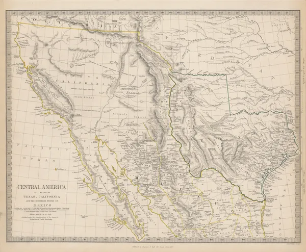
Central America II. Including Texas, California and the Northern States of Mexico, 1842Society for the Diffusion of Useful Knowledge (SDUK)Series: LondonSociety for the Diffusion of Useful Knowledge (SDUK), Central America II. Including Texas, California and the Northern States of Mexico, 1842£ 775.00
-
Robert Wilkinson, Canaan from the Time of Joshua to the Babylonish Captivity, 1842£ 195.00
-
Robert Wilkinson, The Route of St. Paul, 1842£ 125.00
-
French Admiralty, Chart of the Gulf of Mexico, 1843£ 885.00
-
British Admiralty, France South Coast: Port Vendre, 1843£ 50.00
-
Charles Frederick Cheffins, Map of the English and Scottish Railways, 1843£ 475.00
-
Otranto to Monopoli in Italy and Ragusa to Port Palermo in Albania, 1843British AdmiraltySeries: LondonBritish Admiralty, Otranto to Monopoli in Italy and Ragusa to Port Palermo in Albania, 1843£ 185.00
-
James Hall, Geological Map of the Middle and Western States, 1843£ 1,250.00
-
W. & A.K. Johnston, United States and Texas, 1843£ 1,150.00
-
Society for the Diffusion of Useful Knowledge (SDUK), Ancient Britain, 1843£ 95.00
-
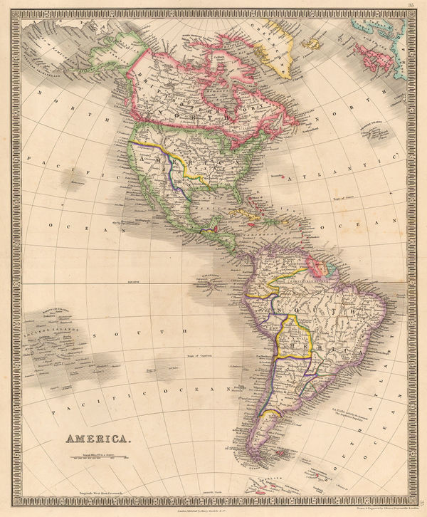
John Arrowsmith, America, 1844£ 1,950.00
-
-
Society for the Diffusion of Useful Knowledge (SDUK), Ancient Rome, 1844£ 325.00
-
Ashford & Loader, Map and Sections of the Staffordshire Coal Field, 1845£ 125.00
-
Map of the Railways Showing the Various Stations with the Hills, Rivers, Canals and Principal Roads of England and Wales, 1845Aaron ArrowsmithSeries: LondonAaron Arrowsmith, Map of the Railways Showing the Various Stations with the Hills, Rivers, Canals and Principal Roads of England and Wales, 1845£ 2,450.00
-
James Wyld, Post Map of Europe, 1845£ 450.00
-
James Wyld, Railway Map of England Wales and Scotland, 1845£ 1,850.00
-
Ashford & Loader, The Heights of the Mountains of the Eastern Hemisphere, 1845£ 975.00
-
William Hutcheon Hall, East coast of China from Canton to Nanking , 1845£ 345.00
-
-
Carl Flemming, Republic of Texas, 1845 c£ 1,850.00
-
Henry Teesdale, America, 1845 c.£ 445.00
-
Edward Wallis, European Travellers - An Instructive Game, 1845 c.£ 4,950.00
-
-
Joseph Meyer, Texas, 1846£ 2,650.00
-
James Reynolds, Waterfalls, 1846 c.£ 545.00
-
W. & A.K. Johnston, Physical Chart of the Indian Ocean, 1848£ 295.00
-
W. & A.K. Johnston, Zoological Geography - Ruminants & Rodents, 1848£ 595.00
-
W. & A.K. Johnston, Zoological Geography - Monkeys, Marsupials & Pachyderms, 1848£ 595.00
-
W. & A.K. Johnston, Zoological Geography - Carnivores, 1848£ 595.00
-
W. & A.K. Johnston, Zoological Geography - Birds, 1848£ 595.00
-
W. & A.K. Johnston, Botanical Geography - Food Crops & Edible Plants, 1848£ 495.00
-
W. & A.K. Johnston, Geological Phenomena, 1848£ 395.00
-
W. & A.K. Johnston, Illustrations of the Glacier Systems of the Alps, 1848£ 425.00
-
British Admiralty, Chart of the North Polar Sea, 1849£ 950.00
-
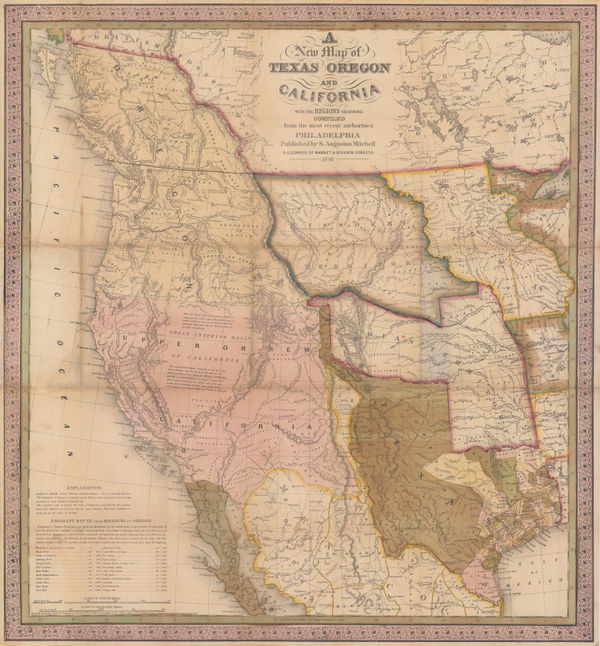
Samuel Augustus Mitchell, Map of Texas from the Most Recent Authorities, 1849£ 1,895.00
-
Ferdinand Schroders, German caricature of central Europe, 1849£ 950.00
-
James Wyld, Sketch of the Battle of Chilleanwala, 1849£ 2,500.00
-
James Reynolds, Geological map of England, 1849£ 545.00
-
General Chart - Farallones Entrance to the Bay of San Francisco, 1850Cadwalader RinggoldSeries: Washington, D.C.Cadwalader Ringgold, General Chart - Farallones Entrance to the Bay of San Francisco, 1850£ 1,950.00
-
James Reynolds, Geological Map of the World, 1850 c£ 545.00
-
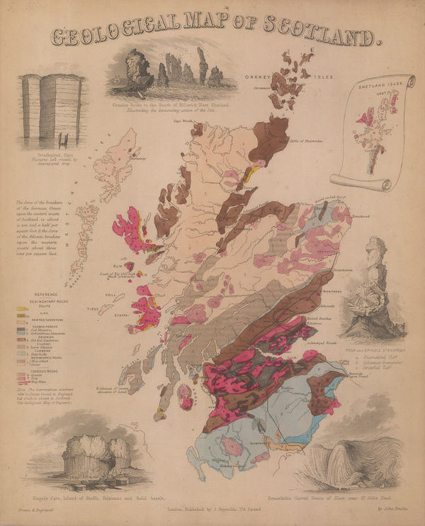
James Reynolds, Geological map of Scotland, 1850 c£ 545.00
-
Wallis's Picturesque Round Game of the Produce and Manufactures of the Counties of England and Wales, 1850 c.Edward WallisSeries: LondonEdward Wallis, Wallis's Picturesque Round Game of the Produce and Manufactures of the Counties of England and Wales, 1850 c.£ 1,250.00
-
John Tallis, Tallis's Railway Map of Great Britain, 1851£ 475.00
-
Andriveau-Goujon, Mediterranean Steamship Routes, 1851£ 650.00
-
French Admiralty, Chart of False Bay, 1852£ 475.00
-
Royal Geographical Society (RGS), Ruins of Ancient Milos, 1852£ 88.00
-
William Spooner, The Travellers of Europe Game, 1852£ 850.00
-
Edward Hitchcock, A Geological Map of the United States and Canada, 1853£ 985.00
-
British Admiralty, Chart of the Black Sea, 1853£ 875.00
-
Joseph Meyer, Geological Map of the United States, 1853£ 475.00
-
British Admiralty, Balaklava Bay, 1854£ 325.00
-
British Admiralty, Baltic Sea, 1854£ 985.00
-
British Admiralty, Chart of the coast of Costa Rica, 1854£ 200.00
-
-
James Wyld, Baltic Sea, 1854£ 985.00
-
Alexander Dallas Bache, Preliminary Chart of Plymouth Harbor, 1854£ 125.00
-
Geological Map of the Mississippi River to the Pacific Ocean, 1855United States Pacific Railroad Expeditions (USPRR)Series: Washington, D.C.United States Pacific Railroad Expeditions (USPRR), Geological Map of the Mississippi River to the Pacific Ocean, 1855£ 775.00
-
Geological Section from the Mississippi River to the Pacific Ocean, 1855United States Pacific Railroad Expeditions (USPRR)Series: Washington, D.C.United States Pacific Railroad Expeditions (USPRR), Geological Section from the Mississippi River to the Pacific Ocean, 1855£ 675.00
-
Sir Archibald Alison, Siege of Saragossa, 1855£ 75.00
-
Sir Archibald Alison, Siege of St. Jean d'Acre, 1855£ 65.00
-
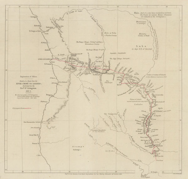
Royal Geographical Society (RGS), Livingstone's route from Botswana to Angola, 1855£ 225.00
-
British Admiralty, St. Petersburg Bay, 1855£ 675.00
-
Sir Archibald Alison, Lines of Torres Vedras, 1855£ 72.00
-
Sir Archibald Alison, Battle of Malo-Jaroslawitz, 1855£ 58.00
-
Sir Archibald Alison, Battle of Camperdown, 1855£ 115.00
-
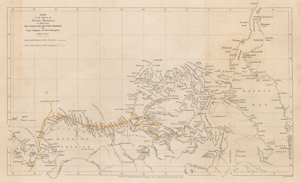
The Northwest Passage and the Search for Sir John Franklin, 1855Royal Geographical Society (RGS)Series: LondonRoyal Geographical Society (RGS), The Northwest Passage and the Search for Sir John Franklin, 1855£ 395.00
-
Sir Archibald Alison, Battle of Wagram, 1855£ 95.00
-
Justus Perthes, Geological Map of India, 1855£ 145.00
-
W. & A.K. Johnston, Geological Map of the World, 1855£ 750.00
-
William P. Blake, Geological Map of California, 1855£ 795.00


Page
5
of 15