-
 Sir Archibald Alison, Battle of Cape St. Vincent, 1855£ 225.00
 -
Sir Archibald Alison, Battle of Wavre, 1855£ 68.00
-
Edward Quin, A.D. 1660. At the Restoration of the Stuarts, 1856£ 385.00
-
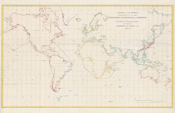
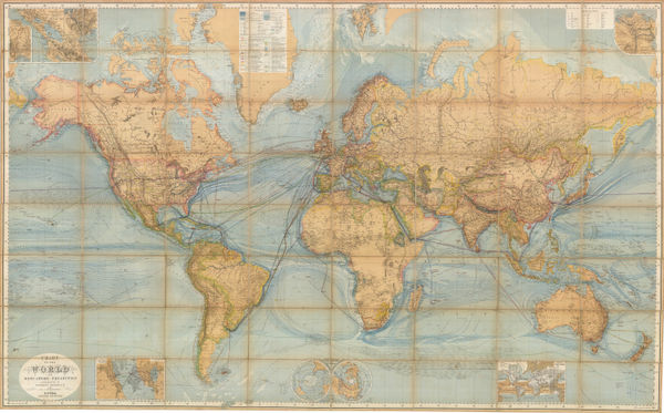
Matthew Perry, Chart of the World, 1856£ 950.00
-
W. & A.K. Johnston, Geological Map of Europe, 1856£ 3,500.00
-
-
Edward Quin, A.D. 476. The Dissolution of the Western Empire, 1856 c.£ 125.00
-
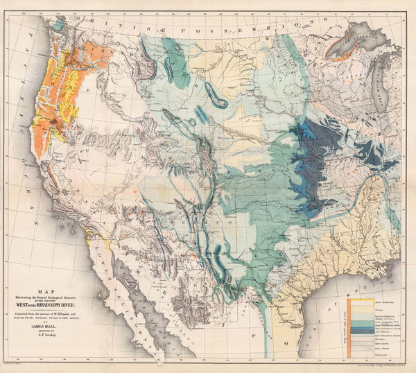
Map Illustrating the General Geological features of the Country West of the Mississippi River, 1857James HallSeries: Washington, D.C.James Hall, Map Illustrating the General Geological features of the Country West of the Mississippi River, 1857£ 1,350.00
-
Hansard, Railway and Cotton District Map of India, 1857£ 950.00
-
Royal Geographical Society (RGS), Sketch of the Battle of Marathon, 1857£ 98.00
-
George Frederick Cruchley, India during the Mutinies, 1857£ 3,750.00
-
Der Warme Meeresstrom des Atlantischen und Der Kalte Strom des Grossen Oceans, 1858Carl Christian Franz RadefeldSeries: HildburghausenCarl Christian Franz Radefeld, Der Warme Meeresstrom des Atlantischen und Der Kalte Strom des Grossen Oceans, 1858£ 88.00
-
Robert William Mylne, Geological and Topographical Map of London & its Environs, 1858£ 2,500.00
-
Jan van Brederode, Dutch caricature map of Europe during the Franco-Austrian War, 1859£ 1,250.00
-
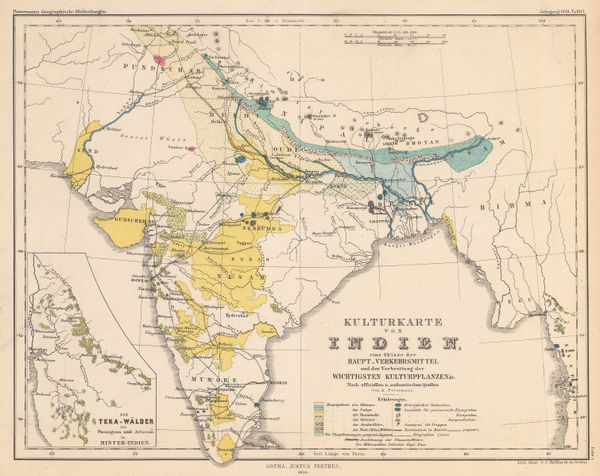
Justus Perthes, Commodity map of India, 1859£ 125.00
-
Service Hydrographique de la Marine, Rare chart of Panarea, Aeolian Islands, 1860£ 350.00
-
Archibald Fullarton, Railway Map of the British Isles, 1860 c.£ 325.00
-
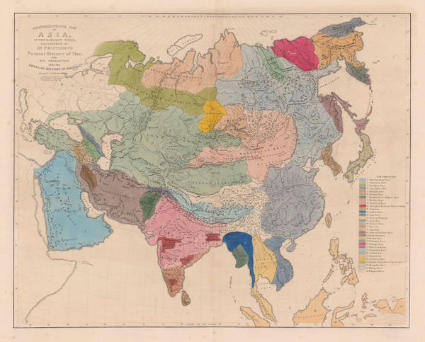
James Cowles Prichard, Ethnographic Map of Asia, 1861£ 550.00
-
James Cowles Prichard, Ethnographic Map of South America, 1861£ 450.00
-
James Cowles Prichard, Ethnographic Map of North America, 1861£ 550.00
-
J. & C. Walker, The Early Caliphates, 1862£ 275.00
-
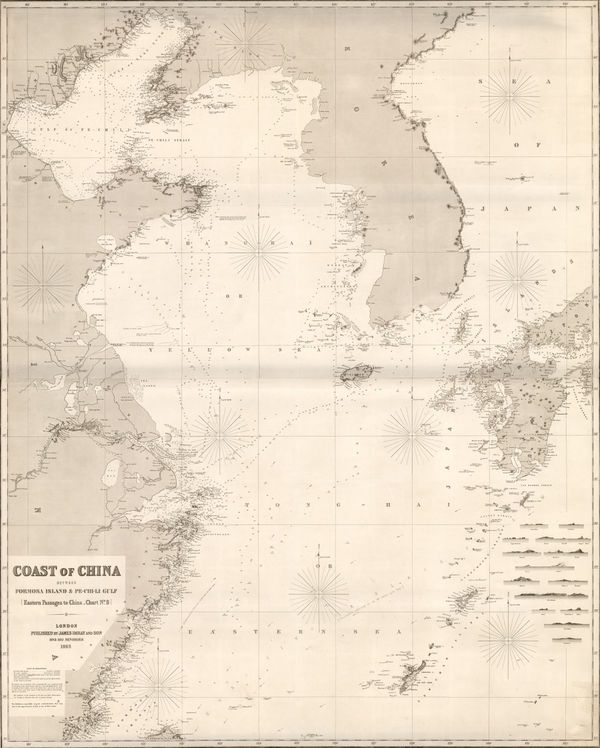
James Imray, Coast of China, Korea, and southern Japan, 1863£ 4,500.00
-
James Imray, Torres Strait and New Guinea, 1863£ 1,750.00
-
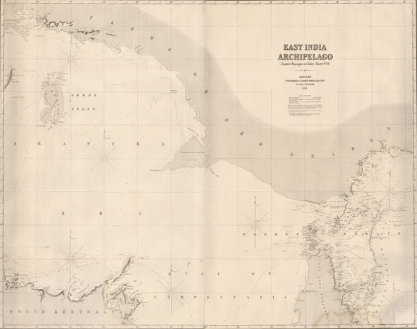
James Imray, East Indian Archipelago. (Eastern passages to China. Chart No. 5), 1863£ 885.00
-
James Imray, East Indian Archipelago. (Eastern Passages to China. Chart No.1), 1863£ 895.00
-
James Imray, East Indian Archipelago. (Eastern Passages to China. Chart No.2), 1863£ 975.00
-
James Imray, Taiwan and the North Pacific, 1863£ 2,200.00
-
James Imray, Coast of Vietnam, China, and Hong Kong, 1863£ 4,950.00
-
James Imray, East Indian Archipelago. (Western Route to China. Chart No.1), 1863£ 1,250.00
-
James Imray, Coasts of Thailand, Cambodia and Vietnam, 1863£ 1,875.00
-
Justus Perthes, Geological Map of Austria-Hungary, 1863£ 125.00
-
French Admiralty, Sea Chart of the East Coast, 1864£ 985.00
-
Edward Stanford, A New Map of Metropolitan Railways Sanctioned in 1864, 1864£ 875.00
-
Royal Geographical Society (RGS), Chart of the Currents Off the Cape of Good Hope, 1865£ 345.00
-
British Admiralty, Chart of the South East Coast of Arabia, 1865£ 3,500.00
-
British Admiralty, Fuerteventura, 1865£ 325.00
-
Justus Perthes, Geological map of Victoria, 1865£ 195.00
-
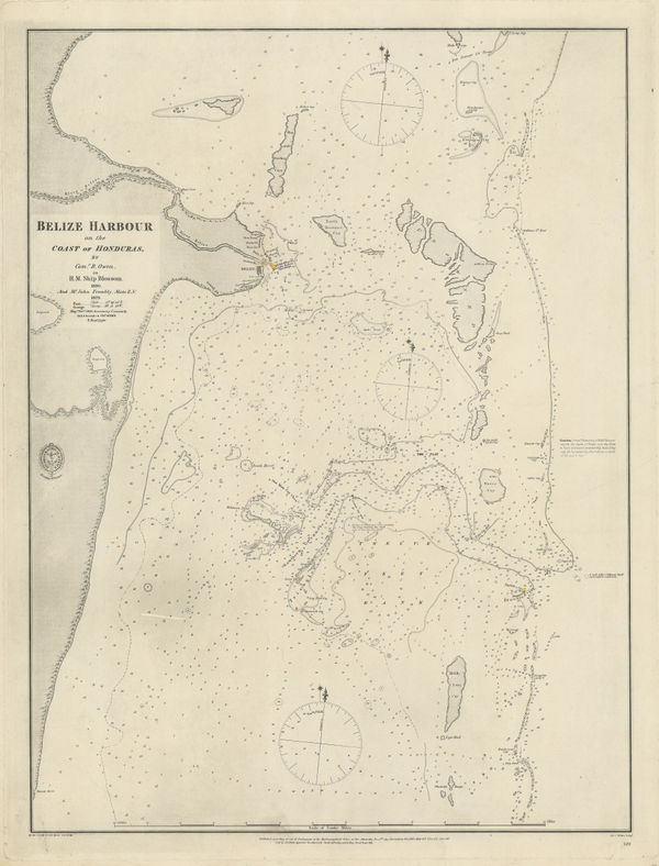
British Admiralty, Coast and Harbour of Belize City, 1866£ 785.00
-
Edward Stanford, Railway Map of the British Isles, 1866£ 385.00
-
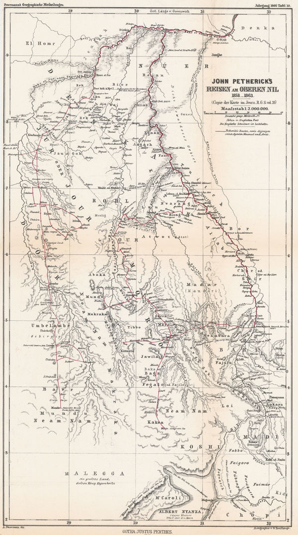
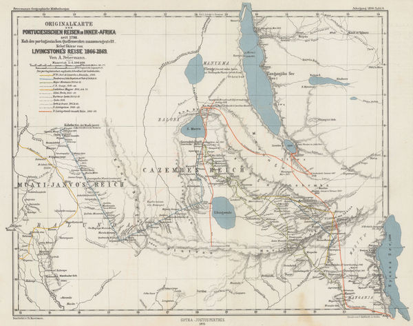
Justus Perthes, Petherick's Exploration of the White Nile, 1866£ 295.00
-
British Admiralty, Chart of the Curves of Equal Magnetic Variation 1858., 1867£ 825.00
-
British Admiralty, Kyles of Bute, 1867£ 225.00
-
Justus Perthes, Chart of the World on Mercator's Projection, 1867 c.£ 2,250.00
-
Alexander George Findlay, Chart of the North Sea, 1868£ 1,200.00
-
James Imray, Gulf of Mexico, 1868£ 3,500.00
-
French Admiralty, Chart of the Falkland Islands, 1868£ 2,450.00
-
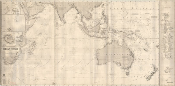
James Imray, Indian Ocean, 1868Reserved
-
Map of the Upper Part of the Island of Manhattan above eighty-sixth street arranged to illustrate the Battle of Harlem Heights, 1868Joseph ShannonJoseph Shannon, Map of the Upper Part of the Island of Manhattan above eighty-sixth street arranged to illustrate the Battle of Harlem Heights, 1868£ 395.00
-
James Imray, The Coast of the Cape Colony, 1868£ 2,250.00
-
Ordnance Survey, Geological map of Western Surrey, 1868£ 375.00
-
Justus Perthes, Arctic & Antarctic Discoveries, 1868£ 295.00
-
Bernhard Studer, Geological map of Switzerland, 1869 c.£ 1,650.00
-
Dutch edition of a rare German caricature map of Europe during the Franco-Prussian War, 1870Arnold NeumannSeries: HaarlemArnold Neumann, Dutch edition of a rare German caricature map of Europe during the Franco-Prussian War, 1870£ 3,500.00
-
Justus Perthes, Exploration of Zambia, Malawi & Tanzania, 1870£ 78.00
-
Geological Map of the Lead Region in the States of Wisconsin, Illinois and Iowa, 1870 c.J.D. WhitneyJ.D. Whitney, Geological Map of the Lead Region in the States of Wisconsin, Illinois and Iowa, 1870 c.£ 585.00
-
Spanish Admiralty, Spanish Admiralty chart of the Chesapeake Bay, 1871£ 1,450.00
-
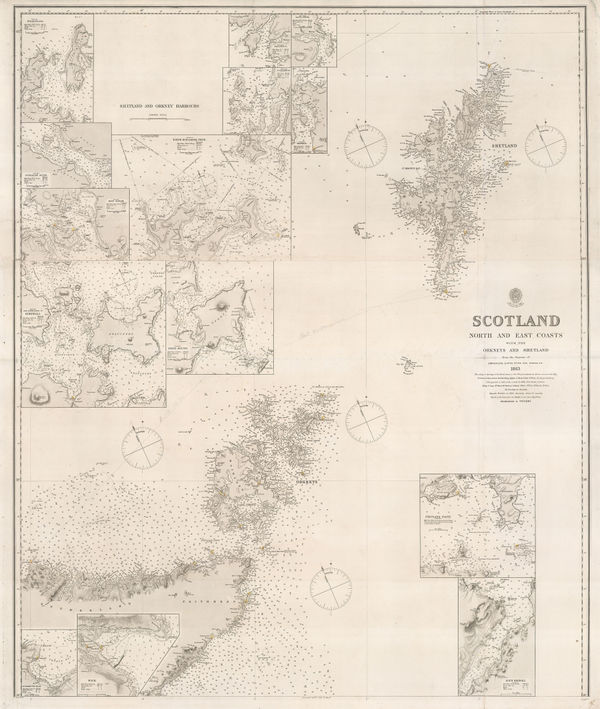
British Admiralty, Orkneys and Shetland Isles, 1872£ 325.00
-
Railway Map of the England and Wales Shewing the Districts Served by Each Railway System, 1872Edward StanfordSeries: LondonEdward Stanford, Railway Map of the England and Wales Shewing the Districts Served by Each Railway System, 1872£ 3,950.00
-
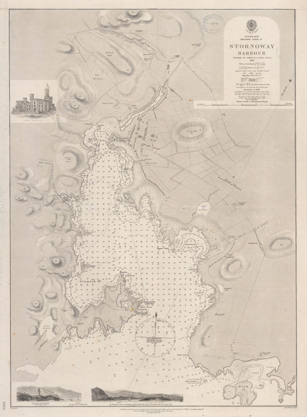
British Admiralty, Stornoway Harbour, 1874£ 150.00
-
Newton Horace Winchell, A Geological Map of The Black Hills, 1875£ 585.00
-
Jules Marcou, Geological Map of the World, 1875£ 4,250.00
-
Chart of Europe Shewing the Wrecks & Casualties to British Vessels Elsewhere than on the Coast of United Kingdom, 1875Board of Trade Wreck RegisterSeries: LondonBoard of Trade Wreck Register, Chart of Europe Shewing the Wrecks & Casualties to British Vessels Elsewhere than on the Coast of United Kingdom, 1875£ 385.00
-
Board of Trade Wreck Register, Shipwreck Chart of Britain & Ireland, 1875£ 425.00
-
Chart Shewing the Wrecks & Casualties on the Coasts of England & Wales, 1875Board of Trade Wreck RegisterSeries: LondonBoard of Trade Wreck Register, Chart Shewing the Wrecks & Casualties on the Coasts of England & Wales, 1875£ 345.00
-
Board of Trade Wreck Register, Shipwreck Chart of Britain & Ireland, 1875£ 425.00
-
Reginald A.F. Murray, Geological Map of Gipps Land, 1875£ 825.00
-
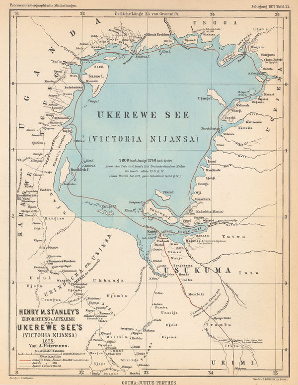
Justus Perthes, Lake Victoria according to Stanley, Speke & Grant, 1875£ 125.00
-
Justus Perthes, Coalfields of the United States, 1875£ 125.00
-
Victor Clerot, Mappemonde Orographique et Hydrographique, 1875 c.£ 4,500.00
-
Ferdinand Moritz Krause, Ararat Gold Field, 1876£ 495.00
-
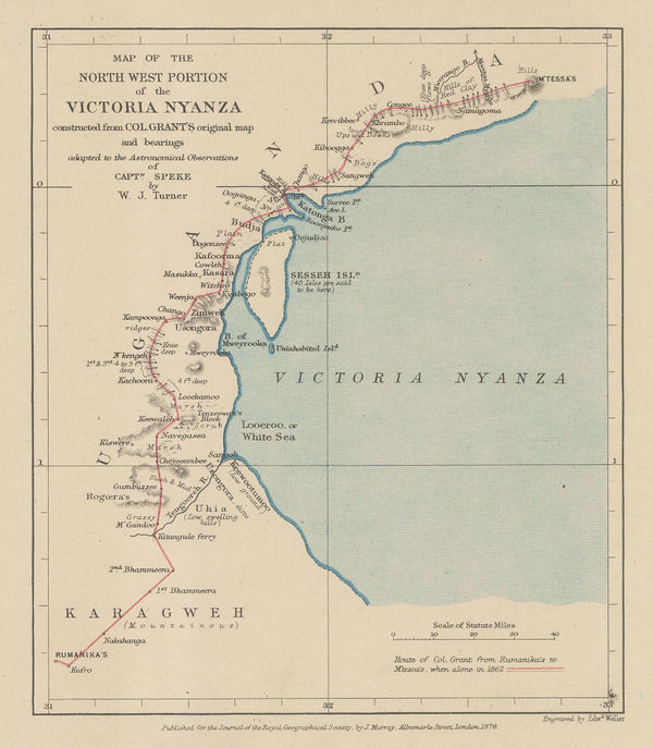
Royal Geographical Society (RGS), Lake Victoria and Uganda, 1876£ 110.00
-
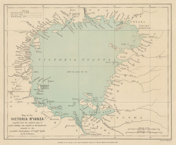
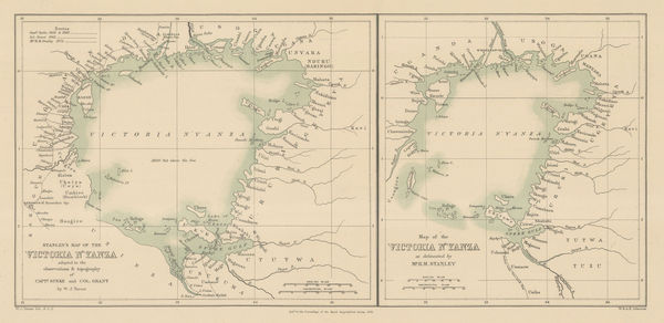
Lake Victoria according to Stanley, Speke & Grant, 1876Royal Geographical Society (RGS)Series: LondonRoyal Geographical Society (RGS), Lake Victoria according to Stanley, Speke & Grant, 1876£ 225.00
-
Lake Victoria according to Stanley, Speke & Grant, 1876Royal Geographical Society (RGS)Series: LondonRoyal Geographical Society (RGS), Lake Victoria according to Stanley, Speke & Grant, 1876£ 295.00
-
Sir Andrew Crombie Ramsay, Geological Map of England & Wales, 1876£ 725.00
-
Justus Perthes, The Russian-Turkish Border after the Crimean War, 1876£ 145.00
-
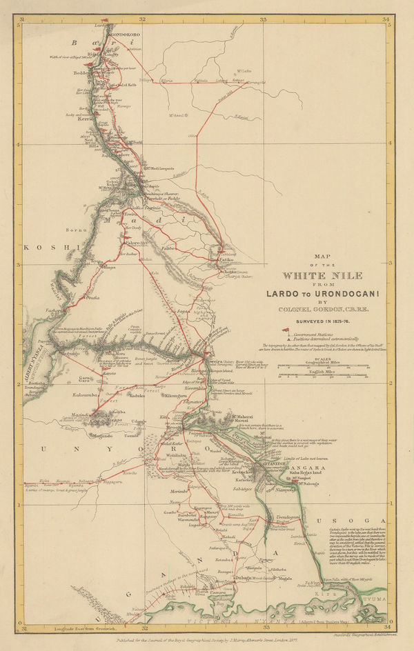
White Nile from Lake Victoria to Gondokoro (Juba), South Sudan, 1877Royal Geographical Society (RGS)Series: LondonRoyal Geographical Society (RGS), White Nile from Lake Victoria to Gondokoro (Juba), South Sudan, 1877£ 145.00
-
Survey of India, Preliminary Sketch of the Geology of India, 1877£ 1,750.00
-
Justus Perthes, Depth Chart of the Pacific Ocean, 1877£ 325.00
-
Justus Perthes, Ice Limits in the Greenland Sea, 1877£ 78.00
-
British Admiralty, Isle of Skye, 1878£ 695.00


Page
6
of 15