-
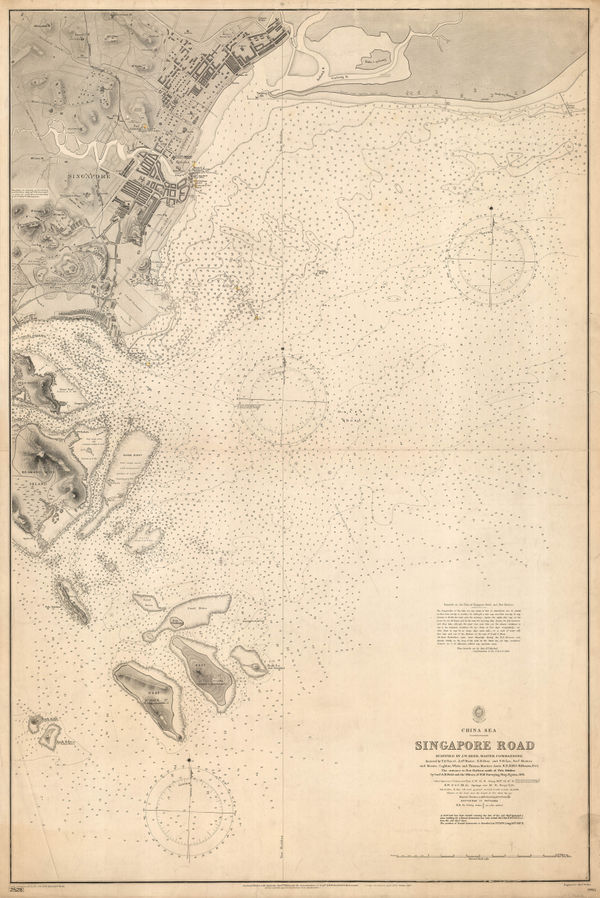
 British Admiralty, Singapore Sea Chart, 1900£ 3,750.00
 -
Charles Booth, Poverty Map of Notting Hill, Hammersmith & West Kensington, 1900£ 1,650.00
-
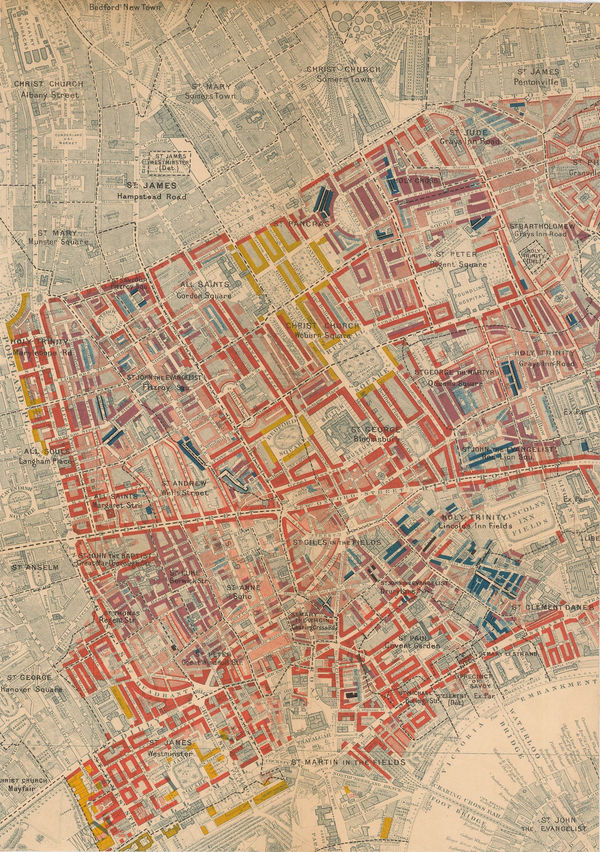
Charles Booth, West Central London, 1900£ 925.00
-
Charles Booth, Poverty Map of Lambeth, Southwark & Bermondsey, 1900£ 1,850.00
-
John Bartholomew & Co., South Polar Regions, 1900 (c.)£ 145.00
-
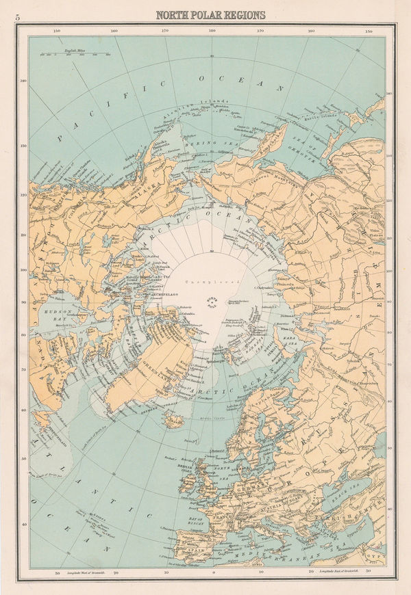
John Bartholomew & Co., North Polar Regions, 1900 (c.)£ 95.00
-
John Bartholomew & Co., Geological Map of Scotland, 1900 (c.)£ 550.00
-
George Philip, Map of the Eastern Indian Railway, 1900 c.£ 385.00
-
Charles Booth, Poverty Map of Hampstead and St. John's Wood, 1900 c.£ 1,350.00
-
Charles Booth, Poverty Map of West London, 1900 c.£ 4,950.00
-
Dr. G.A.F Molengraff, Geological Sketchmap of the Transvaal, 1902£ 825.00
-
British Admiralty, Sea Chart of Seattle & Tacoma, 1902£ 1,950.00
-
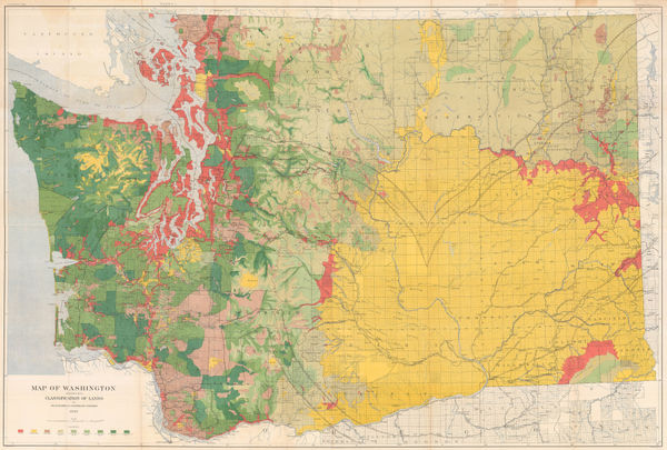
George Howard Plummer, Timber Map of Washington State, 1902£ 2,750.00
-
Survey of India, Railway System of India, 1902£ 585.00
-
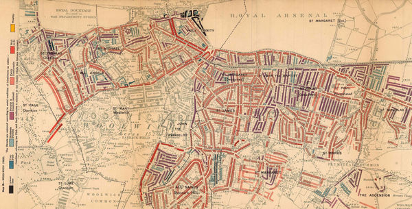
Charles Booth, Poverty Map of Woolwich & Plumstead, 1902£ 325.00
-
The "District Map" of Greater London and Environs - 1st Edition, 1902Sampson Low, Marston & CompanySeries: LondonSampson Low, Marston & Company, The "District Map" of Greater London and Environs - 1st Edition, 1902£ 400.00
-
Emil Reich, Campaigns in India, 1903£ 55.00
-
Emil Reich, India in 1804, 1903£ 65.00
-
Emil Reich, Anglo-Mysore Wars, 1903£ 58.00
-
Emil Reich, Campaigns in India 1802-1852, 1903£ 62.00
-
Emil Reich, Battle of Marston Moor and Battle of Naseby, 1903£ 55.00
-
Emil Reich, Spanish Peninsular War, 1903£ 60.00
-
Emil Reich, The British Empire about 1800, 1903£ 70.00
-
Emil Reich, English Voyages of Discovery during the Tudor Period, 1903£ 68.00
-
Emil Reich, Roman Britain, 1903£ 58.00
-
Emil Reich, Wars of the Roses, 1903£ 55.00
-
Emil Reich, The Seven Years' War in Europe and America, 1903£ 65.00
-
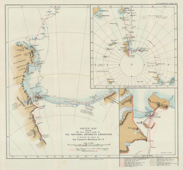
Sketch Map Showing the First Year's Work of The National Antarctic Exhibition, 1903Royal Geographical Society (RGS)Series: LondonRoyal Geographical Society (RGS), Sketch Map Showing the First Year's Work of The National Antarctic Exhibition, 1903£ 1,650.00
-
British Admiralty, Wilkes Land, Adelie Land & George V Land, 1904£ 2,500.00
-
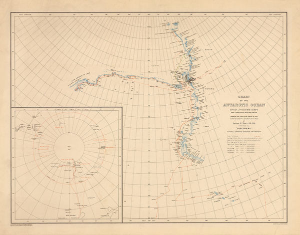
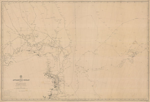
George F. A. Mulock, Chart of the Antarctic Ocean, 1904£ 1,750.00
-
Geological Survey, Geological Map of London, 1904£ 725.00
-
Ordnance Survey, Geological Survey of England and Wales, 1904£ 150.00
-
British Admiralty, Hong Kong to Gulf of Liau-Tung, 1904£ 595.00
-
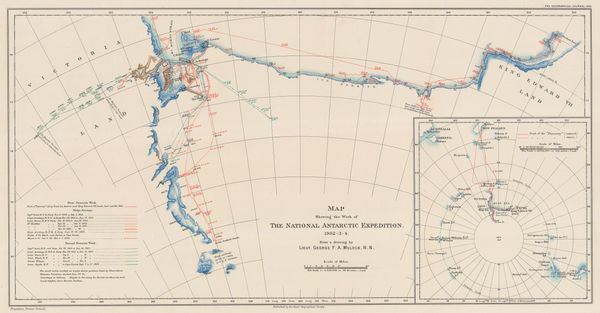
Map Showing the Work of The National Antarctic Expedition 1902-03-04, 1904Royal Geographical Society (RGS)Series: LondonRoyal Geographical Society (RGS), Map Showing the Work of The National Antarctic Expedition 1902-03-04, 1904£ 2,950.00
-
The Underground Electric Railways of London, 1904Underground Electric Railways Company of London (UERL)Series: LondonUnderground Electric Railways Company of London (UERL), The Underground Electric Railways of London, 1904£ 2,800 (framed)
-
Edward Stanford, Ancient Greece with Thessaly, 1904£ 75.00
-
George F. A. Mulock, Scott's Map of the Ross Barrier Ice Shelf, 1904£ 2,750.00
-
Anguilla to Puerto Rico shewing the Approaches to the Virgin Islands, 1905British AdmiraltySeries: LondonBritish Admiralty, Anguilla to Puerto Rico shewing the Approaches to the Virgin Islands, 1905£ 3,000.00
-
Bathymetrical Survey of the South Atlantic Ocean and Weddell Sea, 1905Scottish Geographical Society (SGS)Series: EdinburghScottish Geographical Society (SGS), Bathymetrical Survey of the South Atlantic Ocean and Weddell Sea, 1905£ 1,250.00
-
George F. A. Mulock, Robert Falcon Scott's Discovery Expedition, 1905£ 2,850.00
-
Deep Sea Deposits of the South Atlantic Ocean and Weddell Sea, 1905Scottish Geographical Society (SGS)Series: EdinburghScottish Geographical Society (SGS), Deep Sea Deposits of the South Atlantic Ocean and Weddell Sea, 1905£ 950.00
-
J.G. Bartholomew, Rubber Growing Countries, 1906£ 125.00
-
J.G. Bartholomew, States and British Representation, 1906£ 345.00
-
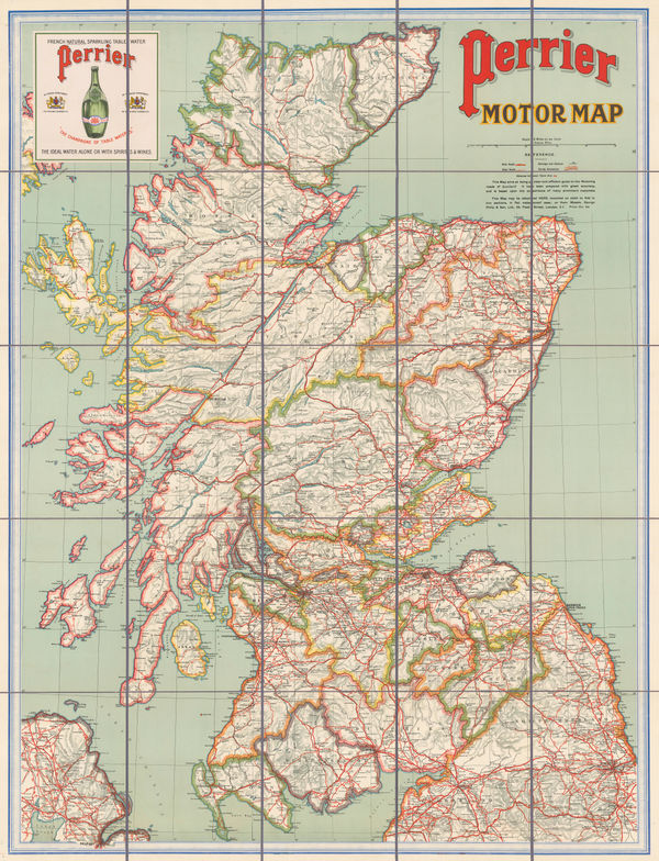
George Philip & Son Ltd., Perrier Motor Map of Scotland, 1906£ 400.00
-
Royal Geographical Society (RGS), Indian Ocean, 1906£ 195.00
-
George Philip & Son Ltd., Perrier Motor Map of England & Wales, 1906 (c.)£ 295.00
-
Ordnance Survey, Geological Survey of England and Wales, 1907£ 120.00
-
Ordnance Survey, Geological Survey of England and Wales Sheet 18 & Part of 17, 1907£ 150.00
-
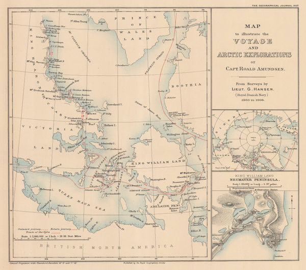
Roald Amundsen's Gjøa Expedition through the Northwest Passage, 1907Royal Geographical Society (RGS)Series: LondonRoyal Geographical Society (RGS), Roald Amundsen's Gjøa Expedition through the Northwest Passage, 1907£ 395.00
-
Railway Clearing House, Official Railway Map of London and its Environs, 1907£ 550.00
-
Ordnance Survey, Geological Map of Oxford & Environs, 1908£ 175.00
-
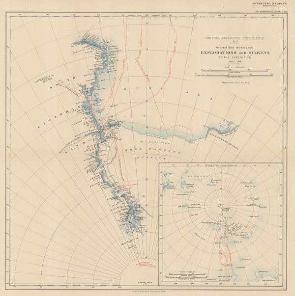
Royal Geographical Society (RGS), Shackleton's British Antarctic Expedition, 1909£ 2,200.00
-
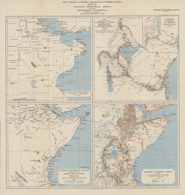
The Jubilee of Speke's Discovery of Victoria Nyanza, 1909Royal Geographical Society (RGS)Series: LondonRoyal Geographical Society (RGS), The Jubilee of Speke's Discovery of Victoria Nyanza, 1909£ 425.00
-
John Bartholomew & Co., Railways of Northeast India & Bengal, 1909£ 125.00
-
John Bartholomew & Co., Principal Economic Minerals of India, 1909£ 95.00
-
John Bartholomew & Co., Railways of South India & Sri Lanka, 1909£ 95.00
-
Chas. Baker & Co., London - A Bird's-Eye View, 1909£ 1,150.00
-
British Admiralty, Antarctic Ocean Sheet IV, 1910£ 3,500.00
-
George Philip & Son Ltd., The British Isles: Industries & Communications, 1910 c£ 245.00
-
George Philip & Son Ltd., Italy: Industries & Communications, 1910 c.£ 145.00
-
Pearson's Cycling, Motoring, and Traveller's Road Map of 50 Miles around Sydney, 1910 c.Joseph PearsonSeries: SydneyJoseph Pearson, Pearson's Cycling, Motoring, and Traveller's Road Map of 50 Miles around Sydney, 1910 c.£ 395.00
-
Romolo Bullo, Rome, 1910 c.£ 545.00
-
Joseph Pearson, Road Map of 50 Miles around Sydney, 1910 c.£ 395.00
-
George Philip & Son Ltd., Spain & Portugal: Industries & Communications, 1910 c.£ 115.00
-
Russian schematic map of the Ussuriysk, Manchurian, and Korean Railroads, 1910 c.G. De KelschSeries: St. PetersburgG. De Kelsch, Russian schematic map of the Ussuriysk, Manchurian, and Korean Railroads, 1910 c.£ 525.00
-
George Philip & Son Ltd., Australasia: Industries & Communications, 1910 c.£ 175.00
-
George W. Bacon, Bacon's Chart of Useful Knowledge, 1910 c.£ 3,600.00
-
George Philip & Son Ltd., South Africa: Industries & Communications, 1910 c.£ 185.00
-
George Philip & Son Ltd., South America: Industries & Communications, 1910 c.£ 175.00
-
George Philip & Son Ltd., Europe: Industries and Communications, 1910 c.£ 200.00
-
The East Indies & Indo-China: Industries & Communications, 1910 c.George Philip & Son Ltd.Series: LondonGeorge Philip & Son Ltd., The East Indies & Indo-China: Industries & Communications, 1910 c.£ 245.00
-
George Philip & Son Ltd., Africa: Industries & Communications, 1910 c.£ 245.00
-
George Philip & Son Ltd., Indian Empire: Industries and Communications, 1910 c.£ 225.00
-
Balkan States & Asia Minor: Industries & Communications, 1910 c.George Philip & Son Ltd.Series: LondonGeorge Philip & Son Ltd., Balkan States & Asia Minor: Industries & Communications, 1910 c.£ 125.00
-
Enciclopedia Segui, Climate Zones & Ocean Currents, 1910 c.£ 85.00
-
Karl Baedeker, Carthage, 1911£ 44.00
-
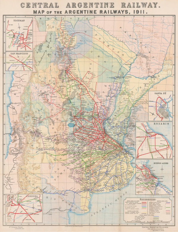
Central Argentine Railways, Map of the Argentine Railways, 1911£ 900.00
-
London Underground, The Underground Map of London, 1911£ 950.00
-
-


Page
8
of 15