-
 Edward Stanford, Geological Map of Ireland, 1912£ 55.00
 -
London Underground, London Underground Railways, 1912£ 950 (framed)
-
George Philip & Son Ltd., The Near East: Industries and Communications, 1912 c.£ 275.00
-
-
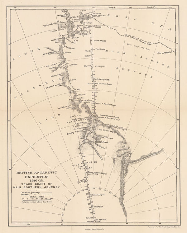
British Antarctic Expedition 1910-13. Track chart of the main southern journey, 1913Edward StanfordSeries: LondonEdward Stanford, British Antarctic Expedition 1910-13. Track chart of the main southern journey, 1913£ 450.00
-
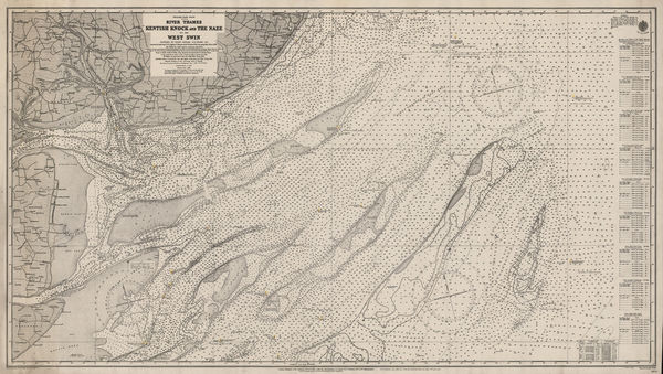
British Admiralty, River Thames, Kentish Knock and the Naze, 1913£ 175.00
-
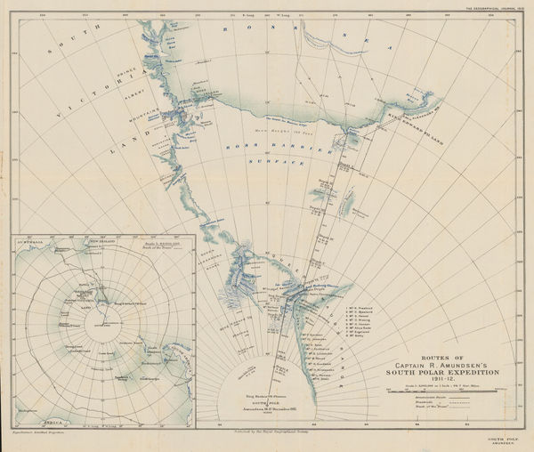
Routes of Captain R. Amundsen's South Polar Expedition 1911-1912, 1913Royal Geographical Society (RGS)Series: LondonRoyal Geographical Society (RGS), Routes of Captain R. Amundsen's South Polar Expedition 1911-1912, 1913£ 4,950.00
-
Edward Stanford, Railway Map of the US & Canada, 1913£ 1,450.00
-
British Admiralty, Heroic Age map of the Ross Sea & Ross Ice Shelf, 1914£ 4,500.00
-
Edward Fisher Pittman, Geological Map of New South Wales, 1914£ 1,450.00
-
British Admiralty, Karachi Harbour, 1914£ 2,500.00
-
British Admiralty, Fiji - Nukulau Island to Namuka Island, 1914£ 475.00
-
-
-
Editions-G.D., WWI French caricature map of Europe, 1915£ 4,500.00
-
James Perrin Smith, Geological Map of California, 1916£ 4,000.00
-
Royal Geographical Society (RGS), Railway map of Africa, 1916£ 485.00
-
The Graphic Magazine, WWI - the Battle of Verdun, 1916£ 125.00
-
London Underground, Underground Map of London with some Motor Bus Extensions, 1916£ 625 (framed)
-
Royal Geographical Society (RGS), Geological Map of New Caledonia, 1917£ 285.00
-
Edward Stanford, Trans-Siberian Railway, 1917£ 1,250.00
-
British Admiralty, Turks Islands, 1917£ 945.00
-
G. Delattre & Cie., First World War French propaganda poster, 1917 c.£ 825.00
-
Railway Clearing House, Official Railway Map of the West of England, 1918£ 395.00
-
Ordnance Survey, Heligoland 28th August 1914 General Chart of the Action, 1919£ 225.00
-
Louis Gentil, Geological map of Morocco, 1920£ 945.00
-
Ordnance Survey, Geological Survey of England and Wales, 1920£ 150.00
-
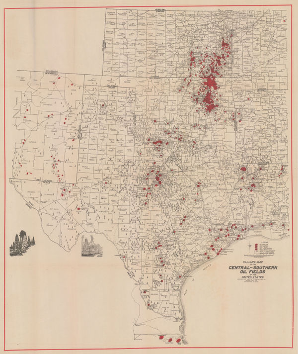
F.E. Gallup, Map of the Central-Southern Oil Fields, 1920£ 3,450.00
-
Africa showing British possessions at their height, 1920Royal Geographical Society (RGS)Series: LondonRoyal Geographical Society (RGS), Africa showing British possessions at their height, 1920£ 345.00
-
Relief Map of the Territory Served by the Lines of the Pacific Electric Railway in Southern California, 1920O.A. SmithO.A. Smith, Relief Map of the Territory Served by the Lines of the Pacific Electric Railway in Southern California, 1920£ 950.00
-
George Philip & Son Ltd., Strategic Record Map of the Western Front, 1920 c£ 345.00
-
Harmsworth, Dixmude to Arras, 1920 c.£ 44.00
-
Harmsworth, Lens and Arras, 1920 c.£ 42.00
-
Clason Map Co., Prospector's Guide of Colorado, 1920 c.£ 425.00
-
Harmsworth, Western Front (British and German Attacks), 1920 c.£ 75.00
-
Harmsworth, Western Front - Cambrai and Bourlon Wood, 1920 c.£ 58.00
-
Harmsworth, Western Front : Loos and Hohenzollern Redoubt, 1920 c.£ 68.00
-
Harmsworth, Battle of the Somme, 1920 c.£ 86.00
-
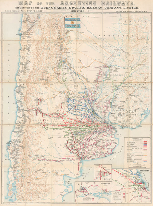
Waterlow & Sons, Railway Map of Argentina, 1921£ 1,350.00
-
Macdonald Gill, Map of Electric Railways of London, 1921£ 1,350.00
-
British Admiralty, Chart of the Island of Ceylon with the Adjacent Coast of India, 1922£ 3,450.00
-
Kinosuke Inouye, Map of Applied Geology - Japan - Copper, 1922£ 495.00
-
Kue Shan Is. to the Yang Tse Kiang including the Chusan Archipelago, 1922British AdmiraltySeries: LondonBritish Admiralty, Kue Shan Is. to the Yang Tse Kiang including the Chusan Archipelago, 1922£ 1,450.00
-
British Admiralty, Aegean Sea and Islands, 1922£ 1,450.00
-
Royal Geographical Society (RGS), The Geology of the Mount Everest Region, 1922£ 675.00
-
John Bartholomew & Son, World Map of Vegetation and Ocean Currents, 1922£ 175.00
-
John Bartholomew & Son, World Maps throughout History, 1922£ 145.00
-
British Admiralty, Amoy to Nagasaki, 1923£ 1,350.00
-
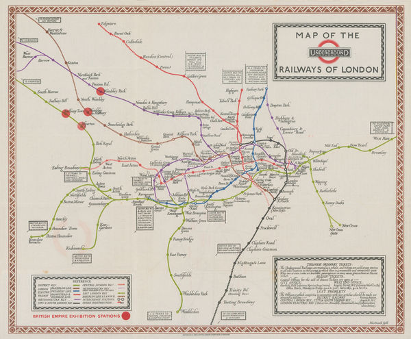
Kennedy North, British Empire Exhibition 1924, 1923£ 650.00
-
British Admiralty, Rare chart of Taiwan (Formosa) and the Taiwan Strait, 1923£ 3,950.00
-
British Admiralty, Rare and detailed chart of northern Taiwan (Formosa), 1923£ 2,950.00
-
British Admiralty, Gogo Shima to Miyo Shima including Kurushima Kaikyo, 1923£ 495.00
-
-
-
-
British Admiralty, Japan. Naikai or Inland Sea. Izumi Nada and Harima Nada, 1923£ 495.00
-
British Admiralty, Japan. Shimonoseki Kaikyo, 1923£ 495.00
-
British Admiralty, Kiaochow Bay, 1923£ 985.00
-
-
British Admiralty, Malacca Straits, 1923£ 1,150.00
-
British Admiralty, Ozuchi Jima to Funoka Sima, 1923£ 495.00
-
James Reynolds, Reynolds's New Chart of the Thames Estuary, 1923£ 265.00
-
British Admiralty, The Brothers to Ockseu Is., 1923£ 1,950.00
-
Macdonald Gill, Map of the Underground Railways of London, 1923£ 1,650 (framed)
-
British Admiralty, Singapore Sea Chart, 1924£ 3,250.00
-
James Imray, Mouth of the River Thames, 1924£ 525.00
-
Waterlow & Sons, Underground Map of London, 1924£ 750.00
-
Macdonald Gill, The Wonderground Map of London, 1924 c.£ 4,800 (framed)
-
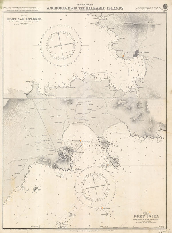
British Admiralty, Anchorages in the Balearic Islands, 1925£ 925.00
-
Ordnance Survey, Geological Survey of England and Wales, 1925£ 120.00
-
J.C. Betts, Underground Railways of London, 1925£ 825.00
-
A. Trüb & Cie, Spain and Portugal, 1925 c.£ 750.00
-
Y Koshiba, Geological Map of Japanese Empire, 1926£ 1,550.00
-
Plan of Anuradhapura and Environs shewing Ancient Ruins, 1926Ceylon Survey DepartmentSeries: AnuradhapuraCeylon Survey Department, Plan of Anuradhapura and Environs shewing Ancient Ruins, 1926£ 645.00
-
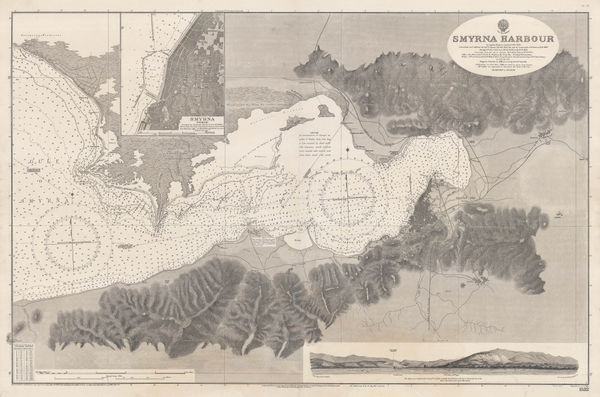
British Admiralty, Smyrna Harbour, 1926£ 985.00
-
British Admiralty, Anamba Islands, 1927£ 325.00
-
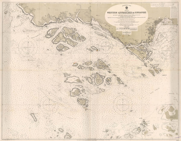
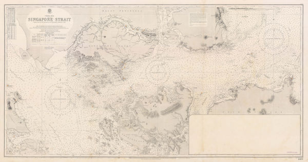
British Admiralty, Singapore Strait Sea Chart, 1927£ 3,950.00
-
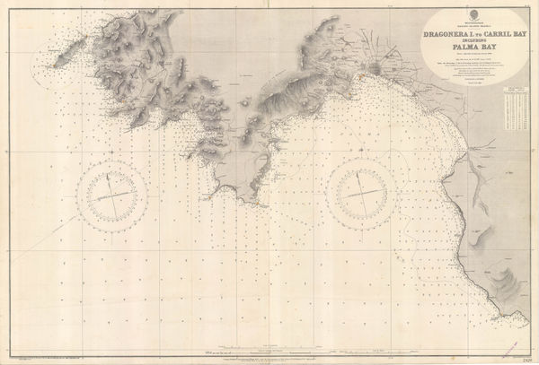
British Admiralty, Dragonera Island to Carril Bay, 1927£ 575.00
-
British Admiralty, Guernsey, Herm and Sark, 1927£ 675.00
-
British Admiralty, Island of Jersey, 1927£ 675.00


Page
9
of 15