-
 Sebastian Münster, Pakistan & Afghanistan, 1552£ 575.00
 -
Petrus Bertius, Early miniature map of the Malabar Coast, 1616£ 325.00
-
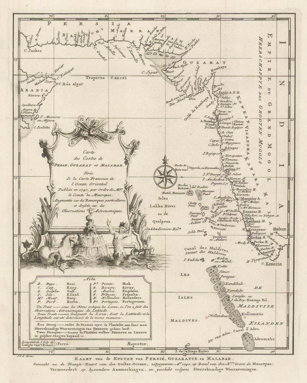
Vincenzo Coronelli, Impero Del Gran Mogol, 1692 c.£ 1,450.00
-
Samuel Thornton, Chart of Mumbai (Bombay) to Diu Head, 1711£ 1,100.00
-
Samuel Thornton, A New Chart of the Coast of Orixa and Galconda, 1711£ 450.00
-
Emanuel Bowen, The Deccan and Southern India, 1744£ 425.00
-
Jacob van der Schley, Western coast of the Indian Peninsula and the Maldives, 1747£ 185.00
-
Jacques-Nicolas Bellin, Southern India & Sri Lanka, 1750 c.£ 225.00
-
Jacques-Nicolas Bellin, Northwest India, 1752£ 365.00
-
London Magazine, The Coast of Andhra Pradesh, 1757£ 125.00
-
Jacques-Nicolas Bellin, Southeastern India during the Seven Years War, 1757£ 125.00
-
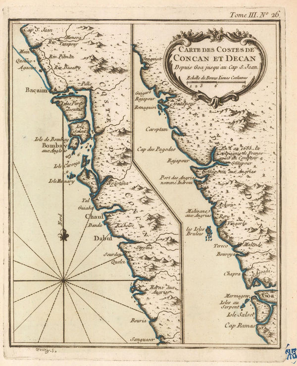
Jacques-Nicolas Bellin, Chart of the coast of Concan and Decan, 1764£ 115.00
-
Jacques-Nicolas Bellin, Chart of the Gulf of Khambhat (Cambay), 1764£ 115.00
-
Jacques-Nicolas Bellin, Coasts of Malabar and Kanara, 1764£ 345.00
-
Jacques-Nicolas Bellin, The Mouth of the Hooghly River, 1764£ 175.00
-
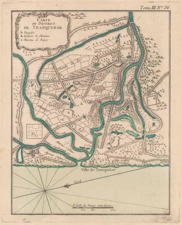
Jacques-Nicolas Bellin, Tharangambadi (Tranquebar), 1764£ 245.00
-
Jacques-Nicolas Bellin, Goa, 1764£ 225.00
-
Jacques-Nicolas Bellin, West Bengal & Bangladesh, 1764£ 325.00
-
Jacques-Nicolas Bellin, The Coast of Andhra Pradesh (Coromandel), 1764£ 175.00
-
Thomas Kitchin, A Map of the Coast of Coromandel, 1765 c.£ 425.00
-
Robert Orme, Coromandel from the Coleroon to Cape Comorin, 1778£ 645.00
-
Robert Orme, The Carnatic from the Pennar to the Coleroon, 1778£ 495.00
-
James Rennell, Jungleterry District, 1779£ 295.00
-
John Bew, Southern India, 1781£ 245.00
-
Robert Orme, Central India, 1782£ 225.00
-
Robert Orme, Southern India - Tamil Nadu & Kerala, 1782£ 225.00
-
Joseph Tiefenthaler, The River Ganges, 1784£ 4,500.00
-
James Rennell, Ganges Delta, 1785£ 1,450.00
-
Laurie & Whittle, A Chart of the Coast of India, from Goa to Cape Comorin, 1794£ 1,250.00
-
Laurie & Whittle, Uttar Pradesh, 1794£ 450.00
-
The Coast of India between Calymere and Gordeware Points including the Coast of Coromandel, 1794Laurie & WhittleSeries: LondonLaurie & Whittle, The Coast of India between Calymere and Gordeware Points including the Coast of Coromandel, 1794£ 1,250.00
-
Laurie & Whittle, The Coast of India from Point Gordeware to the Ganges, 1794£ 985.00
-
Laurie & Whittle, The Coast of India from Point Jigat to Cape Ramas, 1794£ 1,250.00
-
Pierre Tardieu, Southern India and Sri Lanka (Ceylon), 1798£ 175.00
-
William Faden, A Map of the Peninsula of India, 1800£ 1,550.00
-
-
Charles Smith, Peninsula of India, 1808£ 115.00
-
Robert Wilkinson, The Southern Provinces of Hindoostan, 1808£ 115.00
-
John Thomson, Southern India, 1816£ 195.00
-
John Thomson, Northern India, Nepal & Afghanistan, 1817£ 495.00
-
A Geological Sketch of Malwa, and part of the Adjoining Provinces, 1823Capt. F. DangerfieldSeries: LondonCapt. F. Dangerfield, A Geological Sketch of Malwa, and part of the Adjoining Provinces, 1823£ 95.00
-
Map of Central India, including Malwa, and the adjoining provinces, 1823Aaron ArrowsmithSeries: LondonAaron Arrowsmith, Map of Central India, including Malwa, and the adjoining provinces, 1823£ 445.00
-
Society for the Diffusion of Useful Knowledge (SDUK), Eastern India, 1832£ 35.00
-
Society for the Diffusion of Useful Knowledge (SDUK), Northwest India, 1833£ 75.00
-
Royal Geographical Society (RGS), Sketch of Part of the Himma-Leh Mountains, 1834£ 120.00
-
Northeastern India - Bahar and Orissa, 1840 c.Society for the Diffusion of Useful Knowledge (SDUK)Series: LondonSociety for the Diffusion of Useful Knowledge (SDUK), Northeastern India - Bahar and Orissa, 1840 c.£ 45.00
-
James Wyld, Map of the Peninsula of India, 1840 c.£ 695.00
-
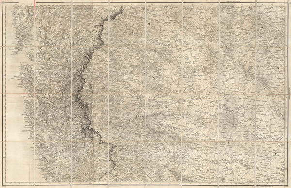
John Walker, Map of the Countries on the North West Frontier of India, 1841£ 4,850.00
-
Map of Afghaunistan, Caubul, The Punjab, Rajpootana and the River Indus, 1842James WyldSeries: LondonJames Wyld, Map of Afghaunistan, Caubul, The Punjab, Rajpootana and the River Indus, 1842£ 1,950.00
-
John Tallis, Southern India, 1851£ 385.00
-
John Tallis, Northern India, 1851£ 385.00
-
Royal Geographical Society (RGS), Part of the Himalaya Mountains, 1851£ 185.00
-
J. & C. Walker, Map of the Punjab, Western Himalaya, and adjoining parts of Tibet, 1854£ 2,450.00
-
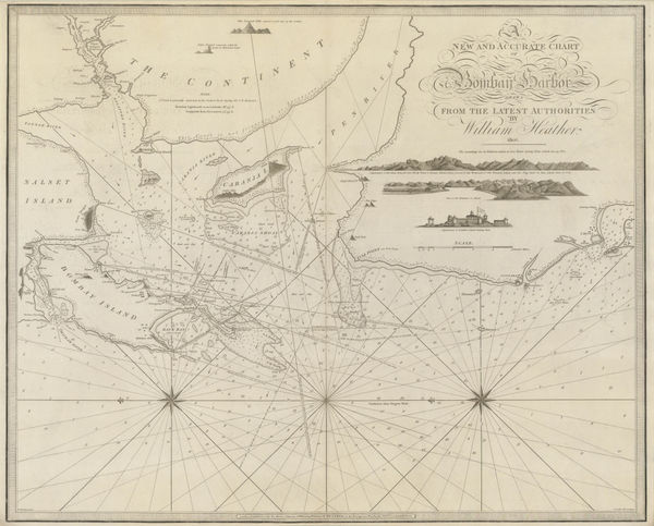
John Walker, Mumbai & Western Maharashtra, 1855£ 595.00
-
Survey of India, Map of Kashmir with Part of Adjacent Mountains, 1859£ 2,450.00
-
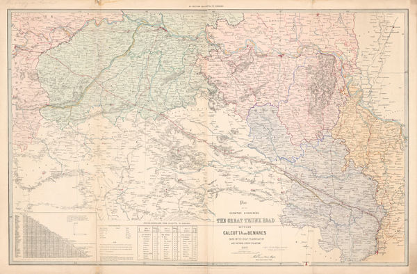
Survey of India, Grand Trunk Road of India between Calcutta and Benares, 1860 c£ 2,000.00
-
Survey of India, Great Trunk Road of India between Benares and Delhi, 1860 c£ 4,000.00
-
Justus Perthes, Sikkim and the Nepalese frontier, 1861£ 66.00
-
Royal Geographical Society (RGS), Map of the Valley of Kashmir, 1861£ 245.00
-
Northeast Indian states of Tripura, Meghalaya and Manipur and Sri Lanka, 1863Edward WellerSeries: LondonEdward Weller, Northeast Indian states of Tripura, Meghalaya and Manipur and Sri Lanka, 1863£ 65.00
-
Justus Perthes, North-central India, 1864£ 55.00
-
Justus Perthes, Bustar and the Central Provinces, 1864£ 95.00
-
Royal Geographical Society (RGS), Sketch Map of the Basin of the Mahanuddy, 1865£ 120.00
-
Map of the Coast of Travancore Coast and Black Waters, showing the anchorage at Alipee, 1866Royal Geographical Society (RGS)Series: LondonRoyal Geographical Society (RGS), Map of the Coast of Travancore Coast and Black Waters, showing the anchorage at Alipee, 1866£ 98.00
-
Royal Geographical Society (RGS), The Wurkallay Barrier, 1866£ 98.00
-
Sketch map of North Eastern India with portions of Burmah & China, 1867Royal Geographical Society (RGS)Series: LondonRoyal Geographical Society (RGS), Sketch map of North Eastern India with portions of Burmah & China, 1867£ 86.00
-
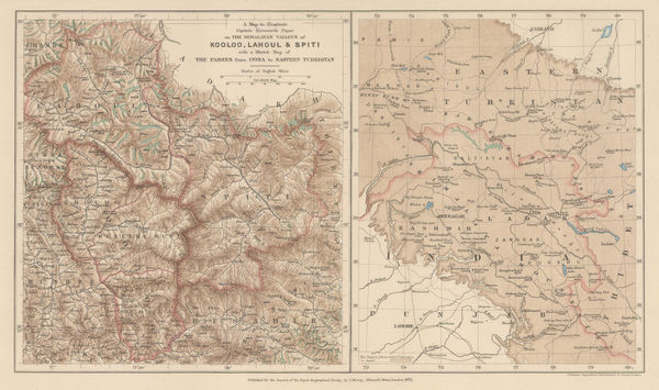
A Map to Illustrate Captain Harcourts Paper on the Himalayan Valleys of Kooloo, Lahoul & Spiti, 1871Royal Geographical Society (RGS)Series: LondonRoyal Geographical Society (RGS), A Map to Illustrate Captain Harcourts Paper on the Himalayan Valleys of Kooloo, Lahoul & Spiti, 1871£ 325.00
-
Justus Perthes, G.W. Hayward’s journey from Leh to Kashgar, 1871£ 98.00
-
Edward Weller, Map of Sikkim, 1876 c.£ 345.00
-
Justus Perthes, Pamir and Kashgar, 1877£ 425.00
-
Southeastern Pakistan, Gujarat and Rajastan, 1879Society for the Diffusion of Useful Knowledge (SDUK)Series: LondonSociety for the Diffusion of Useful Knowledge (SDUK), Southeastern Pakistan, Gujarat and Rajastan, 1879£ 125.00
-
Maharashtra and Karnataka provinces, 1879Society for the Diffusion of Useful Knowledge (SDUK)Series: LondonSociety for the Diffusion of Useful Knowledge (SDUK), Maharashtra and Karnataka provinces, 1879£ 125.00
-
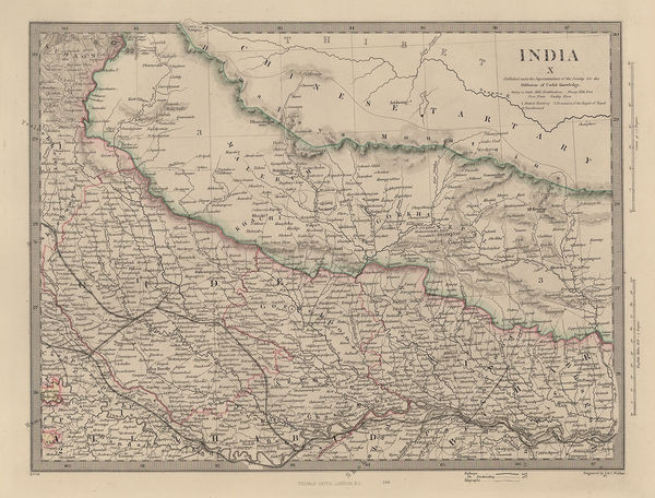
Nepal, Bihar & Uttar Pradesh, 1879Society for the Diffusion of Useful Knowledge (SDUK)Series: LondonSociety for the Diffusion of Useful Knowledge (SDUK), Nepal, Bihar & Uttar Pradesh, 1879£ 155.00
-
Map of Sikkim and parts of the Adjacent Territories, 1881Royal Geographical Society (RGS)Series: LondonRoyal Geographical Society (RGS), Map of Sikkim and parts of the Adjacent Territories, 1881£ 125.00
-
Letts & Son, Eastern India and Nepal, 1882£ 85.00
-
Letts & Son, Southern India, 1882£ 85.00
-
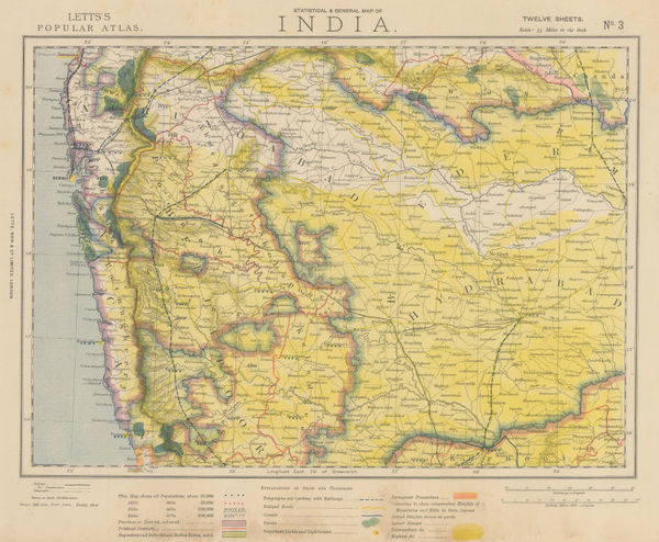
Letts & Son, Southwestern India, 1882£ 85.00
-
Letts & Son, Bay of Bengal coast, 1882£ 85.00
-
Letts & Son, Central India - Chota Nagpur Division, 1882£ 85.00
-
Letts & Son, Northwest India - Lahore, Kashmir & Himachal Pradesh, 1883£ 78.00


Page
1
of 2