-
 Johnson & Browning, Johnson's Kentucky and Tennessee, 1861£ 160.00
 -
Johnson & Browning, Johnson's Ohio and Indiana, 1861£ 195.00
-
Map Illustrating the plan of the defences of the Western & North Western Frontier, 1861Washington HoodSeries: PhiladelphiaWashington Hood, Map Illustrating the plan of the defences of the Western & North Western Frontier, 1861£ 525.00
-
General Land Office (GLO), Sketch of Public Surveys in New Mexico, 1861£ 895.00
-
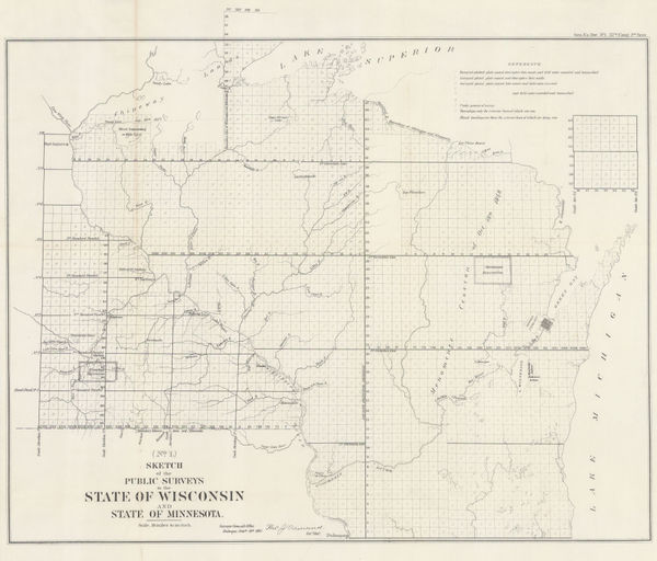
Sketch of the Public Surveys in the State of Wisconsin and State of Minnesota, 1861US GovernmentSeries: Washington, D.C.US Government, Sketch of the Public Surveys in the State of Wisconsin and State of Minnesota, 1861£ 325.00
-
US Government, Sketch of the Public Surveys of Iowa and Dakota, 1861£ 295.00
-
Edward Stanford, Civil War Map of the Eastern United States, 1861£ 2,850.00
-
W. & A.K. Johnston, Civil War Map of the United States, 1861£ 595.00
-
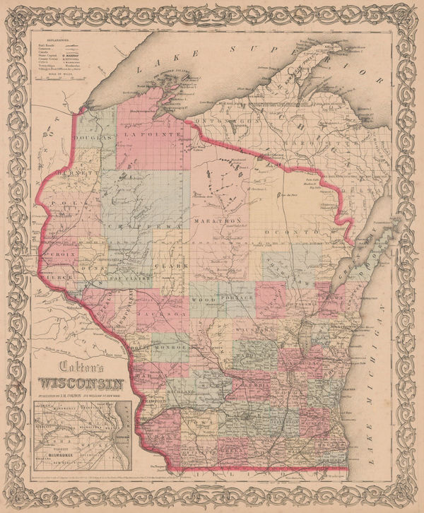
Joseph Hutchins Colton, Wisconsin, 1861£ 325.00
-
Joseph Hutchins Colton, Illinois, 1861£ 195.00
-
Joseph Hutchins Colton, Philadelphia, 1861£ 275.00
-
Joseph Hutchins Colton, Florida, 1861£ 495.00
-
Joseph Hutchins Colton, South Carolina, 1861£ 345.00
-
Joseph Hutchins Colton, Savannah and Charleston, 1861£ 375.00
-
Joseph Hutchins Colton, Connecticut, 1861£ 295.00
-
Joseph Hutchins Colton, North Carolina, 1861£ 325.00
-
Joseph Hutchins Colton, Michigan, 1861£ 295.00
-
Joseph Hutchins Colton, Indiana, 1861£ 225.00
-
Joseph Hutchins Colton, Louisville and New Orleans, 1861£ 295.00
-
Roswell C. Smith, Civil War-Era Map of the Western US, 1861£ 745.00
-
Joseph Hutchins Colton, Canada, Alaska & Greenland, 1861£ 195.00
-
Joseph Hutchins Colton, Hawaii, New Zealand & Pacific Islands, 1861£ 295.00
-
James Cowles Prichard, Ethnographic Map of North America, 1861£ 550.00
-
Joseph Hutchins Colton, Georgia, 1862£ 325.00
-
Joseph Hutchins Colton, Minnesota and Dakota, 1862£ 345.00
-
Joseph Hutchins Colton, Massachusettes and Rhode Island , 1862£ 325.00
-
Joseph Hutchins Colton, Ohio, 1862£ 195.00
-
Joseph Hutchins Colton, Louisiana, 1862£ 245.00
-
Joseph Hutchins Colton, Virginia, 1862£ 375.00
-
Samuel Augustus Mitchell, County Map of Minnesota, 1862£ 245.00
-
F.A. Garnier, Civil War map of the United States, 1862 c£ 595.00
-
Johnson & Ward, Johnson's Georgia and Alabama, 1863£ 275.00
-
Johnson & Ward, Johnson's Iowa and Nebraska, 1863£ 150.00
-
Harper's Magazine, Confederate United States, 1863£ 575.00
-
Edward Weller, United States [West Sheet], 1863£ 225.00
-
Matthew Dripps, New York City , 1863£ 2,750.00
-
Alvin J. Johnson, Johnson's Florida, 1863£ 325.00
-
French Admiralty, Sea Chart of the East Coast, 1864£ 985.00
-
Phelps & Watson, Historical and Military Map of the Border and Southern States, 1864£ 1,550.00
-
Johnson & Ward, Illinois, 1864£ 245.00
-
Johnson & Ward, Indiana, 1864£ 195.00
-
Johnson & Ward, Johnson's Iowa and Nebraska, 1864£ 295.00
-
Johnson & Ward, Johnson's Ohio, 1864£ 295.00
-
Johnson & Ward, Johnson's Pennsylvania and New Jersey, 1864£ 195.00
-
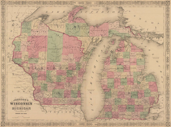
Johnson & Ward, Johnson's Wisconsin and Michigan, 1864£ 325.00
-
Magnus' Historical War Map - One Hundred & Fifty Miles Around Richmond, 1864Charles MagnusSeries: New YorkCharles Magnus, Magnus' Historical War Map - One Hundred & Fifty Miles Around Richmond, 1864£ 1,250.00
-
Map of Explorations and Surveys in New Mexico and Utah, 1864Capt. John Navarre MacombSeries: New YorkCapt. John Navarre Macomb, Map of Explorations and Surveys in New Mexico and Utah, 1864£ 2,750.00
-
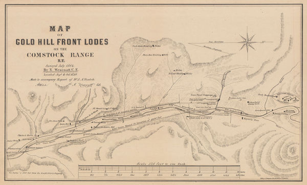
Nelson Wescoatt, Map of Gold Hill Front Lodes on the Comstock Range, 1864£ 895.00
-
James T. Lloyd, Railroad, Telegraph and Express Map of the United States, 1864£ 2,750.00
-
Vermont, New Hampshire, Massachusetts, Rhode Island, and Connecticut, 1864Johnson & WardSeries: New YorkJohnson & Ward, Vermont, New Hampshire, Massachusetts, Rhode Island, and Connecticut, 1864£ 185.00
-
Johnson & Ward, Johnson's Kentucky and Tennessee, 1865£ 285.00
-
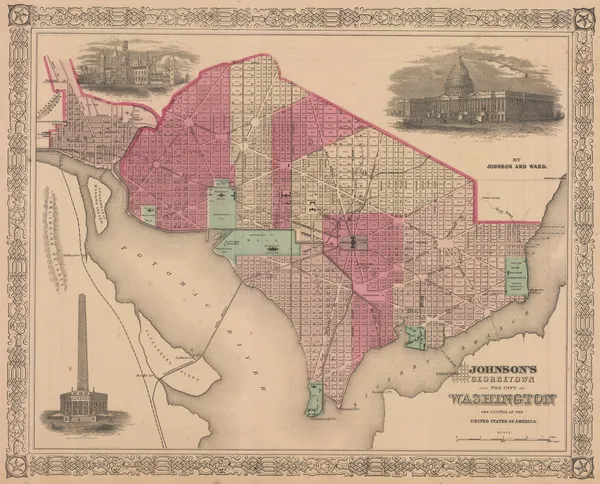
Johnson & Ward, Georgetown and the City of Washington, 1865£ 385.00
-
Matthew Dripps, New York City & Vicinity, 1865£ 2,450.00
-
William Veazie, New England, 1865£ 725.00
-
Johnson & Ward, Johnson's Arkansas, Mississippi and Louisiana, 1866£ 295.00
-
Johnson & Ward, Johnson's Maine, 1866£ 185.00
-
Johnson & Ward, Johnson's New York, 1866£ 195.00
-
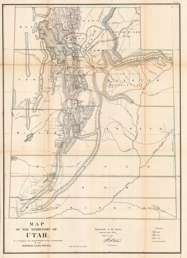
General Land Office (GLO), Map of the Territory of Utah, 1866£ 795.00
-
-
General Land Office (GLO), Map of the United States and Territories, 1866£ 4,000.00
-
General Land Office (GLO), Map showing the progress of the Surveys in Kansas and Nebraska, 1866£ 595.00
-
General Land Office (GLO), Indiana, 1866£ 295.00
-
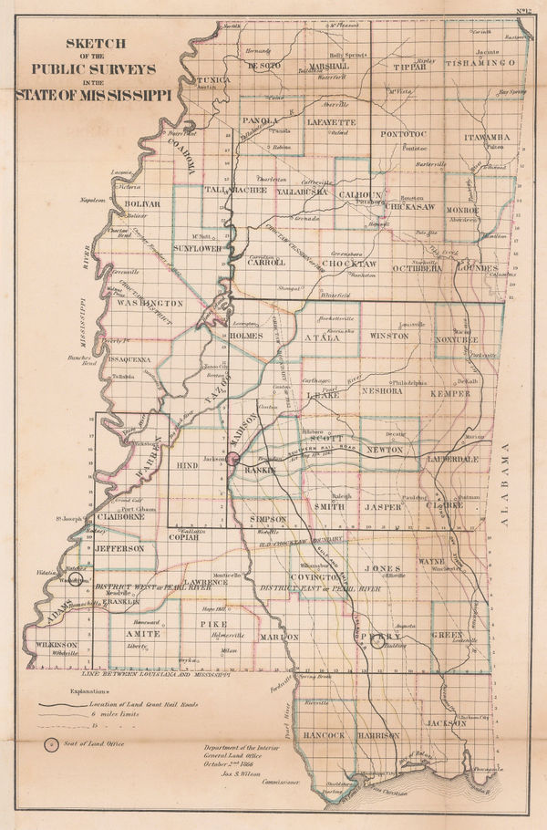
General Land Office (GLO), Mississippi, 1866£ 295.00
-
General Land Office (GLO), Alabama, 1866£ 375.00
-
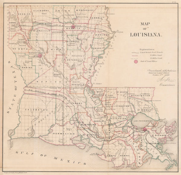
General Land Office (GLO), Louisiana, 1866£ 475.00
-
General Land Office (GLO), Arkansas, 1866£ 345.00
-
General Land Office (GLO), Iowa, 1866£ 345.00
-
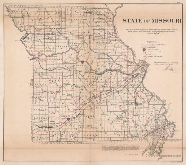
General Land Office (GLO), Missouri, 1866£ 295.00
-
General Land Office (GLO), Illinois, 1866£ 650.00
-
General Land Office (GLO), Oregon, 1866£ 1,450.00
-
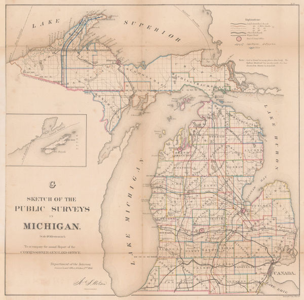
General Land Office (GLO), Michigan, 1866£ 850.00
-
General Land Office (GLO), Minnesota, 1866£ 850.00
-
General Land Office (GLO), Florida, 1866£ 1,350.00
-
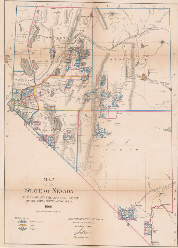
General Land Office (GLO), Nevada, 1866£ 1,500.00
-
General Land Office (GLO), Dakota Territory, 1866£ 795.00
-
Alvin J. Johnson, Johnson's Texas, 1866£ 445.00
-
General Land Office (GLO), Ohio, 1866£ 375.00
-
General Land Office (GLO), Sketch of Public Surveys in New Mexico and Arizona, 1866£ 1,750.00
-
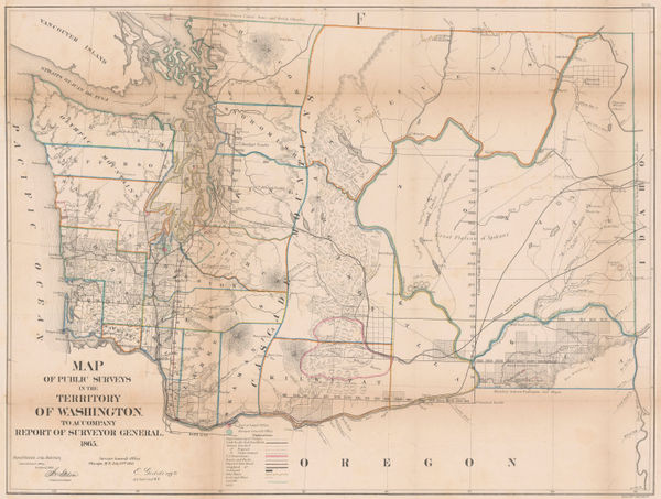
General Land Office (GLO), Map of the Public Surveys of the Territory of Washington, 1866£ 1,450.00
-
Samuel Augustus Mitchell, County Map of the States of Iowa and Missouri, 1867£ 90.00


![Edward Weller, United States [West Sheet], 1863](https://static-assets.artlogic.net/w_600,c_limit,f_auto,fl_lossy,q_auto/artlogicstorage/themaphouse/images/view/3cefd76756f06e726498aa52f2f443cbj/themaphouse-edward-weller-united-states-west-sheet-1863.jpg)


Page
8
of 16