All Maps
- All
- AFRICA
- ▪ Central Africa
- ▪ East Africa
- ▪ North Africa
- ▪ Southern Africa
- ▪ West Africa
- ▪ Atlantic Islands
- AMERICAS
-
▪ United States (USA)
- USA - East
- USA - Midwest
- USA - Northeast
- USA - Southeast
- USA - West & Southwest
- Alabama
- Alaska
- Arizona
- Arkansas
- California
- Colorado
- Connecticut
- Delaware
- Florida
- Georgia
- Hawaii
- Idaho
- Illinois
- Indiana
- Iowa
- Kansas
- Kentucky
- Louisiana
- Maine
- Maryland
- Massachusetts
- Michigan
- Minnesota
- Mississippi
- Missouri
- Montana
- Nebraska
- Nevada
- New Hampshire
- New Jersey
- New Mexico
- New York
- New York City
- North Carolina
- North Dakota
- Ohio
- Oklahoma
- Oregon
- Pennsylvania
- Rhode Island
- South Carolina
- South Dakota
- Tennessee
- Texas
- Utah
- Vermont
- Virginia
- Washington
- Washington, D.C.
- West Virginia
- Wisconsin
- Wyoming
- ▪ North America
- ▪ South America
- ▪ Caribbean
- ASIA
- ▪ East Asia
- ▪ Southeast Asia
- ▪ India & South Asia
- ▪ Middle East & Turkey
- BRITISH ISLES
- ▪ London
-
▪ England
- English Cities
- Bedfordshire
- Berkshire
- Buckinghamshire
- Cambridgeshire
- Cheshire
- Cornwall
- Cumbria
- Derbyshire
- Devon
- Dorset
- Durham
- Essex
- Gloucestershire
- Hampshire
- Herefordshire
- Hertfordshire
- Huntingdonshire
- Isle of Wight
- Kent
- Lancashire
- Leicestershire
- Lincolnshire
- Middlesex
- Norfolk
- Northamptonshire
- Northumberland
- Nottinghamshire
- Oxfordshire
- Rutland
- Shropshire
- Somerset
- Staffordshire
- Suffolk
- Surrey
- Sussex
- Warwickshire
- Wiltshire
- Worcestershire
- Yorkshire
- Yorkshire East Riding
- Yorkshire North Riding
- Yorkshire West Riding
- ▪ Ireland
- ▪ Scotland
- ▪ Wales
- EUROPE
- ▪ Austria & Switzerland
- ▪ Benelux Region
- ▪ Central & Eastern Europe
- ▪ France & Monaco
- ▪ Germany
- ▪ Greece
- ▪ Italy
- ▪ Mediterranean Sea
- ▪ Spain & Portugal
- ▪ Scandinavia & Baltics
- ▪ Russia, Ukraine & Caucasus
- OCEANIA
- ▪ Australia
- ▪ New Zealand
- ▪ Pacific Ocean & Islands
- ▪ Papua New Guinea
- POLAR
- CELESTIAL
- WORLD
- GLOBES & INSTRUMENTS
- THEMATIC
- COLLABORATIONS
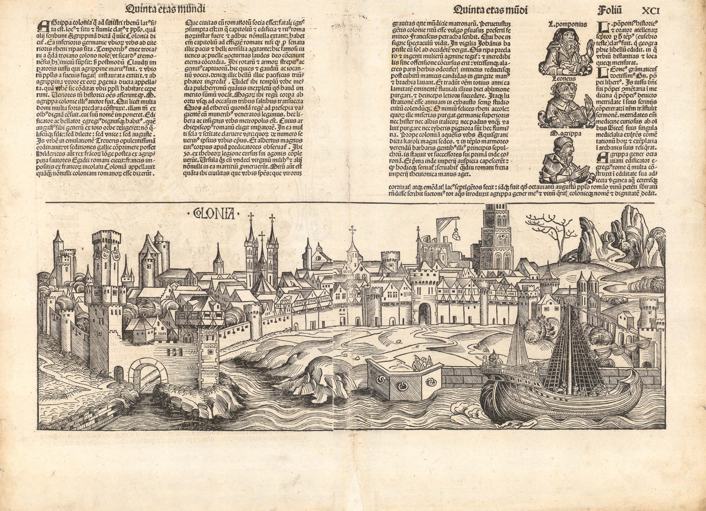
Hartmann Schedel
36 x 53 cm
Incunable woodcut view of the city of Cologne, published in the celebrated Nuremberg Chronicle. The city's great cathedral is shown under construction on the right, and the Rhine flows across the foreground of the map. Unlike many of Schedel's other city views, which were often generic and re-used multiple times, this view of Cologne was drafted specifically and only used once in the atlas. Armorial shields bearing the three crowns of Cologne can be seen on one of the taller towers to the left side of the view. A charming scene in the foreground shows a group of citizens waving farewell to another group aboard a large medieval ship.
The descriptive Latin text above the map roughly translated (and slightly excerpted) reads:
[Left page]
Agrippa Colonia (Cologne), which is situated on the left bank of the Rhine, is highly renowned for its location, its river and its people. Some say it was called Agrippina, but now is called Colonia. It is a city of rich fields in Lower Germany situated next to the banks of the Rhine. According to Sicardus Cremonensis it was founded by and named after Colonus, a Trojan, in the time of the Trojan Aeneas. After the people called the Ubii were driven out by the Suevi (Swabians), the city was built up and taxed by command of Claudius, the Roman emperor, who was the husband of Agrippina. He called the city Agrippa after his wife's family. And so the people called the Ubii began to live there. [...]
Some say the city was a Roman colony. While it was an ally of Rome it was consumed by a destructive fire. It had a Capitol building and other structures, in the Roman manner, of which a few are still at hand. It had a Capitol of the same construction as that of the Romans, except that in place of the senate there (i.e., in Rome) that debates councils of peace and war, here (i.e., in Cologne) highly renowned youths and maidens, in eternal unity, sang nightly praises to God. There (Rome) is the shrieking sound of wheels and weapons and the groans of captive men. Here is quiet and the voices of those who are joyful and telling jokes. And, finally, in that place (Rome) marches war, and in this place (Cologne) marches the triumphant bringer of peace.
In the midst of the city one sees the most beautiful, though incomplete, temple, which they called the Highest. Here lie also the bodies of the Three Holy Kings, brought there in three stages from east to west. And, as we read, they honored the Heavenly King in the manger with gifts. This is a free and archepiscopal capital city. The archbishop is an elector of the Holy Roman Empire, having a vote in the choice of the Roman emperor. [...]
[Right Page]
Also admirable is how much hope and civic-mindedness are there in that city; and how much seriousness the men possess, and how much elegance the women have. Franciscus Petrarch writes of an old custom of the people of Cologne that was especially observed by the common women. At sundown on the Eve of St. John the Baptist an incredible number of women assemble on the banks of the river; and with sleeves rolled up to their elbows, they immerse pleasant smelling herbs in the water, and put their snowy white hands and arms in it, at the same time throwing all the troubles of the year into the water, so that the river may wash them away and bring back happiness instead. Oh, you more than blessed inhabitants of the Rhine, which washes away and cleanses your shortcomings, something which neither the Danube (Hister) nor the Elbe (Albis) in Upper Germany, nor the Po (Padus) in Italy, nor the Tiber ever has the strength to do. These are rather lazy, sluggish rivers! [...]
[GER1971]
- X
- Tumblr
Join our mailing list
* denotes required fields
We will process the personal data you have supplied to communicate with you in accordance with our Privacy Policy. You can unsubscribe or change your preferences at any time by clicking the link in our emails.
Contact
The Map House
54 Beauchamp Place,
London SW3 1NY,
United Kingdom
maps@themaphouse.com
+44 (0)20 7589 4325
![]()
This website uses cookies
This site uses cookies to help make it more useful to you. Please contact us to find out more about our Cookie Policy.
Join our mailing list
* denotes required fields
We will process the personal data you have supplied to communicate with you in accordance with our Privacy Policy. You can unsubscribe or change your preferences at any time by clicking the link in our emails.