- All
- AFRICA
- ▪ Central Africa
- ▪ East Africa
- ▪ North Africa
- ▪ Southern Africa
- ▪ West Africa
- ▪ Atlantic Islands
- AMERICAS
-
▪ United States (USA)
- USA - East
- USA - Midwest
- USA - Northeast
- USA - Southeast
- USA - West & Southwest
- Alabama
- Alaska
- Arizona
- Arkansas
- California
- Colorado
- Connecticut
- Delaware
- Florida
- Georgia
- Hawaii
- Idaho
- Illinois
- Indiana
- Iowa
- Kansas
- Kentucky
- Louisiana
- Maine
- Maryland
- Massachusetts
- Michigan
- Minnesota
- Mississippi
- Missouri
- Montana
- Nebraska
- Nevada
- New Hampshire
- New Jersey
- New Mexico
- New York
- New York City
- North Carolina
- North Dakota
- Ohio
- Oklahoma
- Oregon
- Pennsylvania
- Rhode Island
- South Carolina
- South Dakota
- Tennessee
- Texas
- Utah
- Vermont
- Virginia
- Washington
- Washington, D.C.
- West Virginia
- Wisconsin
- Wyoming
- ▪ North America
- ▪ South America
- ▪ Caribbean
- ASIA
- ▪ East Asia
- ▪ Southeast Asia
- ▪ India & South Asia
- ▪ Middle East & Turkey
- BRITISH ISLES
- ▪ London
-
▪ England
- English Cities
- Bedfordshire
- Berkshire
- Buckinghamshire
- Cambridgeshire
- Cheshire
- Cornwall
- Cumbria
- Derbyshire
- Devon
- Dorset
- Durham
- Essex
- Gloucestershire
- Hampshire
- Herefordshire
- Hertfordshire
- Huntingdonshire
- Isle of Wight
- Kent
- Lancashire
- Leicestershire
- Lincolnshire
- Middlesex
- Norfolk
- Northamptonshire
- Northumberland
- Nottinghamshire
- Oxfordshire
- Rutland
- Shropshire
- Somerset
- Staffordshire
- Suffolk
- Surrey
- Sussex
- Warwickshire
- Wiltshire
- Worcestershire
- Yorkshire
- Yorkshire East Riding
- Yorkshire North Riding
- Yorkshire West Riding
- ▪ Ireland
- ▪ Scotland
- ▪ Wales
- EUROPE
- ▪ Austria & Switzerland
- ▪ Benelux Region
- ▪ Central & Eastern Europe
- ▪ France & Monaco
- ▪ Germany
- ▪ Greece
- ▪ Italy
- ▪ Mediterranean Sea
- ▪ Spain & Portugal
- ▪ Scandinavia & Baltics
- ▪ Russia, Ukraine & Caucasus
- OCEANIA
- ▪ Australia
- ▪ New Zealand
- ▪ Pacific Ocean & Islands
- ▪ Papua New Guinea
- POLAR
- CELESTIAL
- WORLD
- GLOBES & INSTRUMENTS
- THEMATIC
- COLLABORATIONS
Francois Halma
50 x 66 cm
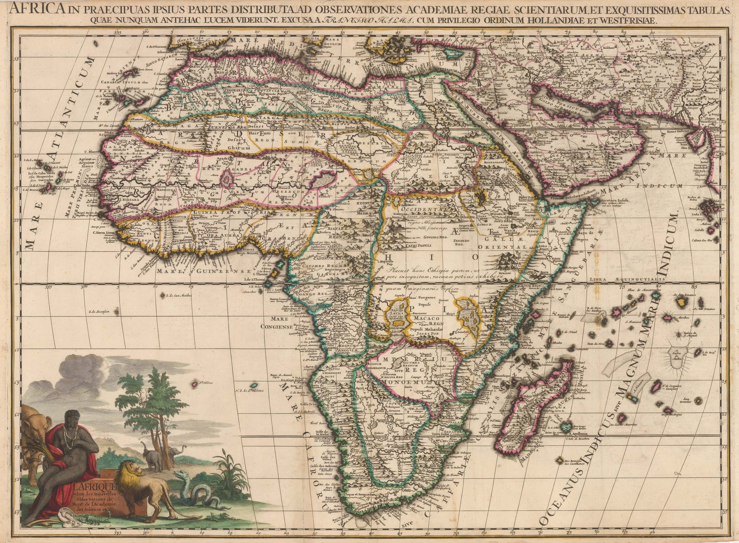
Large, copper engraved map of Africa from the early 18th Century. The map extends to show part of the Mediterranean, the Levant, the Arabian Peninsula and eastwards to show the coast of the Indian subcontinent and the islands of the Maldives.
During the late 17th Century, a French diplomat named N. P. Ablancourt gained access to manuscript maps of the African coastline for publication in the "Neptune Francois" which was published simultaneously by Hubert Jaillot and Pierre Mortier in 1693. This prestigious sea atlas undoubtedly influenced and acted as a source for years to come. However, despite this updated knowledge, there are inaccuracies. One example shown on this map is the curious bulge is shown along the coast of modern-day Namibia - famously known as the "Skeleton Coast" for its shipwrecks.
Like a majority of maps published during this period, this map includes rather fanciful interior detail. There are two mythical lakes of "Zaire" and "Zaflan" in the southern central region that were speculated to be the sources of the great African rivers such as the Nile, Zambesi and Congo. Above the equator in Latin script, there is a note "[in the] above in the kingdom of Abyssinia, exists the true spring of [the] Nile". To further suggest that the interior detail on this map may be incorrect and rather than ignorantly filling in 'terra incognito' with more mythical mapping, another Latin annotation states "it was decided that this part of Ethiopia may be left as unexplained rather than empty".
The physical terrain of the Continent is described with finely engraved illustrations of mountain ranges, stippled deserts and sand banks, sand dunes along the coast, a tangle of lakes and rivers systems. Small icons of buildings are used to mark cities and settlements and occasionally accompanied by an alternative name or notation about the place - ie, "Arkiko, the port which the Turks now hold", "The people who inhabit the shore of this river are called Abosini", and "Mecca, homeland of Prophet Mohammed".
In the lower left of the map, a decorative title cartouche depicting the allegory, Africa, here shown as a black woman, sat surrounded by wild animals including a lion, elephants, a snake, and a scorpion.
This large map is by Francois Halma (1653-1722) was an established Dutch cartographer, publisher and bookseller who worked in Utrecht, Amsterdam and Leeuwarden in Holland.
Original hand colour. [AFR5726]
- X
- Tumblr
Join our mailing list
* denotes required fields
We will process the personal data you have supplied to communicate with you in accordance with our Privacy Policy. You can unsubscribe or change your preferences at any time by clicking the link in our emails.
Contact
The Map House
54 Beauchamp Place,
London SW3 1NY,
United Kingdom
maps@themaphouse.com
+44 (0)20 7589 4325
![]()
This website uses cookies
This site uses cookies to help make it more useful to you. Please contact us to find out more about our Cookie Policy.
Join our mailing list
* denotes required fields
We will process the personal data you have supplied to communicate with you in accordance with our Privacy Policy. You can unsubscribe or change your preferences at any time by clicking the link in our emails.