- All
- AFRICA
- ▪ Central Africa
- ▪ East Africa
- ▪ North Africa
- ▪ Southern Africa
- ▪ West Africa
- ▪ Atlantic Islands
- AMERICAS
-
▪ United States
- USA - East
- USA - Midwest
- USA - Northeast
- USA - Southeast
- USA - West & Southwest
- Alabama
- Alaska
- Arizona
- Arkansas
- California
- Colorado
- Connecticut
- Delaware
- Florida
- Georgia
- Hawaii
- Idaho
- Illinois
- Indiana
- Iowa
- Kansas
- Kentucky
- Louisiana
- Maine
- Maryland
- Massachusetts
- Michigan
- Minnesota
- Mississippi
- Missouri
- Montana
- Nebraska
- Nevada
- New Hampshire
- New Jersey
- New Mexico
- New York
- New York City
- North Carolina
- North Dakota
- Ohio
- Oklahoma
- Oregon
- Pennsylvania
- Rhode Island
- South Carolina
- South Dakota
- Tennessee
- Texas
- Utah
- Vermont
- Virginia
- Washington
- Washington, D.C.
- West Virginia
- Wisconsin
- Wyoming
- ▪ North America
- ▪ South America
- ▪ Caribbean
- ASIA
- ▪ East Asia
- ▪ Southeast Asia
- ▪ India & South Asia
- ▪ Middle East & Turkey
- BRITISH ISLES
- ▪ London
-
▪ England
- English Cities
- Bedfordshire
- Berkshire
- Buckinghamshire
- Cambridgeshire
- Cheshire
- Cornwall
- Cumbria
- Derbyshire
- Devon
- Dorset
- Durham
- Essex
- Gloucestershire
- Hampshire
- Herefordshire
- Hertfordshire
- Huntingdonshire
- Isle of Wight
- Kent
- Lancashire
- Leicestershire
- Lincolnshire
- Middlesex
- Norfolk
- Northamptonshire
- Northumberland
- Nottinghamshire
- Oxfordshire
- Rutland
- Shropshire
- Somerset
- Staffordshire
- Suffolk
- Surrey
- Sussex
- Warwickshire
- Wiltshire
- Worcestershire
- Yorkshire
- Yorkshire East Riding
- Yorkshire North Riding
- Yorkshire West Riding
- ▪ Ireland
- ▪ Scotland
- ▪ Wales
- EUROPE
- ▪ Austria & Switzerland
- ▪ Benelux Region
- ▪ Central & Eastern Europe
- ▪ France & Monaco
- ▪ Germany
- ▪ Greece
- ▪ Italy
- ▪ Mediterranean Sea
- ▪ Spain & Portugal
- ▪ Scandinavia & Baltics
- ▪ Russia, Ukraine & Caucasus
- OCEANIA
- ▪ Australia
- ▪ New Zealand
- ▪ Pacific Ocean & Islands
- ▪ Papua New Guinea
- POLAR
- CELESTIAL
- WORLD
- GLOBES & INSTRUMENTS
- THEMATIC
- COLLABORATIONS
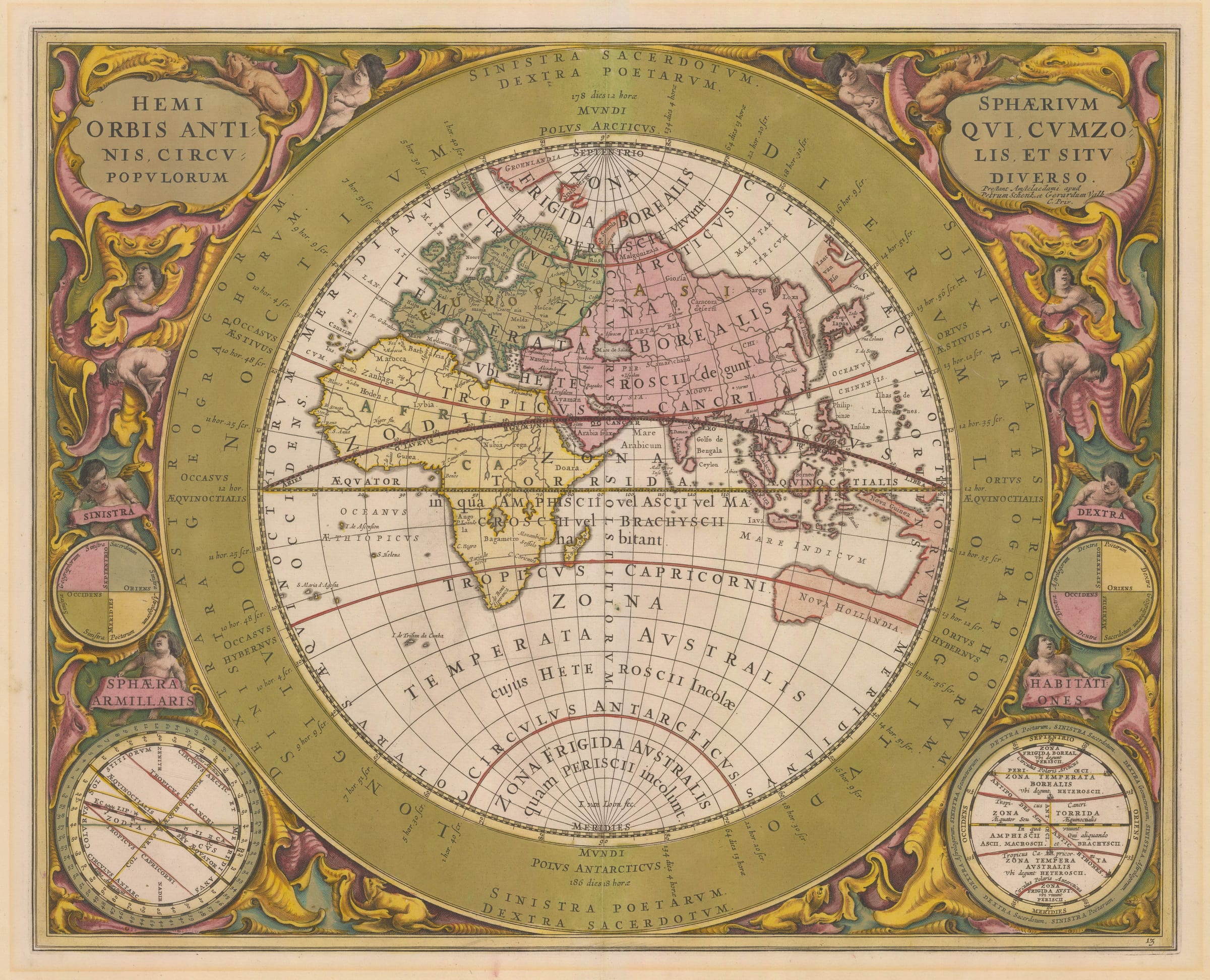
Andreas Cellarius
Hemisphaerium Orbis Antiqui Cumzonis, Circulis et Situ Populorum Diverso, 1661
17 x 21 in
43 x 53 cm
43 x 53 cm
WLD4700
£ 3,750.00
Andreas Cellarius, Hemisphaerium Orbis Antiqui Cumzonis, Circulis et Situ Populorum Diverso, 1661
Sold
%3Cdiv%20class%3D%22artist%22%3EAndreas%20Cellarius%3C/div%3E%3Cdiv%20class%3D%22title_and_year%22%3E%3Cspan%20class%3D%22title_and_year_title%22%3EHemisphaerium%20Orbis%20Antiqui%20Cumzonis%2C%20Circulis%20et%20Situ%20Populorum%20Diverso%3C/span%3E%2C%20%3Cspan%20class%3D%22title_and_year_year%22%3E1661%3C/span%3E%3C/div%3E%3Cdiv%20class%3D%22dimensions%22%3E17%20x%2021%20in%3Cbr/%3E%0A43%20x%2053%20cm%3C/div%3E
The Eastern Hemisphere with the zones of habitation as they were understood by the ancient philosophers. The areas shaded green are the 'Temperate Regions', the central band of yellow is...
The Eastern Hemisphere with the zones of habitation as they were understood by the ancient philosophers. The areas shaded green are the 'Temperate Regions', the central band of yellow is the 'Torrid Region', and the unshaded areas in the north and south are the 'Frigid Regions'. Only the temperate regions were considered hospitable to civilized life by the Classical philosophers.
Cellarius's maps are some of the most decorative ever produced during the Dutch Golden Age and are lauded for their rich, Rococo decoration. This map is no exception. The margins are filled with splendid scrollwork, along with an illustration of an armillary sphere and numerous putti explaining astronomical concepts. While the map's geography is generally accurate, its depiction of Australia (marked on the map as 'Nova Hollandia') is still markedly wrong. This follows the best knowledge available to the cartographers of this era and is based on the exploratory voyages of Dutch sailors.
Sumptuous original hand-colour.
Share
- Tumblr
Join our mailing list
* denotes required fields
We will process the personal data you have supplied to communicate with you in accordance with our Privacy Policy. You can unsubscribe or change your preferences at any time by clicking the link in our emails.
Contact
The Map House
54 Beauchamp Place,
London SW3 1NY,
United Kingdom
maps@themaphouse.com
+44 (0)20 7589 4325
![]()
Copyright © 2024 The Map House
This website uses cookies
This site uses cookies to help make it more useful to you. Please contact us to find out more about our Cookie Policy.