All Maps
- All
- Christmas Gift Ideas
- AFRICA
- ▪ Central Africa
- ▪ East Africa
- ▪ North Africa
- ▪ Southern Africa
- ▪ West Africa
- ▪ Atlantic Islands
- AMERICAS
-
▪ United States (USA)
- USA - East
- USA - Midwest
- USA - Northeast
- USA - Southeast
- USA - West & Southwest
- Alabama
- Alaska
- Arizona
- Arkansas
- California
- Colorado
- Connecticut
- Delaware
- Florida
- Georgia
- Hawaii
- Idaho
- Illinois
- Indiana
- Iowa
- Kansas
- Kentucky
- Louisiana
- Maine
- Maryland
- Massachusetts
- Michigan
- Minnesota
- Mississippi
- Missouri
- Montana
- Nebraska
- Nevada
- New Hampshire
- New Jersey
- New Mexico
- New York
- New York City
- North Carolina
- North Dakota
- Ohio
- Oklahoma
- Oregon
- Pennsylvania
- Rhode Island
- South Carolina
- South Dakota
- Tennessee
- Texas
- Utah
- Vermont
- Virginia
- Washington
- Washington, D.C.
- West Virginia
- Wisconsin
- Wyoming
- ▪ North America
- ▪ South America
- ▪ Caribbean
- ASIA
- ▪ East Asia
- ▪ Southeast Asia
- ▪ India & South Asia
- ▪ Middle East & Turkey
- BRITISH ISLES
- ▪ London
-
▪ England
- English Cities
- Bedfordshire
- Berkshire
- Buckinghamshire
- Cambridgeshire
- Cheshire
- Cornwall
- Cumbria
- Derbyshire
- Devon
- Dorset
- Durham
- Essex
- Gloucestershire
- Hampshire
- Herefordshire
- Hertfordshire
- Huntingdonshire
- Isle of Wight
- Kent
- Lancashire
- Leicestershire
- Lincolnshire
- Middlesex
- Norfolk
- Northamptonshire
- Northumberland
- Nottinghamshire
- Oxfordshire
- Rutland
- Shropshire
- Somerset
- Staffordshire
- Suffolk
- Surrey
- Sussex
- Warwickshire
- Wiltshire
- Worcestershire
- Yorkshire
- Yorkshire East Riding
- Yorkshire North Riding
- Yorkshire West Riding
- ▪ Ireland
- ▪ Scotland
- ▪ Wales
- EUROPE
- ▪ Austria & Switzerland
- ▪ Benelux Region
- ▪ Central & Eastern Europe
- ▪ France & Monaco
- ▪ Germany
- ▪ Greece
- ▪ Italy
- ▪ Mediterranean Sea
- ▪ Spain & Portugal
- ▪ Scandinavia & Baltics
- ▪ Russia, Ukraine & Caucasus
- OCEANIA
- ▪ Australia
- ▪ New Zealand
- ▪ Pacific Ocean & Islands
- ▪ Papua New Guinea
- POLAR
- CELESTIAL
- WORLD
- GLOBES & INSTRUMENTS
- THEMATIC
- COLLABORATIONS
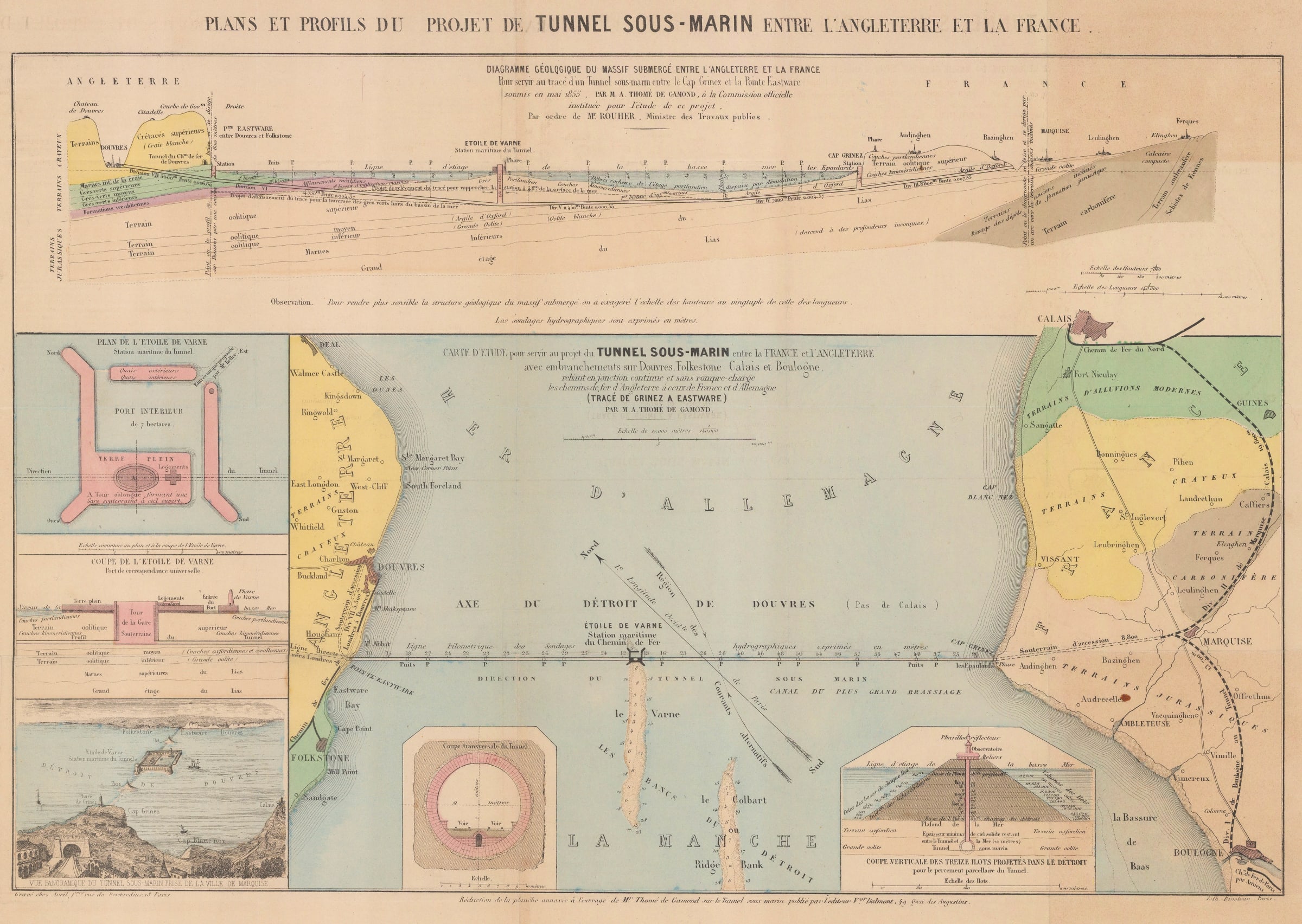
Aimé Thomé de Gamond
33 x 46 cm
A rare and fascinating map illustrating one of the earliest plans for a railway tunnel connecting England and France beneath the English Channel.
This particular plan was proposed by the visionary French railway engineer Aimé Thomé de Gamond to Emperor Napoleon III in 1856. At a cost of just over £7 million, the scheme envisioned a 3.5 mile tunnel from Cap Gris-Nez near Calais to Eastware, just south of Dover (the modern-day Channel Tunnel follows a very similar route, but ends slightly further north on the French side). Halfway across the Channel, a large island was to be constructed housing a lighthouse, observation tower, and an enormous dock for loading and unloading ships bound for both France and England. An enormous tower with a gently sloping spiral ramp, 284 feet in height, would allow pedestrians to visit the island from the tunnel, and would allow railway carriages and hand carts to transport goods from the docks above down to the railway. The entire tunnel was to be lit by so many electric lights that "The traveller descending the immense tower from l'Etoile de Varne, or the station of the submarine railway, would find himself in a region of perpetual day" (New York Times: August 7th, 1866).
Thomé de Gamond's first proposals for a Channel Tunnel appeared in 1834, but only after decades of surveys did he select this route over three other contenders. Gamond conducted numerous highly dangerous underwater geological surveys of the route using rudimentary diving equipment, a testament to his bravery and dedication to the project.
Regrettably, this same enthusiasm for the scheme drove Gamond into bankruptcy after he poured all of his money into the venture. Despite gaining the approval of both Emperor Napoleon III and Queen Victoria, heightened political tension surrounding the Franco-Prussian War led to the abandonment of the project. Gamond died penniless in 1876 and his Channel Tunnel plans were quickly forgotten.
A New York Times article of 1866 judged the project thus:
"the plan of converting our island into a peninsula by means of a submarine isthmus is one within the range of the engineering science and mechanical applications of the present day. The grave and practical question, 'Will it pay?' involves the consideration of other and totally different questions."
Ultimately, it would be more than a century before that question could be answered.
Printed colour. [GB2090]
- X
- Tumblr
Join our mailing list
* denotes required fields
We will process the personal data you have supplied to communicate with you in accordance with our Privacy Policy. You can unsubscribe or change your preferences at any time by clicking the link in our emails.
Contact
The Map House
54 Beauchamp Place,
London SW3 1NY,
United Kingdom
maps@themaphouse.com
+44 (0)20 7589 4325
![]()
This website uses cookies
This site uses cookies to help make it more useful to you. Please contact us to find out more about our Cookie Policy.
Join our mailing list
* denotes required fields
We will process the personal data you have supplied to communicate with you in accordance with our Privacy Policy. You can unsubscribe or change your preferences at any time by clicking the link in our emails.