Close

Search Inventory

Maps
Prints
Keyword
Sort
Categories
Year range
-
Purchase options
Width range
Height range
Submit
The Map House company logo
The Map House
Skip to main content
  • Menu
  • Maps
  • Prints
  • Globes
  • New In
  • Resources
  • Events
  • News
  • Contact
Cart
0 items £
Checkout

Item added to cart

View cart & checkout
Continue shopping
Wishlist
0

This item has been saved to your enquiry list

You can either review your list and make an enquiry, or continue to browse and find other artworks.
View list
Continue browsing
Menu
Maps
Our entire inventory of over 10,000 antique and vintage maps is now available to browse by region, date, cartographer, and subject

All Maps

  • All
  • AFRICA
  • ▪ Central Africa
    • Angola
    • Cameroon & Gabon
    • Chad
    • Congo
  • ▪ East Africa
    • Ethiopia, Eritrea & Djibouti
    • Kenya
    • Somalia
    • Sudan
    • Tanzania
    • Uganda, Rwanda & Burundi
  • ▪ North Africa
    • Algeria
    • Egypt
    • Libya
    • Morocco
    • Tunisia
  • ▪ Southern Africa
    • Botswana
    • Madagascar
    • Malawi
    • Mozambique
    • Namibia
    • South Africa
    • Zambia & Zimbabwe
  • ▪ West Africa
    • Cote d'Ivoire
    • Ghana, Benin & Togo
    • Liberia
    • Mali, Niger & Burkina Faso
    • Nigeria
    • Senegal, Gambia & Guinea
    • Sierra Leone
  • ▪ Atlantic Islands
  • AMERICAS
    • Atlantic Ocean
    • Pacific Ocean
  • ▪ United States (USA)
    • USA - East
    • USA - Midwest
    • USA - Northeast
    • USA - Southeast
    • USA - West & Southwest
    • Alabama
    • Alaska
    • Arizona
    • Arkansas
    • California
    • Colorado
    • Connecticut
    • Delaware
    • Florida
    • Georgia
    • Hawaii
    • Idaho
    • Illinois
    • Indiana
    • Iowa
    • Kansas
    • Kentucky
    • Louisiana
    • Maine
    • Maryland
    • Massachusetts
    • Michigan
    • Minnesota
    • Mississippi
    • Missouri
    • Montana
    • Nebraska
    • Nevada
    • New Hampshire
    • New Jersey
    • New Mexico
    • New York
    • New York City
    • North Carolina
    • North Dakota
    • Ohio
    • Oklahoma
    • Oregon
    • Pennsylvania
    • Rhode Island
    • South Carolina
    • South Dakota
    • Tennessee
    • Texas
    • Utah
    • Vermont
    • Virginia
    • Washington
    • Washington, D.C.
    • West Virginia
    • Wisconsin
    • Wyoming
  • ▪ North America
    • Canada
    • Newfoundland & the Maritimes
    • Northern Canada
    • Ontario & Quebec
    • Western Canada
    • Mexico
    • Central America
  • ▪ South America
    • Argentina
    • Bolivia
    • Brazil
    • Chile
    • Colombia
    • Ecuador
    • Falkland Islands
    • Guianas
    • Paraguay
    • Patagonia
    • Peru
    • Uruguay
    • Venezuela
  • ▪ Caribbean
    • Antigua & Barbuda
    • Aruba, Bonaire & Curacao
    • Bahamas
    • Barbados
    • Bermuda
    • Cayman Islands
    • Cuba
    • Dominica
    • Grenada
    • Guadeloupe
    • Haiti & Dominican Rep.
    • Jamaica
    • Martinique
    • Puerto Rico
    • St Kitts & Nevis
    • St Lucia
    • St Vincent & the Grenadines
    • Trinidad & Tobago
    • Turks & Caicos
    • Virgin Islands
  • ASIA
    • Central Asia & Siberia
  • ▪ East Asia
    • China
    • China Regional
    • Beijing
    • Shanghai
    • Hong Kong
    • Tibet
    • Japan
    • Korea
    • Taiwan
  • ▪ Southeast Asia
    • Burma / Myanmar
    • Cambodia, Laos & Vietnam
    • Indonesia & Borneo
    • Malaysia
    • Philippines
    • Singapore
    • Thailand
  • ▪ India & South Asia
    • Afghanistan
    • India
    • India Cities
    • India Regional
    • Indian Ocean & Islands
    • Nepal, Bhutan & Himalayas
    • Pakistan
    • Punjab & Sikh Empire
    • Sri Lanka / Ceylon
  • ▪ Middle East & Turkey
    • Arabia
    • Saudi & Gulf States
    • Iran / Persia
    • Iraq / Mesopotamia
    • Jerusalem
    • Levant / Holy Land
    • Oman & Yemen
    • Turkey
    • Istanbul / Constantinople
  • BRITISH ISLES
    • British Sea Charts
    • British Geological Maps
    • Channel Islands
    • Isle of Man
  • ▪ London
    • Underground & Transport
    • Central London & The City
    • East London
    • North & Northwest London
    • Southeast London
    • West & Southwest London
  • ▪ England
    • English Cities
    • Bedfordshire
    • Berkshire
    • Buckinghamshire
    • Cambridgeshire
    • Cheshire
    • Cornwall
    • Cumbria
    • Derbyshire
    • Devon
    • Dorset
    • Durham
    • Essex
    • Gloucestershire
    • Hampshire
    • Herefordshire
    • Hertfordshire
    • Huntingdonshire
    • Isle of Wight
    • Kent
    • Lancashire
    • Leicestershire
    • Lincolnshire
    • Middlesex
    • Norfolk
    • Northamptonshire
    • Northumberland
    • Nottinghamshire
    • Oxfordshire
    • Rutland
    • Shropshire
    • Somerset
    • Staffordshire
    • Suffolk
    • Surrey
    • Sussex
    • Warwickshire
    • Wiltshire
    • Worcestershire
    • Yorkshire
    • Yorkshire East Riding
    • Yorkshire North Riding
    • Yorkshire West Riding
  • ▪ Ireland
    • Dublin
    • N. Ireland / Ulster
    • Rep. of Ireland Counties
    • Rep. of Ireland Cities
  • ▪ Scotland
    • Edinburgh
    • Glasgow
    • Scotland Regional
    • Shetland, Orkney & Hebrides
  • ▪ Wales
    • North Wales
    • South Wales
    • Anglesey
    • Breconshire
    • Cardiganshire
    • Carmarthenshire
    • Caernarfonshire
    • Denbighshire
    • Flintshire
    • Cardiff & Glamorgan
    • Merionethshire
    • Monmouthshire
    • Montgomeryshire
    • Pembrokeshire
    • Radnorshire
  • EUROPE
  • ▪ Austria & Switzerland
    • Austria
    • Switzerland
    • Switzerland - Cities
    • The Alps
  • ▪ Benelux Region
    • Belgium
    • Luxembourg
    • Netherlands
    • Netherlands - Cities
  • ▪ Central & Eastern Europe
    • Balkans
    • Belarus
    • Bulgaria
    • Croatia
    • Czech Rep. & Slovakia
    • Hungary
    • Poland
    • Romania & Transylvania
  • ▪ France & Monaco
    • France
    • Paris
    • French Wine Maps
    • French Cities
    • French Regions
    • Provence & Cote d'Azur
    • Monaco
  • ▪ Germany
    • German Cities
    • German Regions
    • Prussia
  • ▪ Greece
    • Greek Islands
  • ▪ Italy
    • Italian Cities
    • Northern Italy
    • Tuscany & Central Italy
    • Southern Italy & Sicily
  • ▪ Mediterranean Sea
    • Corsica
    • Cyprus
    • Elba
    • Malta
    • Sardinia
  • ▪ Spain & Portugal
    • Spain
    • Spain - Regional
    • Spain - Cities
    • Balearic Islands
    • Gibraltar
    • Portugal
  • ▪ Scandinavia & Baltics
    • Baltic States
    • Denmark
    • Finland
    • Iceland & Greenland
    • Norway
    • Sweden
  • ▪ Russia, Ukraine & Caucasus
    • Russia
    • Asiatic Russia / Siberia
    • European Russia
    • Russian Cities
    • Caucasus & Caspian Sea
    • Ukraine, Black Sea & Crimea
  • OCEANIA
  • ▪ Australia
    • Sydney
    • New South Wales
    • Northern Territory
    • Queensland
    • South Australia
    • Tasmania
    • Victoria
    • Western Australia
  • ▪ New Zealand
  • ▪ Pacific Ocean & Islands
  • ▪ Papua New Guinea
  • POLAR
    • Antarctica
    • The Arctic
    • Polar World Maps
  • CELESTIAL
    • Celestial Maps
    • The Moon & Planets
  • WORLD
    • World Maps
    • Thematic World Maps
    • World & Continent Sets
    • Title Pages
    • Portolan Charts
  • GLOBES & INSTRUMENTS
    • Terrestrial Globes
    • Celestial & Moon Globes
    • Pairs of Globes
    • Scientific Instruments
  • THEMATIC
    • Island of California
    • Commodities & Trade
    • Noted Explorers
    • Geological
    • Historical
    • Infographics
    • Oceanography
    • Pictorial
    • Posters
    • Sea Charts
    • Space Age
    • Republic of Texas
    • Transport
    • War Maps
  • COLLABORATIONS
    • Adam Dant
    • Kristjana S. Williams
    • Justine Smith
Open a larger version of the following image in a popup: Sampson Low, Marston & Company, The "District Map" of Greater London and Environs - 1st Edition, 1902

Sampson Low, Marston & Company

The "District Map" of Greater London and Environs - 1st Edition, 1902
25 ½ x 41 ½ in
65 x 105 cm
LDN6948
£ 400.00
Sampson Low, Marston & Company, The "District Map" of Greater London and Environs - 1st Edition, 1902
Sold
Enquire
%3Cdiv%20class%3D%22artist%22%3ESampson%20Low%2C%20Marston%20%26%20Company%3C/div%3E%3Cdiv%20class%3D%22title_and_year%22%3E%3Cspan%20class%3D%22title_and_year_title%22%3EThe%20%22District%20Map%22%20of%20Greater%20London%20and%20Environs%20-%201st%20Edition%3C/span%3E%2C%20%3Cspan%20class%3D%22title_and_year_year%22%3E1902%3C/span%3E%3C/div%3E%3Cdiv%20class%3D%22dimensions%22%3E25%20%C2%BD%20x%2041%20%C2%BD%20in%3Cbr/%3E%0A65%20x%20105%20cm%3C/div%3E
Save
Remove
View on a Wall
Starting in 1874, the District Line began issuing maps under its own branding for the first time - the 'Improved District Railway Map of London'. These pamphlet maps were still...
View full details
Starting in 1874, the District Line began issuing maps under its own branding for the first time - the "Improved District Railway Map of London". These pamphlet maps were still almost a meter wide when fully unfolded, but improved colour printing and increased emphasis on the Underground lines make these maps far more readable than any of their predecessors. As the District Railway expanded further outside of Central London, a new map was needed to help travellers reach these new stations. Building on the success of their Improved District Railway Map series, the District Railway began issuing a companion map of Greater London.

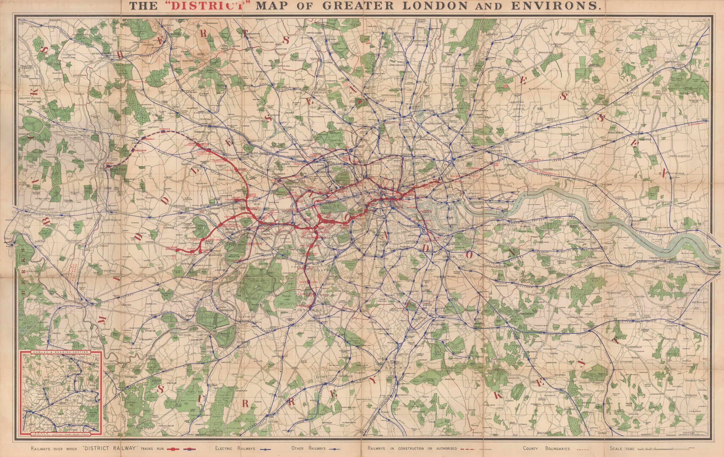
Extending from Windsor in the west to Northfleet in the east, this map allowed the full extent of the capital’s railways to be put on show, with extra emphasis given, of course, to lines operated by the District Railway, which are drawn in bright red. Solid lines indicated railways in operation, while dotted lines show routes which are still under construction. The western extension of the District Line from South Harrow to Uxbridge is one of the lines shown as authorized but not yet constructed. This section of track would not open until March 1910. Hounslow Barracks, now Hounslow West on the Piccadilly Line, marks the western edge of District Railway services at this time. Services to Wimbledon and Richmond are both underway, as are East London services to New Cross and East Ham.

Printed colour. Folded. [LDN6948]
Close full details
Share
  • Facebook
  • X
  • Pinterest
  • Tumblr
  • Email
Previous
|
Next
8366 
of  10439

Join our mailing list

Submit

* denotes required fields

We will process the personal data you have supplied to communicate with you in accordance with our Privacy Policy. You can unsubscribe or change your preferences at any time by clicking the link in our emails.

Contact

The Map House

54 Beauchamp Place,
London SW3 1NY,

United Kingdom


maps@themaphouse.com
+44 (0)20 7589 4325

Shipping

Privacy

Contact

Framing

We Buy Maps

Instagram, opens in a new tab.
Twitter, opens in a new tab.
Facebook, opens in a new tab.
Youtube, opens in a new tab.
Privacy Policy
Manage cookies
Copyright © 2025 The Map House
Site by Artlogic

This website uses cookies
This site uses cookies to help make it more useful to you. Please contact us to find out more about our Cookie Policy.

Manage cookies
Accept

Cookie preferences

Check the boxes for the cookie categories you allow our site to use

Cookie options
Required for the website to function and cannot be disabled.
Improve your experience on the website by storing choices you make about how it should function.
Allow us to collect anonymous usage data in order to improve the experience on our website.
Allow us to identify our visitors so that we can offer personalised, targeted marketing.
Save preferences
Close

Join our mailing list

Submit

* denotes required fields

We will process the personal data you have supplied to communicate with you in accordance with our Privacy Policy. You can unsubscribe or change your preferences at any time by clicking the link in our emails.