Close

Search Inventory

Maps
Prints
Keyword
Sort
Categories
Year range
-
Purchase options
Width range
Height range
Submit
The Map House company logo
The Map House
Skip to main content
  • Menu
  • Maps
  • Prints
  • Globes
  • New In
  • Resources
  • Events
  • News
  • Contact
Cart
0 items £
Checkout

Item added to cart

View cart & checkout
Continue shopping
Wishlist
0

This item has been saved to your enquiry list

You can either review your list and make an enquiry, or continue to browse and find other artworks.
View list
Continue browsing
Menu
Maps
Our entire inventory of over 10,000 antique and vintage maps is now available to browse by region, date, cartographer, and subject

All Maps

  • All
  • AFRICA
  • ▪ Central Africa
    • Angola
    • Cameroon & Gabon
    • Chad
    • Congo
  • ▪ East Africa
    • Ethiopia, Eritrea & Djibouti
    • Kenya
    • Somalia
    • Sudan
    • Tanzania
    • Uganda, Rwanda & Burundi
  • ▪ North Africa
    • Algeria
    • Egypt
    • Libya
    • Morocco
    • Tunisia
  • ▪ Southern Africa
    • Botswana
    • Madagascar
    • Malawi
    • Mozambique
    • Namibia
    • South Africa
    • Zambia & Zimbabwe
  • ▪ West Africa
    • Cote d'Ivoire
    • Ghana, Benin & Togo
    • Liberia
    • Mali, Niger & Burkina Faso
    • Nigeria
    • Senegal, Gambia & Guinea
    • Sierra Leone
  • ▪ Atlantic Islands
  • AMERICAS
    • Atlantic Ocean
    • Pacific Ocean
  • ▪ United States (USA)
    • USA - East
    • USA - Midwest
    • USA - Northeast
    • USA - Southeast
    • USA - West & Southwest
    • Alabama
    • Alaska
    • Arizona
    • Arkansas
    • California
    • Colorado
    • Connecticut
    • Delaware
    • Florida
    • Georgia
    • Hawaii
    • Idaho
    • Illinois
    • Indiana
    • Iowa
    • Kansas
    • Kentucky
    • Louisiana
    • Maine
    • Maryland
    • Massachusetts
    • Michigan
    • Minnesota
    • Mississippi
    • Missouri
    • Montana
    • Nebraska
    • Nevada
    • New Hampshire
    • New Jersey
    • New Mexico
    • New York
    • New York City
    • North Carolina
    • North Dakota
    • Ohio
    • Oklahoma
    • Oregon
    • Pennsylvania
    • Rhode Island
    • South Carolina
    • South Dakota
    • Tennessee
    • Texas
    • Utah
    • Vermont
    • Virginia
    • Washington
    • Washington, D.C.
    • West Virginia
    • Wisconsin
    • Wyoming
  • ▪ North America
    • Canada
    • Newfoundland & the Maritimes
    • Northern Canada
    • Ontario & Quebec
    • Western Canada
    • Mexico
    • Central America
  • ▪ South America
    • Argentina
    • Bolivia
    • Brazil
    • Chile
    • Colombia
    • Ecuador
    • Falkland Islands
    • Guianas
    • Paraguay
    • Patagonia
    • Peru
    • Uruguay
    • Venezuela
  • ▪ Caribbean
    • Antigua & Barbuda
    • Aruba, Bonaire & Curacao
    • Bahamas
    • Barbados
    • Bermuda
    • Cayman Islands
    • Cuba
    • Dominica
    • Grenada
    • Guadeloupe
    • Haiti & Dominican Rep.
    • Jamaica
    • Martinique
    • Puerto Rico
    • St Kitts & Nevis
    • St Lucia
    • St Vincent & the Grenadines
    • Trinidad & Tobago
    • Turks & Caicos
    • Virgin Islands
  • ASIA
    • Central Asia & Siberia
  • ▪ East Asia
    • China
    • China Regional
    • Beijing
    • Shanghai
    • Hong Kong
    • Tibet
    • Japan
    • Korea
    • Taiwan
  • ▪ Southeast Asia
    • Burma / Myanmar
    • Cambodia, Laos & Vietnam
    • Indonesia & Borneo
    • Malaysia
    • Philippines
    • Singapore
    • Thailand
  • ▪ India & South Asia
    • Afghanistan
    • India
    • India Cities
    • India Regional
    • Indian Ocean & Islands
    • Nepal, Bhutan & Himalayas
    • Pakistan
    • Punjab & Sikh Empire
    • Sri Lanka / Ceylon
  • ▪ Middle East & Turkey
    • Arabia
    • Saudi & Gulf States
    • Iran / Persia
    • Iraq / Mesopotamia
    • Jerusalem
    • Levant / Holy Land
    • Oman & Yemen
    • Turkey
    • Istanbul / Constantinople
  • BRITISH ISLES
    • British Sea Charts
    • British Geological Maps
    • Channel Islands
    • Isle of Man
  • ▪ London
    • Underground & Transport
    • Central London & The City
    • East London
    • North & Northwest London
    • Southeast London
    • West & Southwest London
  • ▪ England
    • English Cities
    • Bedfordshire
    • Berkshire
    • Buckinghamshire
    • Cambridgeshire
    • Cheshire
    • Cornwall
    • Cumbria
    • Derbyshire
    • Devon
    • Dorset
    • Durham
    • Essex
    • Gloucestershire
    • Hampshire
    • Herefordshire
    • Hertfordshire
    • Huntingdonshire
    • Isle of Wight
    • Kent
    • Lancashire
    • Leicestershire
    • Lincolnshire
    • Middlesex
    • Norfolk
    • Northamptonshire
    • Northumberland
    • Nottinghamshire
    • Oxfordshire
    • Rutland
    • Shropshire
    • Somerset
    • Staffordshire
    • Suffolk
    • Surrey
    • Sussex
    • Warwickshire
    • Wiltshire
    • Worcestershire
    • Yorkshire
    • Yorkshire East Riding
    • Yorkshire North Riding
    • Yorkshire West Riding
  • ▪ Ireland
    • Dublin
    • N. Ireland / Ulster
    • Rep. of Ireland Counties
    • Rep. of Ireland Cities
  • ▪ Scotland
    • Edinburgh
    • Glasgow
    • Scotland Regional
    • Shetland, Orkney & Hebrides
  • ▪ Wales
    • North Wales
    • South Wales
    • Anglesey
    • Breconshire
    • Cardiganshire
    • Carmarthenshire
    • Caernarfonshire
    • Denbighshire
    • Flintshire
    • Cardiff & Glamorgan
    • Merionethshire
    • Monmouthshire
    • Montgomeryshire
    • Pembrokeshire
    • Radnorshire
  • EUROPE
  • ▪ Austria & Switzerland
    • Austria
    • Switzerland
    • Switzerland - Cities
    • The Alps
  • ▪ Benelux Region
    • Belgium
    • Luxembourg
    • Netherlands
    • Netherlands - Cities
  • ▪ Central & Eastern Europe
    • Balkans
    • Belarus
    • Bulgaria
    • Croatia
    • Czech Rep. & Slovakia
    • Hungary
    • Poland
    • Romania & Transylvania
  • ▪ France & Monaco
    • France
    • Paris
    • French Wine Maps
    • French Cities
    • French Regions
    • Provence & Cote d'Azur
    • Monaco
  • ▪ Germany
    • German Cities
    • German Regions
    • Prussia
  • ▪ Greece
    • Greek Islands
  • ▪ Italy
    • Italian Cities
    • Northern Italy
    • Tuscany & Central Italy
    • Southern Italy & Sicily
  • ▪ Mediterranean Sea
    • Corsica
    • Cyprus
    • Elba
    • Malta
    • Sardinia
  • ▪ Spain & Portugal
    • Spain
    • Spain - Regional
    • Spain - Cities
    • Balearic Islands
    • Gibraltar
    • Portugal
  • ▪ Scandinavia & Baltics
    • Baltic States
    • Denmark
    • Finland
    • Iceland & Greenland
    • Norway
    • Sweden
  • ▪ Russia, Ukraine & Caucasus
    • Russia
    • Asiatic Russia / Siberia
    • European Russia
    • Russian Cities
    • Caucasus & Caspian Sea
    • Ukraine, Black Sea & Crimea
  • OCEANIA
  • ▪ Australia
    • Sydney
    • New South Wales
    • Northern Territory
    • Queensland
    • South Australia
    • Tasmania
    • Victoria
    • Western Australia
  • ▪ New Zealand
  • ▪ Pacific Ocean & Islands
  • ▪ Papua New Guinea
  • POLAR
    • Antarctica
    • The Arctic
    • Polar World Maps
  • CELESTIAL
    • Celestial Maps
    • The Moon & Planets
  • WORLD
    • World Maps
    • Thematic World Maps
    • World & Continent Sets
    • Title Pages
    • Portolan Charts
  • GLOBES & INSTRUMENTS
    • Terrestrial Globes
    • Celestial & Moon Globes
    • Pairs of Globes
    • Scientific Instruments
  • THEMATIC
    • Island of California
    • Commodities & Trade
    • Noted Explorers
    • Geological
    • Historical
    • Infographics
    • Oceanography
    • Pictorial
    • Posters
    • Sea Charts
    • Space Age
    • Republic of Texas
    • Transport
    • War Maps
  • COLLABORATIONS
    • Adam Dant
    • Kristjana S. Williams
    • Justine Smith
Open a larger version of the following image in a popup: W. & A.K. Johnston, Map of Eastern Equatorial Africa, 1864

W. & A.K. Johnston

Map of Eastern Equatorial Africa, 1864
21 ½ x 16 in
54 x 41 cm
AFR6259
£ 975.00
W. & A.K. Johnston, Map of Eastern Equatorial Africa, 1864
Sold
Enquire
%3Cdiv%20class%3D%22artist%22%3EW.%20%26%20A.K.%20Johnston%3C/div%3E%3Cdiv%20class%3D%22title_and_year%22%3E%3Cspan%20class%3D%22title_and_year_title%22%3EMap%20of%20Eastern%20Equatorial%20Africa%3C/span%3E%2C%20%3Cspan%20class%3D%22title_and_year_year%22%3E1864%3C/span%3E%3C/div%3E%3Cdiv%20class%3D%22dimensions%22%3E21%20%C2%BD%20x%2016%20in%3Cbr/%3E%0A54%20x%2041%20cm%3C/div%3E
Save
Remove
View on a Wall
Speke’s map of East Africa chronicling his journeys in search of the source for the Nile, through modern Tanzania, Rwanda, Burundi, Uganda and South Sudan. This is the map Speke...
View full details
Speke’s map of East Africa chronicling his journeys in search of the source for the Nile, through modern Tanzania, Rwanda, Burundi, Uganda and South Sudan.

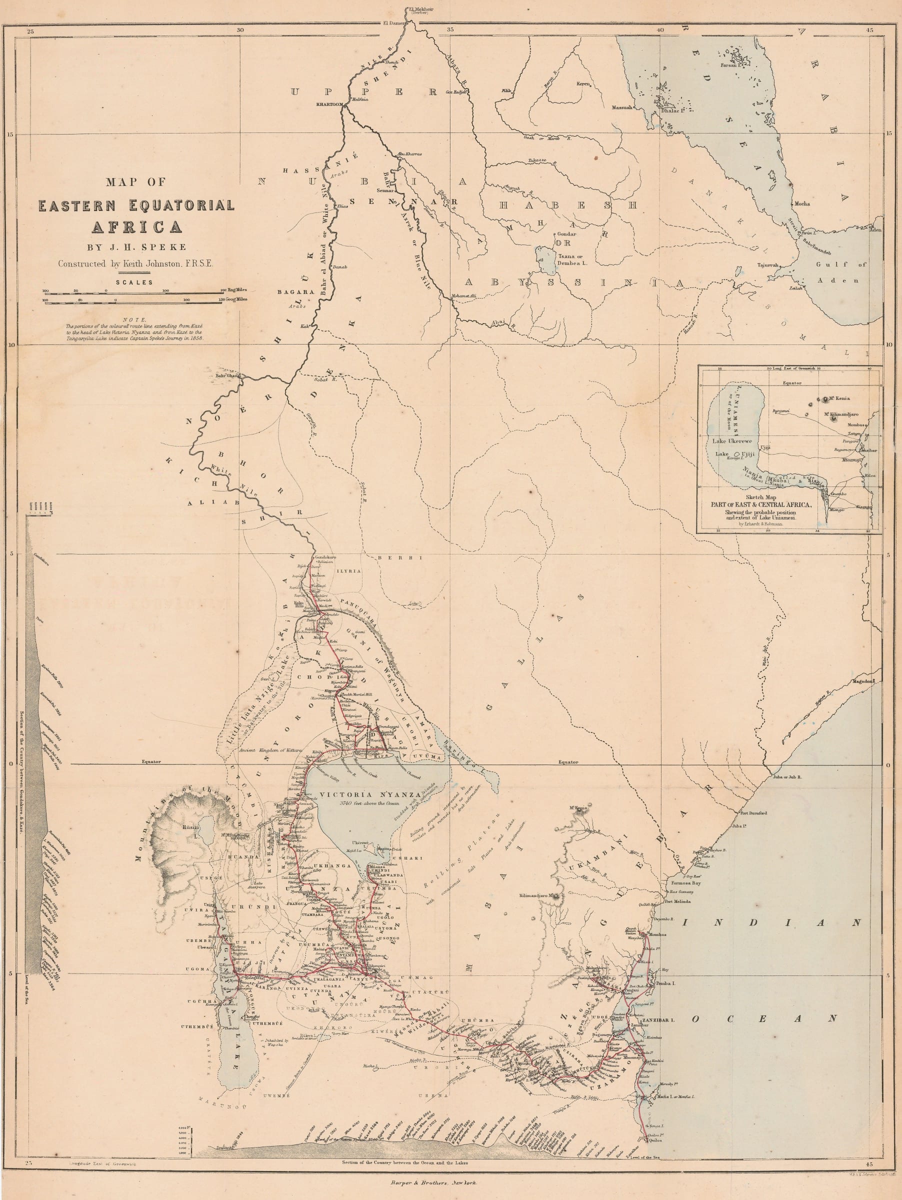
This is the map Speke compiled to illustrate his search for the source of the Nile. It was first issued in 1863 after Speke and Grant’s return as Speke triumphantly declared that he had proved his theory that the Nile had its source in Lake Victoria. He had been contracted by William Blackwood and Sons, the publisher, to write an account of his epic journey. The publishers wanted to take advantage of his fame, hence the rather hurried and schematic nature of the map. It has little detail with the exception of Speke and Grant’s route in red, together with the details of the settlements where they stopped.

A small note below the title briefly mentions Speke’s earlier 1858 journey from the settlement of Kaze (modern Tabora) to Lake Tanganyika, which he made with Sir Richard Burton. Not mentioned is another side trip which Speke made in his 1858 expedition, again from Tabora to Muanza (modern Mwanza) on the southern shores of Lake Victoria. It was this side trip that inspired Speke with his conviction that Lake Victoria was the source of the Nile and which drove him to organize a second expedition, this time with James Grant, to prove his theory.

The route is seen as finishing in Gondokoro, South Sudan. The map was expertly engraved by one of the foremost cartographic firms of their day, W. and A.K. Johnston of Edinburgh.

This example is the first American edition published by Harper Brothers in 1864.

Original colour. [AFR6259]
Close full details
Share
  • Facebook
  • X
  • Pinterest
  • Tumblr
  • Email
Previous
|
Next
6641 
of  10429

Join our mailing list

Submit

* denotes required fields

We will process the personal data you have supplied to communicate with you in accordance with our Privacy Policy. You can unsubscribe or change your preferences at any time by clicking the link in our emails.

Contact

The Map House

54 Beauchamp Place,
London SW3 1NY,

United Kingdom


maps@themaphouse.com
+44 (0)20 7589 4325

Shipping

Privacy

Contact

Framing

We Buy Maps

Instagram, opens in a new tab.
Twitter, opens in a new tab.
Facebook, opens in a new tab.
Youtube, opens in a new tab.
Privacy Policy
Manage cookies
Copyright © 2025 The Map House
Site by Artlogic

This website uses cookies
This site uses cookies to help make it more useful to you. Please contact us to find out more about our Cookie Policy.

Manage cookies
Accept

Cookie preferences

Check the boxes for the cookie categories you allow our site to use

Cookie options
Required for the website to function and cannot be disabled.
Improve your experience on the website by storing choices you make about how it should function.
Allow us to collect anonymous usage data in order to improve the experience on our website.
Allow us to identify our visitors so that we can offer personalised, targeted marketing.
Save preferences
Close

Join our mailing list

Submit

* denotes required fields

We will process the personal data you have supplied to communicate with you in accordance with our Privacy Policy. You can unsubscribe or change your preferences at any time by clicking the link in our emails.