All Maps
- All
- AFRICA
- ▪ Central Africa
- ▪ East Africa
- ▪ North Africa
- ▪ Southern Africa
- ▪ West Africa
- ▪ Atlantic Islands
- AMERICAS
-
▪ United States (USA)
- USA - East
- USA - Midwest
- USA - Northeast
- USA - Southeast
- USA - West & Southwest
- Alabama
- Alaska
- Arizona
- Arkansas
- California
- Colorado
- Connecticut
- Delaware
- Florida
- Georgia
- Hawaii
- Idaho
- Illinois
- Indiana
- Iowa
- Kansas
- Kentucky
- Louisiana
- Maine
- Maryland
- Massachusetts
- Michigan
- Minnesota
- Mississippi
- Missouri
- Montana
- Nebraska
- Nevada
- New Hampshire
- New Jersey
- New Mexico
- New York
- New York City
- North Carolina
- North Dakota
- Ohio
- Oklahoma
- Oregon
- Pennsylvania
- Rhode Island
- South Carolina
- South Dakota
- Tennessee
- Texas
- Utah
- Vermont
- Virginia
- Washington
- Washington, D.C.
- West Virginia
- Wisconsin
- Wyoming
- ▪ North America
- ▪ South America
- ▪ Caribbean
- ASIA
- ▪ East Asia
- ▪ Southeast Asia
- ▪ India & South Asia
- ▪ Middle East & Turkey
- BRITISH ISLES
- ▪ London
-
▪ England
- English Cities
- Bedfordshire
- Berkshire
- Buckinghamshire
- Cambridgeshire
- Cheshire
- Cornwall
- Cumbria
- Derbyshire
- Devon
- Dorset
- Durham
- Essex
- Gloucestershire
- Hampshire
- Herefordshire
- Hertfordshire
- Huntingdonshire
- Isle of Wight
- Kent
- Lancashire
- Leicestershire
- Lincolnshire
- Middlesex
- Norfolk
- Northamptonshire
- Northumberland
- Nottinghamshire
- Oxfordshire
- Rutland
- Shropshire
- Somerset
- Staffordshire
- Suffolk
- Surrey
- Sussex
- Warwickshire
- Wiltshire
- Worcestershire
- Yorkshire
- Yorkshire East Riding
- Yorkshire North Riding
- Yorkshire West Riding
- ▪ Ireland
- ▪ Scotland
- ▪ Wales
- EUROPE
- ▪ Austria & Switzerland
- ▪ Benelux Region
- ▪ Central & Eastern Europe
- ▪ France & Monaco
- ▪ Germany
- ▪ Greece
- ▪ Italy
- ▪ Mediterranean Sea
- ▪ Spain & Portugal
- ▪ Scandinavia & Baltics
- ▪ Russia, Ukraine & Caucasus
- OCEANIA
- ▪ Australia
- ▪ New Zealand
- ▪ Pacific Ocean & Islands
- ▪ Papua New Guinea
- POLAR
- CELESTIAL
- WORLD
- GLOBES & INSTRUMENTS
- THEMATIC
- COLLABORATIONS
Hippolyte Balliere
62 x 50 cm
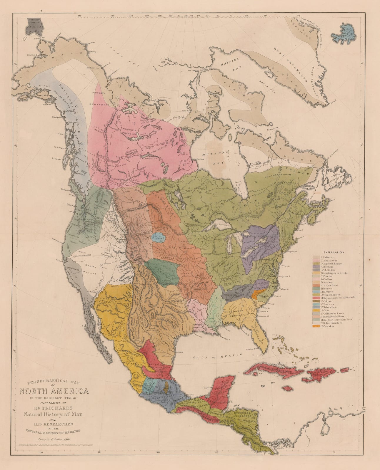
Fascinating ethnographical map of pre-colonial North America showing the distribution of indigenous peoples and cultures.
The map divides the continent into twenty-three regions, each corresponding to the main Indigenous culture that flourished there. These regions are colour-coded and referenced in the legend along the right-hand margin. Uninhabited or unrecorded areas, such as Newfoundland and the Mojave Desert, are left uncoloured.
Topographical detail is minimal, showing only principal mountains, bodies of water, and coastal features. The map extends from the Polar Sea in the north to Panama in the south, also encompassing most of Greenland, Iceland, and the part of the Caribbean.
This map is based on the research of James Cowles Prichard, FRS (1786–1848) a British physician and ethnologist regarded as a foundational figure in early anthropology. Pritchard’s work on which this map is based, “The Natural History of Man” (1843), promoted a then radical belief in monogenism: the belief that all humans share a single common origin, descending from the same ancestral source. Writing in a pre-Darwinian era, Prichard’s research prefigured later evolutionary thought. He was an early member of the Aborigines’ Protection Society and advocated humanitarian treatment of Indigenous peoples.
As is typical of 19th-century ethnographica, Prichard’s map reveals the intellectual limitations and cultural biases of its time. His classifications were influenced by the period’s scientific racism, limited progress in the study of biology, and dependence on secondary sources. For instance, he employs colonial terms such as “Eskimaux” for the Inuit and “Black Foot Indians” for the Niitsitapi. Furthermore, Prichard’s delineations rely on superficial factors like physical appearance and geography, whereas modern anthropology classifies Indigenous peoples through linguistic, cultural, and material evidence—approaches that yield greater accuracy and respect for Indigenous self-identification.
Nevertheless, Prichard’s belief in human unity and his advocacy for Indigenous rights set him apart from many of his contemporaries, making this map a fascinating record of progressive anthropological belief in the earliest days of the discipline.
Original hand colour. [AMER2416]
- X
- Tumblr
Join our mailing list
* denotes required fields
We will process the personal data you have supplied to communicate with you in accordance with our Privacy Policy. You can unsubscribe or change your preferences at any time by clicking the link in our emails.
Contact
The Map House
54 Beauchamp Place,
London SW3 1NY,
United Kingdom
maps@themaphouse.com
+44 (0)20 7589 4325

This website uses cookies
This site uses cookies to help make it more useful to you. Please contact us to find out more about our Cookie Policy.
Join our mailing list
* denotes required fields
We will process the personal data you have supplied to communicate with you in accordance with our Privacy Policy. You can unsubscribe or change your preferences at any time by clicking the link in our emails.

