All Maps
- All
- AFRICA
- ▪ Central Africa
- ▪ East Africa
- ▪ North Africa
- ▪ Southern Africa
- ▪ West Africa
- ▪ Atlantic Islands
- AMERICAS
-
▪ United States (USA)
- USA - East
- USA - Midwest
- USA - Northeast
- USA - Southeast
- USA - West & Southwest
- Alabama
- Alaska
- Arizona
- Arkansas
- California
- Colorado
- Connecticut
- Delaware
- Florida
- Georgia
- Hawaii
- Idaho
- Illinois
- Indiana
- Iowa
- Kansas
- Kentucky
- Louisiana
- Maine
- Maryland
- Massachusetts
- Michigan
- Minnesota
- Mississippi
- Missouri
- Montana
- Nebraska
- Nevada
- New Hampshire
- New Jersey
- New Mexico
- New York
- New York City
- North Carolina
- North Dakota
- Ohio
- Oklahoma
- Oregon
- Pennsylvania
- Rhode Island
- South Carolina
- South Dakota
- Tennessee
- Texas
- Utah
- Vermont
- Virginia
- Washington
- Washington, D.C.
- West Virginia
- Wisconsin
- Wyoming
- ▪ North America
- ▪ South America
- ▪ Caribbean
- ASIA
- ▪ East Asia
- ▪ Southeast Asia
- ▪ India & South Asia
- ▪ Middle East & Turkey
- BRITISH ISLES
- ▪ London
-
▪ England
- English Cities
- Bedfordshire
- Berkshire
- Buckinghamshire
- Cambridgeshire
- Cheshire
- Cornwall
- Cumbria
- Derbyshire
- Devon
- Dorset
- Durham
- Essex
- Gloucestershire
- Hampshire
- Herefordshire
- Hertfordshire
- Huntingdonshire
- Isle of Wight
- Kent
- Lancashire
- Leicestershire
- Lincolnshire
- Middlesex
- Norfolk
- Northamptonshire
- Northumberland
- Nottinghamshire
- Oxfordshire
- Rutland
- Shropshire
- Somerset
- Staffordshire
- Suffolk
- Surrey
- Sussex
- Warwickshire
- Wiltshire
- Worcestershire
- Yorkshire
- Yorkshire East Riding
- Yorkshire North Riding
- Yorkshire West Riding
- ▪ Ireland
- ▪ Scotland
- ▪ Wales
- EUROPE
- ▪ Austria & Switzerland
- ▪ Benelux Region
- ▪ Central & Eastern Europe
- ▪ France & Monaco
- ▪ Germany
- ▪ Greece
- ▪ Italy
- ▪ Mediterranean Sea
- ▪ Spain & Portugal
- ▪ Scandinavia & Baltics
- ▪ Russia, Ukraine & Caucasus
- OCEANIA
- ▪ Australia
- ▪ New Zealand
- ▪ Pacific Ocean & Islands
- ▪ Papua New Guinea
- POLAR
- CELESTIAL
- WORLD
- GLOBES & INSTRUMENTS
- THEMATIC
- COLLABORATIONS
Sebastian Münster
29 x 38 cm
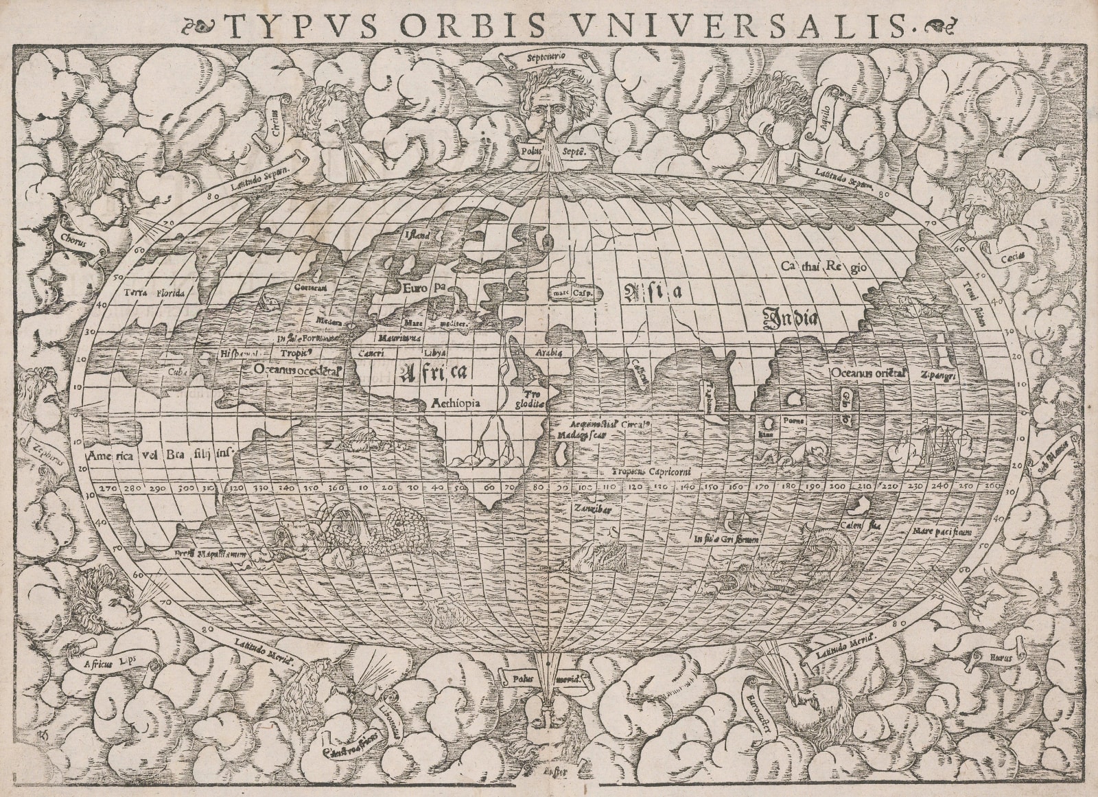
When Munster published his geographical work based on Ptolemy in 1540, he included several “modern” maps, including the world and the four continents to differentiate the advances made in exploration and geography to the current day.
This is the “modern” map of the world on an oval shape. Although geographically quite rudimentary, it still shares a fascinating insight into mid sixteenth century geographical beliefs. It shows a depiction of the New World, a vast northern peninsula connected to northern Europe, serving as possibly part of Greenland entitled the “Terra Nova sive de Bacalhos”, an association with early Portuguese attempts to explore mainland North America. “Bacalhos” is a reference to cod, a major food source for northern European fishermen. This peninsula also bears the name “Islandia” within. The New World also bears a huge bay between “Terra Florida” in the east and “Francisca” in the west, with a panel just above stating that the channel to the east leads to the Moluccas. The Bay is a feature recorded after the exploration of Verrazzano and is sometimes known as the Sea of Verrazzano. It is one of the more famous fallacies on early world maps. Verrazzano sailed along the eastern coast of North America and believed he saw the Pacific Ocean on the other side of the area of Virginia or the Carolinas. It is now believed that what he saw were the Outer Banks.
This is also the first map to use the name “Mare Pacificum” for the Pacific.
The above version of the map was used until 1550, when the plate was re-engraved and several changes were made. In the fine decorations around the map, the names of the winds are now within ribbons. Although the vast northern European peninsula is still present, it has now lost the nomenclature stated above, while Iceland is marked as a separate island. The area in the region of Hudson’s Bay no longer shows the panel stating that this channel leads to the Moluccas although the Sea of Verrazzano is still present.
Finally, the plate is very slightly larger, allowing for a more luxurious cloud border with all of the wind heads now outside the map image. The earlier plate had the two wind heads on the extreme east and west within the map image. In both cases, the wonderful sea monsters are still present albeit changed and the expanded size has allowed for a large ship vignette to be added in the Pacific. A small set of initials “DK” for the engraver (David Kandel), have now been added to the lower left corner.
This example is from the 1572 edition of the “Cosmographia”. [Shirley 92] [WLD4893]
- X
- Tumblr
Join our mailing list
* denotes required fields
We will process the personal data you have supplied to communicate with you in accordance with our Privacy Policy. You can unsubscribe or change your preferences at any time by clicking the link in our emails.
Contact
The Map House
54 Beauchamp Place,
London SW3 1NY,
United Kingdom
maps@themaphouse.com
+44 (0)20 7589 4325

This website uses cookies
This site uses cookies to help make it more useful to you. Please contact us to find out more about our Cookie Policy.
Join our mailing list
* denotes required fields
We will process the personal data you have supplied to communicate with you in accordance with our Privacy Policy. You can unsubscribe or change your preferences at any time by clicking the link in our emails.


