Close

Search Inventory

Maps
Prints
Keyword
Sort
Categories
Year range
-
Purchase options
Width range
Height range
Submit
The Map House company logo
The Map House
Skip to main content
  • Menu
  • Maps
  • Prints
  • Globes
  • New In
  • Resources
  • Events
  • News
  • Contact
Cart
0 items £
Checkout

Item added to cart

View cart & checkout
Continue shopping
Wishlist
0

This item has been saved to your enquiry list

You can either review your list and make an enquiry, or continue to browse and find other artworks.
View list
Continue browsing
Menu
Maps
Our entire inventory of over 10,000 antique and vintage maps is now available to browse by region, date, cartographer, and subject

Brazil

  • All
  • AFRICA
  • ▪ Central Africa
    • Angola
    • Cameroon & Gabon
    • Chad
    • Congo
  • ▪ East Africa
    • Ethiopia, Eritrea & Djibouti
    • Kenya
    • Somalia
    • Sudan
    • Tanzania
    • Uganda, Rwanda & Burundi
  • ▪ North Africa
    • Algeria
    • Egypt
    • Libya
    • Morocco
    • Tunisia
  • ▪ Southern Africa
    • Botswana
    • Madagascar
    • Malawi
    • Mozambique
    • Namibia
    • South Africa
    • Zambia & Zimbabwe
  • ▪ West Africa
    • Cote d'Ivoire
    • Ghana, Benin & Togo
    • Liberia
    • Mali, Niger & Burkina Faso
    • Nigeria
    • Senegal, Gambia & Guinea
    • Sierra Leone
  • ▪ Atlantic Islands
  • AMERICAS
    • Atlantic Ocean
    • Pacific Ocean
  • ▪ United States (USA)
    • USA - East
    • USA - Midwest
    • USA - Northeast
    • USA - Southeast
    • USA - West & Southwest
    • Alabama
    • Alaska
    • Arizona
    • Arkansas
    • California
    • Colorado
    • Connecticut
    • Delaware
    • Florida
    • Georgia
    • Hawaii
    • Idaho
    • Illinois
    • Indiana
    • Iowa
    • Kansas
    • Kentucky
    • Louisiana
    • Maine
    • Maryland
    • Massachusetts
    • Michigan
    • Minnesota
    • Mississippi
    • Missouri
    • Montana
    • Nebraska
    • Nevada
    • New Hampshire
    • New Jersey
    • New Mexico
    • New York
    • New York City
    • North Carolina
    • North Dakota
    • Ohio
    • Oklahoma
    • Oregon
    • Pennsylvania
    • Rhode Island
    • South Carolina
    • South Dakota
    • Tennessee
    • Texas
    • Utah
    • Vermont
    • Virginia
    • Washington
    • Washington, D.C.
    • West Virginia
    • Wisconsin
    • Wyoming
  • ▪ North America
    • Canada
    • Newfoundland & the Maritimes
    • Northern Canada
    • Ontario & Quebec
    • Western Canada
    • Mexico
    • Central America
  • ▪ South America
    • Argentina
    • Bolivia
    • Brazil
    • Chile
    • Colombia
    • Ecuador
    • Falkland Islands
    • Guianas
    • Paraguay
    • Patagonia
    • Peru
    • Uruguay
    • Venezuela
  • ▪ Caribbean
    • Antigua & Barbuda
    • Aruba, Bonaire & Curacao
    • Bahamas
    • Barbados
    • Bermuda
    • Cayman Islands
    • Cuba
    • Dominica
    • Grenada
    • Guadeloupe
    • Haiti & Dominican Rep.
    • Jamaica
    • Martinique
    • Puerto Rico
    • St Kitts & Nevis
    • St Lucia
    • St Vincent & the Grenadines
    • Trinidad & Tobago
    • Turks & Caicos
    • Virgin Islands
  • ASIA
    • Central Asia & Siberia
  • ▪ East Asia
    • China
    • China Regional
    • Beijing
    • Shanghai
    • Hong Kong
    • Tibet
    • Japan
    • Korea
    • Taiwan
  • ▪ Southeast Asia
    • Burma / Myanmar
    • Cambodia, Laos & Vietnam
    • Indonesia & Borneo
    • Malaysia
    • Philippines
    • Singapore
    • Thailand
  • ▪ India & South Asia
    • Afghanistan
    • India
    • India Cities
    • India Regional
    • Indian Ocean & Islands
    • Nepal, Bhutan & Himalayas
    • Pakistan
    • Punjab & Sikh Empire
    • Sri Lanka / Ceylon
  • ▪ Middle East & Turkey
    • Arabia
    • Saudi & Gulf States
    • Iran / Persia
    • Iraq / Mesopotamia
    • Jerusalem
    • Levant / Holy Land
    • Oman & Yemen
    • Turkey
    • Istanbul / Constantinople
  • BRITISH ISLES
    • British Sea Charts
    • British Geological Maps
    • Channel Islands
    • Isle of Man
  • ▪ London
    • Underground & Transport
    • Central London & The City
    • East London
    • North & Northwest London
    • Southeast London
    • West & Southwest London
  • ▪ England
    • English Cities
    • Bedfordshire
    • Berkshire
    • Buckinghamshire
    • Cambridgeshire
    • Cheshire
    • Cornwall
    • Cumbria
    • Derbyshire
    • Devon
    • Dorset
    • Durham
    • Essex
    • Gloucestershire
    • Hampshire
    • Herefordshire
    • Hertfordshire
    • Huntingdonshire
    • Isle of Wight
    • Kent
    • Lancashire
    • Leicestershire
    • Lincolnshire
    • Middlesex
    • Norfolk
    • Northamptonshire
    • Northumberland
    • Nottinghamshire
    • Oxfordshire
    • Rutland
    • Shropshire
    • Somerset
    • Staffordshire
    • Suffolk
    • Surrey
    • Sussex
    • Warwickshire
    • Wiltshire
    • Worcestershire
    • Yorkshire
    • Yorkshire East Riding
    • Yorkshire North Riding
    • Yorkshire West Riding
  • ▪ Ireland
    • Dublin
    • N. Ireland / Ulster
    • Rep. of Ireland Counties
    • Rep. of Ireland Cities
  • ▪ Scotland
    • Edinburgh
    • Glasgow
    • Scotland Regional
    • Shetland, Orkney & Hebrides
  • ▪ Wales
    • North Wales
    • South Wales
    • Anglesey
    • Breconshire
    • Cardiganshire
    • Carmarthenshire
    • Caernarfonshire
    • Denbighshire
    • Flintshire
    • Cardiff & Glamorgan
    • Merionethshire
    • Monmouthshire
    • Montgomeryshire
    • Pembrokeshire
    • Radnorshire
  • EUROPE
  • ▪ Austria & Switzerland
    • Austria
    • Switzerland
    • Switzerland - Cities
    • The Alps
  • ▪ Benelux Region
    • Belgium
    • Luxembourg
    • Netherlands
    • Netherlands - Cities
  • ▪ Central & Eastern Europe
    • Balkans
    • Belarus
    • Bulgaria
    • Croatia
    • Czech Rep. & Slovakia
    • Hungary
    • Poland
    • Romania & Transylvania
  • ▪ France & Monaco
    • France
    • Paris
    • French Wine Maps
    • French Cities
    • French Regions
    • Provence & Cote d'Azur
    • Monaco
  • ▪ Germany
    • German Cities
    • German Regions
    • Prussia
  • ▪ Greece
    • Greek Islands
  • ▪ Italy
    • Italian Cities
    • Northern Italy
    • Tuscany & Central Italy
    • Southern Italy & Sicily
  • ▪ Mediterranean Sea
    • Corsica
    • Cyprus
    • Elba
    • Malta
    • Sardinia
  • ▪ Spain & Portugal
    • Spain
    • Spain - Regional
    • Spain - Cities
    • Balearic Islands
    • Gibraltar
    • Portugal
  • ▪ Scandinavia & Baltics
    • Baltic States
    • Denmark
    • Finland
    • Iceland & Greenland
    • Norway
    • Sweden
  • ▪ Russia, Ukraine & Caucasus
    • Russia
    • Asiatic Russia / Siberia
    • European Russia
    • Russian Cities
    • Caucasus & Caspian Sea
    • Ukraine, Black Sea & Crimea
  • OCEANIA
  • ▪ Australia
    • Sydney
    • New South Wales
    • Northern Territory
    • Queensland
    • South Australia
    • Tasmania
    • Victoria
    • Western Australia
  • ▪ New Zealand
  • ▪ Pacific Ocean & Islands
  • ▪ Papua New Guinea
  • POLAR
    • Antarctica
    • The Arctic
    • Polar World Maps
  • CELESTIAL
    • Celestial Maps
    • The Moon & Planets
  • WORLD
    • World Maps
    • Thematic World Maps
    • World & Continent Sets
    • Title Pages
    • Portolan Charts
  • GLOBES & INSTRUMENTS
    • Terrestrial Globes
    • Celestial & Moon Globes
    • Pairs of Globes
    • Scientific Instruments
  • THEMATIC
    • Island of California
    • Commodities & Trade
    • Noted Explorers
    • Geological
    • Historical
    • Infographics
    • Oceanography
    • Pictorial
    • Posters
    • Sea Charts
    • Space Age
    • Republic of Texas
    • Transport
    • War Maps
  • COLLABORATIONS
    • Adam Dant
    • Kristjana S. Williams
    • Justine Smith
Open a larger version of the following image in a popup: Jan Blaeu, Blaeu's Spectacular Maps of Brazil [set of 6], 1662
Open a larger version of the following image in a popup: Jan Blaeu, Blaeu's Spectacular Maps of Brazil [set of 6], 1662 Brasilia
Open a larger version of the following image in a popup: Jan Blaeu, Blaeu's Spectacular Maps of Brazil [set of 6], 1662 Præfecturæ De Paraiba, et Rio Grande.
Open a larger version of the following image in a popup: Jan Blaeu, Blaeu's Spectacular Maps of Brazil [set of 6], 1662 Præfectura De Cirîiî, vek Seregippe Delrey cum Itâpuáma.
Open a larger version of the following image in a popup: Jan Blaeu, Blaeu's Spectacular Maps of Brazil [set of 6], 1662 Sinus Omnium Sanctoru
Open a larger version of the following image in a popup: Jan Blaeu, Blaeu's Spectacular Maps of Brazil [set of 6], 1662 Præfecturæ Paranambuæ pars Meridionalis.
Open a larger version of the following image in a popup: Jan Blaeu, Blaeu's Spectacular Maps of Brazil [set of 6], 1662 Præfecturæ Paranambuæ pars Borealis, una cum Præfectura Itâmaracâ.

Jan Blaeu

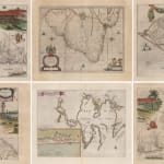
Blaeu's Spectacular Maps of Brazil [set of 6], 1662
16 ½ x 21 ½ in each
42 x 54 cm each
SAM3060
Save
Remove
Enquire
%3Cdiv%20class%3D%22artist%22%3EJan%20Blaeu%3C/div%3E%3Cdiv%20class%3D%22title_and_year%22%3E%3Cspan%20class%3D%22title_and_year_title%22%3EBlaeu%27s%20Spectacular%20Maps%20of%20Brazil%20%5Bset%20of%206%5D%3C/span%3E%2C%20%3Cspan%20class%3D%22title_and_year_year%22%3E1662%3C/span%3E%3C/div%3E%3Cdiv%20class%3D%22dimensions%22%3E16%20%C2%BD%20x%2021%20%C2%BD%20in%20each%3Cbr/%3E%0A42%20x%2054%20cm%20each%3C/div%3E

Further images

  • (View a larger image of thumbnail 1 ) Thumbnail of additional image
  • (View a larger image of thumbnail 2 ) Thumbnail of additional image
  • (View a larger image of thumbnail 3 ) Thumbnail of additional image
  • (View a larger image of thumbnail 4 ) Thumbnail of additional image
  • (View a larger image of thumbnail 5 ) Thumbnail of additional image
  • (View a larger image of thumbnail 6 ) Thumbnail of additional image
  • (View a larger image of thumbnail 7 ) Thumbnail of additional image
View on a Wall
These maps impressively detail the Dutch possessions in Brazil. Whilst these colonies were short lived – only existing from 1630 until 1661 – they are powerful in promoting the colony...
View full details

These maps impressively detail the Dutch possessions in Brazil. Whilst these colonies were short lived – only existing from 1630 until 1661 – they are powerful in promoting the colony and the Dutch’s magnificent mapping skills, ultimately making the colony’s legacy last.


The Dutch gained control of a large area of North-Eastern Brazil from the Portuguese in 1630 and the Dutch East India Company soon built their headquarters in Recife. Governed by Johan Maurits, scientists and artists were invited to visit and settle here with the intention of promoting migration and trade to their new South American colony.


The Portuguese, obviously bitter with their loss, fought for their former territory. In 1649, during the Second Battle of Guararapes, in a conflict known as the Pernambucana Insurrection at Jaboatão dos Guararapes between the Dutch and the Portuguese – ending in a decisive Portuguese victory.


Eventually in 1654, the Dutch surrendered their control over the area and returned it back to the Portuguese. However, after the First Anglo-Dutch war only four months later in May 1654; the Dutch Republic demanded back the control over New Holland (the name for the Dutch possessions in Brazil).


Under threat from occupation in Lisbon and re-occupation in Brazil, the Portuguese who were already involved in a conflict against Spain gave in to the Dutch demand. Dutch leader Johan de Witt was however more interested in the trading prospects than the territorial claims and arranged for the North Eastern Brazilian colony was sold back to Portuguese through the Treaty of the Hague (1661).


The groundwork for these maps was an astonishing nine-sheet copper-engraved map by geographer and natural historian, Georg Marcgraf, and included illustrations that have been attributed to artist, Frans Post. Marcgraf was a German astronomer, geographer and naturalist and in 1637 he was appointed astronomer for a company due to set sail for the Dutch colony. He was accompanied by William Piso, a physician who had been recently appointed to govern the Dutch possessions in Brazil. Marcgraf and Piso arrived in 1638 and undertook the very first expedition and study into the natural history and geography of the area – researching everything from zoology and botany to astronomy. They co-authored “Historia Naturalis Brasiliae”, an eight volume work published in 1648 for which both of them are best remembered.


This set of six maps were published just one year after the territory was formally returned to the Portuguese. They were published in Amsterdam by Jan Blaeu, who were leaders during a time known as The Dutch Golden Age of Cartography. 


The Dutch publishing house was established in 1596 by Willem Janszoon Blaeu, who had studied as a young man under the great astronomer, Tycho Brahe. They originally produced globes and scientific instruments. However, the firm soon expanded into map making and publishing, and eventually became one of the most important and prolific map producers in Amsterdam and recognised throughout the World. In 1623 they published the “Het Licht der Zeevaerdt” an atlas of sea-charts. In 1629 Willem and his son Joan purchased 37 engraved plates from the widow of their rival Hondius and the following year they produced their first land atlas, the “Atlantis Appendix”. In 1635 this was expanded into the “Atlas Novus” a major world atlas in six volumes and many languages, from 1635-59.


After the death of his father, Joan Blaeu embarked on one of the most ambitious publishing undertakings of the 17th Century, the printing of the “Atlas Maior”. This magnificent work was to contain nearly six hundred maps and, depending on the edition, was to vary from nine to twelve volumes. The exquisite engraving, often allied with lovely hand-colouring, make maps from the “Novus” and “Maior” atlases some of the finest ever printed.


The “Atlas Maior” was to be the crowning glory of the Blaeu firm. Tragically in 1672 a disastrous fire swept through the Blaeu printing house destroying much of the stock and most of the copper engraving plates. The following year Joan died and the surviving plates were dispersed. Reflecting their contemporary reputations Willem and Joan were in turn both appointed Hydrographer to the Dutch East India Company and their atlases were frequently presented to foreign sovereigns and potentates by the Dutch government.


Original hand colour. Set of six maps framed.

[SAM3060]
Close full details
Share
  • Facebook
  • X
  • Pinterest
  • Tumblr
  • Email
Previous
|
Next
1 
of  41

Join our mailing list

Submit

* denotes required fields

We will process the personal data you have supplied to communicate with you in accordance with our Privacy Policy. You can unsubscribe or change your preferences at any time by clicking the link in our emails.

Contact

The Map House

54 Beauchamp Place,
London SW3 1NY,

United Kingdom


maps@themaphouse.com
+44 (0)20 7589 4325

Shipping

Privacy

Contact

Framing

We Buy Maps

Instagram, opens in a new tab.
Twitter, opens in a new tab.
Facebook, opens in a new tab.
Youtube, opens in a new tab.
Privacy Policy
Manage cookies
Copyright © 2025 The Map House
Site by Artlogic

This website uses cookies
This site uses cookies to help make it more useful to you. Please contact us to find out more about our Cookie Policy.

Manage cookies
Accept

Cookie preferences

Check the boxes for the cookie categories you allow our site to use

Cookie options
Required for the website to function and cannot be disabled.
Improve your experience on the website by storing choices you make about how it should function.
Allow us to collect anonymous usage data in order to improve the experience on our website.
Allow us to identify our visitors so that we can offer personalised, targeted marketing.
Save preferences
Close

Join our mailing list

Submit

* denotes required fields

We will process the personal data you have supplied to communicate with you in accordance with our Privacy Policy. You can unsubscribe or change your preferences at any time by clicking the link in our emails.