Cornwall
- All
- AFRICA
- ▪ Central Africa
- ▪ East Africa
- ▪ North Africa
- ▪ Southern Africa
- ▪ West Africa
- ▪ Atlantic Islands
- AMERICAS
-
▪ United States (USA)
- USA - East
- USA - Midwest
- USA - Northeast
- USA - Southeast
- USA - West & Southwest
- Alabama
- Alaska
- Arizona
- Arkansas
- California
- Colorado
- Connecticut
- Delaware
- Florida
- Georgia
- Hawaii
- Idaho
- Illinois
- Indiana
- Iowa
- Kansas
- Kentucky
- Louisiana
- Maine
- Maryland
- Massachusetts
- Michigan
- Minnesota
- Mississippi
- Missouri
- Montana
- Nebraska
- Nevada
- New Hampshire
- New Jersey
- New Mexico
- New York
- New York City
- North Carolina
- North Dakota
- Ohio
- Oklahoma
- Oregon
- Pennsylvania
- Rhode Island
- South Carolina
- South Dakota
- Tennessee
- Texas
- Utah
- Vermont
- Virginia
- Washington
- Washington, D.C.
- West Virginia
- Wisconsin
- Wyoming
- ▪ North America
- ▪ South America
- ▪ Caribbean
- ASIA
- ▪ East Asia
- ▪ Southeast Asia
- ▪ India & South Asia
- ▪ Middle East & Turkey
- BRITISH ISLES
- ▪ London
-
▪ England
- English Cities
- Bedfordshire
- Berkshire
- Buckinghamshire
- Cambridgeshire
- Cheshire
- Cornwall
- Cumbria
- Derbyshire
- Devon
- Dorset
- Durham
- Essex
- Gloucestershire
- Hampshire
- Herefordshire
- Hertfordshire
- Huntingdonshire
- Isle of Wight
- Kent
- Lancashire
- Leicestershire
- Lincolnshire
- Middlesex
- Norfolk
- Northamptonshire
- Northumberland
- Nottinghamshire
- Oxfordshire
- Rutland
- Shropshire
- Somerset
- Staffordshire
- Suffolk
- Surrey
- Sussex
- Warwickshire
- Wiltshire
- Worcestershire
- Yorkshire
- Yorkshire East Riding
- Yorkshire North Riding
- Yorkshire West Riding
- ▪ Ireland
- ▪ Scotland
- ▪ Wales
- EUROPE
- ▪ Austria & Switzerland
- ▪ Benelux Region
- ▪ Central & Eastern Europe
- ▪ France & Monaco
- ▪ Germany
- ▪ Greece
- ▪ Italy
- ▪ Mediterranean Sea
- ▪ Spain & Portugal
- ▪ Scandinavia & Baltics
- ▪ Russia, Ukraine & Caucasus
- OCEANIA
- ▪ Australia
- ▪ New Zealand
- ▪ Pacific Ocean & Islands
- ▪ Papua New Guinea
- POLAR
- CELESTIAL
- WORLD
- GLOBES & INSTRUMENTS
- THEMATIC
- COLLABORATIONS
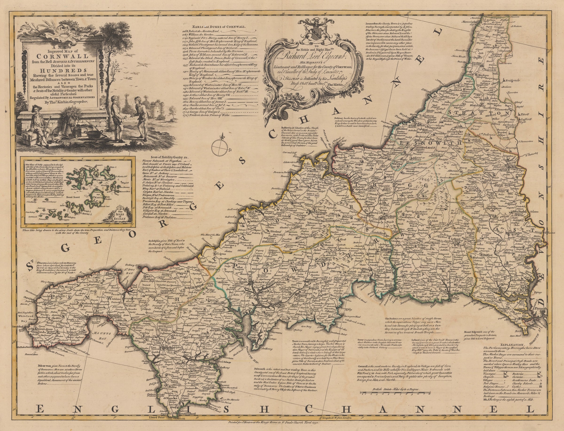
Emanuel Bowen
53.3 x 69 cm
Emanuel Bowen’s “Large English Atlas” is the first large scale county atlas since the mid 17th century. The maps were sourced either from surveys commissioned by Bowen or from local up to date maps purchased by Bowen and adapted to his style. Due to these first hand sources, it was the most geographically current atlas until 1787, when John Cary published his own county atlas.
As with most of Bowen’s projects, the financing for this work was dependent on future sales, subscriptions and credit. Loose examples of the maps became commercially available as soon as they were finished, beginning with the map of Sussex in 1749. Several important publishers are listed on the lower margin, probably the main suppliers of the loose maps. The early examples involve John Tinney, the Bowles Family and Robert Sayer. As the project evolved to its later stages, some publishers such as John Tinney were removed while others, such as Robert Wilkinson were added. The first issues of the atlas are recorded c.1760, suggesting that it took approximately eleven years for all the counties to be prepared although there are small variations in the contents of the atlases. The last examples are recorded as late as c1794 although the name has been changed to The English Atlas. There were also further versions of the work entitled “The Royal English Atlas” and the “Atlas Anglicanus “ which contained essentially the same maps, in the same style but in different sizes.
Stylistically, the maps are very different from their predecessors and reflected the dawning of the Age of Reason. The engraving is sophisticated and of high quality. The maps are of a uniform style, with several panels of text on each one, describing geographical features of the county, places of note and the history of important aristocratic families. Both Bowen himself and his apprentice and later partner, Thomas Kitchin are listed as the main authors of each county either together or individually.
For the modern collector, these represent one of the high points in the history of English county maps.
This example of the map bears its original issue date of 1750 and lists John Hinton as the main publisher. Hinton was another of the early publishers supporting this project but pulled out quite early, probably due to lack of funds. He is best known for his important gazetteer, "The Universal Magazine of Knowledge and Pleasure" which often used maps by Bowen within its contents. Original colour. [CORN584]
- X
- Tumblr
Join our mailing list
* denotes required fields
We will process the personal data you have supplied to communicate with you in accordance with our Privacy Policy. You can unsubscribe or change your preferences at any time by clicking the link in our emails.
Contact
The Map House
54 Beauchamp Place,
London SW3 1NY,
United Kingdom
maps@themaphouse.com
+44 (0)20 7589 4325
![]()
This website uses cookies
This site uses cookies to help make it more useful to you. Please contact us to find out more about our Cookie Policy.
Join our mailing list
* denotes required fields
We will process the personal data you have supplied to communicate with you in accordance with our Privacy Policy. You can unsubscribe or change your preferences at any time by clicking the link in our emails.