- All
- AFRICA
- ▪ Central Africa
- ▪ East Africa
- ▪ North Africa
- ▪ Southern Africa
- ▪ West Africa
- ▪ Atlantic Islands
- AMERICAS
-
▪ United States (USA)
- USA - East
- USA - Midwest
- USA - Northeast
- USA - Southeast
- USA - West & Southwest
- Alabama
- Alaska
- Arizona
- Arkansas
- California
- Colorado
- Connecticut
- Delaware
- Florida
- Georgia
- Hawaii
- Idaho
- Illinois
- Indiana
- Iowa
- Kansas
- Kentucky
- Louisiana
- Maine
- Maryland
- Massachusetts
- Michigan
- Minnesota
- Mississippi
- Missouri
- Montana
- Nebraska
- Nevada
- New Hampshire
- New Jersey
- New Mexico
- New York
- New York City
- North Carolina
- North Dakota
- Ohio
- Oklahoma
- Oregon
- Pennsylvania
- Rhode Island
- South Carolina
- South Dakota
- Tennessee
- Texas
- Utah
- Vermont
- Virginia
- Washington
- Washington, D.C.
- West Virginia
- Wisconsin
- Wyoming
- ▪ North America
- ▪ South America
- ▪ Caribbean
- ASIA
- ▪ East Asia
- ▪ Southeast Asia
- ▪ India & South Asia
- ▪ Middle East & Turkey
- BRITISH ISLES
- ▪ London
-
▪ England
- English Cities
- Bedfordshire
- Berkshire
- Buckinghamshire
- Cambridgeshire
- Cheshire
- Cornwall
- Cumbria
- Derbyshire
- Devon
- Dorset
- Durham
- Essex
- Gloucestershire
- Hampshire
- Herefordshire
- Hertfordshire
- Huntingdonshire
- Isle of Wight
- Kent
- Lancashire
- Leicestershire
- Lincolnshire
- Middlesex
- Norfolk
- Northamptonshire
- Northumberland
- Nottinghamshire
- Oxfordshire
- Rutland
- Shropshire
- Somerset
- Staffordshire
- Suffolk
- Surrey
- Sussex
- Warwickshire
- Wiltshire
- Worcestershire
- Yorkshire
- Yorkshire East Riding
- Yorkshire North Riding
- Yorkshire West Riding
- ▪ Ireland
- ▪ Scotland
- ▪ Wales
- EUROPE
- ▪ Austria & Switzerland
- ▪ Benelux Region
- ▪ Central & Eastern Europe
- ▪ France & Monaco
- ▪ Germany
- ▪ Greece
- ▪ Italy
- ▪ Mediterranean Sea
- ▪ Spain & Portugal
- ▪ Scandinavia & Baltics
- ▪ Russia, Ukraine & Caucasus
- OCEANIA
- ▪ Australia
- ▪ New Zealand
- ▪ Pacific Ocean & Islands
- ▪ Papua New Guinea
- POLAR
- CELESTIAL
- WORLD
- GLOBES & INSTRUMENTS
- THEMATIC
- COLLABORATIONS
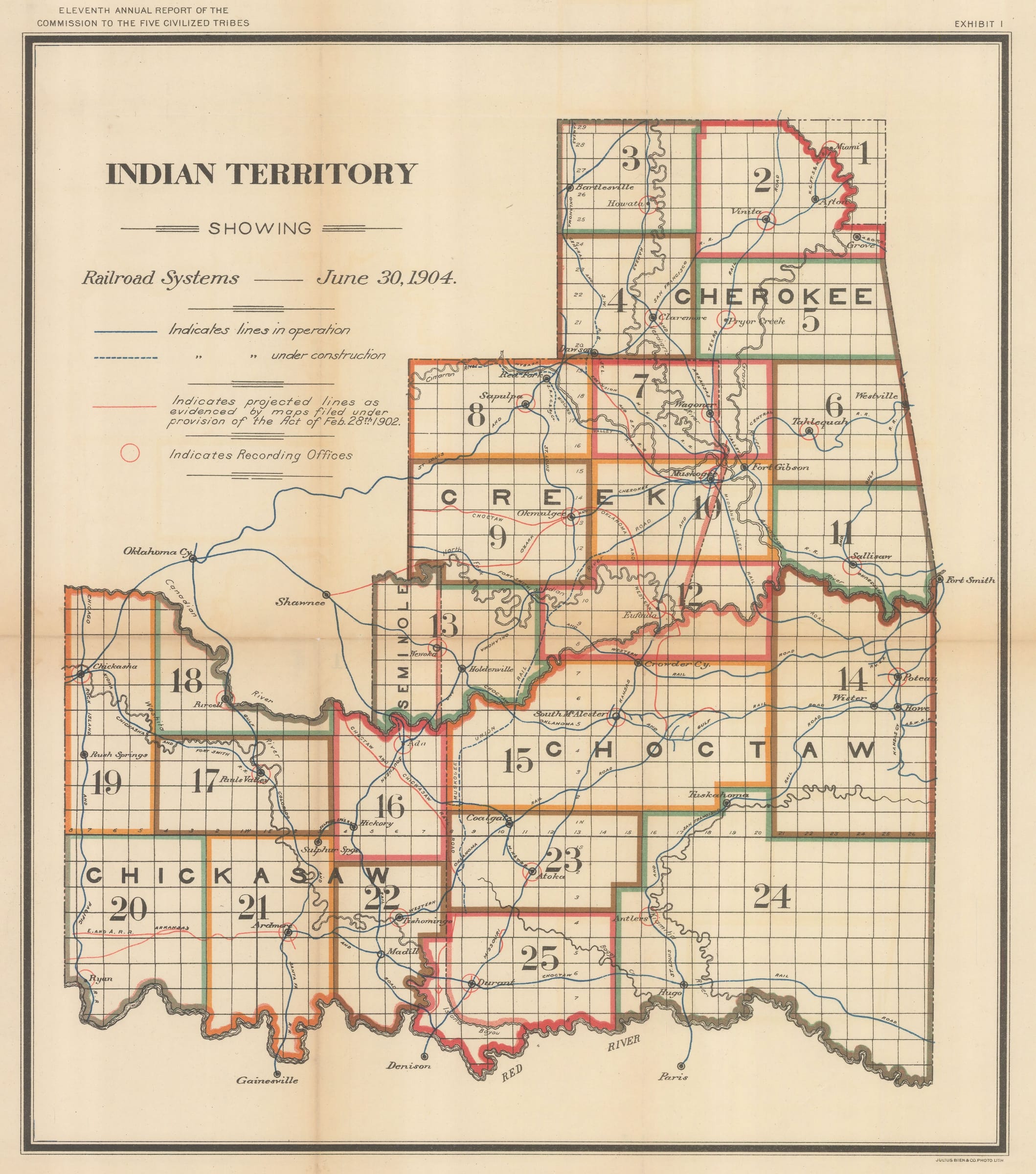
Dawes Commission
45 x 39 cm
The Dawes Commission was created in 1893 to negotiate with the five "civilized tribes", the Creek, the Seminoles, the Choctaw, the Cherokee, and the Chickasaw, all of whom had been forcibly relocated to Oklahoma during the Trail of Tears in the 1830s. The Commission's goal was to convince the members of these nations to abandon their communal tribal land rights, to divide the lands into individual parcels, and to distribute the newly-divided lots to individual members of the tribe. By this method, the US government hoped to compile citizenship rolls for each of the five nations and facilitate European-American settlement of former Native American land.
The grid which overlays this map shows how the U.S. government had begun to divide the Native American lands into square parcels after 11 years of registration work by the Dawes Commission.
The results of the Dawes Commission were devastating to many member of the Five Nations, some of whom are still fighting court battles to this day to reclaim nationhood which was unfairly stripped away from them. African Americans with some Native American ancestry were particularly affected by the Dawes Commission which used an individual's outward appearance and "blood heritage" to determine whether they could belong to a tribal nation. Former slaves belonging to Native Americans who were freed after the Civil War were legally eligible to become members of the tribes of their former owners, but many of these individuals were excluded from membership by the tribes and included on separate "Freedmen Rolls' instead, thus forfeiting any claim to tribal land.
The Five Nations also lost enormous swathes of their former land grants as the Dawes Commission was authorized to auction off any "surplus land" after all of the members of a tribe had been allocated a plot. This, of course, created a perverse incentive for the Commission to undercount or reject members of the tribes so that more land could be sold to European-American settlers. Individual members of the tribes were also allowed to sell their parcels if they wished, something which had not previously been allowed when land was held communally by the whole Tribal Nation.
Photo-lithographed by Julius Bien & Co. and printed by the Office of Government Printing on behalf of the Department of the Interior. Printed colour. (SL) [USA9083]
- X
- Tumblr
Join our mailing list
* denotes required fields
We will process the personal data you have supplied to communicate with you in accordance with our Privacy Policy. You can unsubscribe or change your preferences at any time by clicking the link in our emails.
Contact
The Map House
54 Beauchamp Place,
London SW3 1NY,
United Kingdom
maps@themaphouse.com
+44 (0)20 7589 4325
![]()
This website uses cookies
This site uses cookies to help make it more useful to you. Please contact us to find out more about our Cookie Policy.
Join our mailing list
* denotes required fields
We will process the personal data you have supplied to communicate with you in accordance with our Privacy Policy. You can unsubscribe or change your preferences at any time by clicking the link in our emails.