- All
- AFRICA
- ▪ Central Africa
- ▪ East Africa
- ▪ North Africa
- ▪ Southern Africa
- ▪ West Africa
- ▪ Atlantic Islands
- AMERICAS
-
▪ United States (USA)
- USA - East
- USA - Midwest
- USA - Northeast
- USA - Southeast
- USA - West & Southwest
- Alabama
- Alaska
- Arizona
- Arkansas
- California
- Colorado
- Connecticut
- Delaware
- Florida
- Georgia
- Hawaii
- Idaho
- Illinois
- Indiana
- Iowa
- Kansas
- Kentucky
- Louisiana
- Maine
- Maryland
- Massachusetts
- Michigan
- Minnesota
- Mississippi
- Missouri
- Montana
- Nebraska
- Nevada
- New Hampshire
- New Jersey
- New Mexico
- New York
- New York City
- North Carolina
- North Dakota
- Ohio
- Oklahoma
- Oregon
- Pennsylvania
- Rhode Island
- South Carolina
- South Dakota
- Tennessee
- Texas
- Utah
- Vermont
- Virginia
- Washington
- Washington, D.C.
- West Virginia
- Wisconsin
- Wyoming
- ▪ North America
- ▪ South America
- ▪ Caribbean
- ASIA
- ▪ East Asia
- ▪ Southeast Asia
- ▪ India & South Asia
- ▪ Middle East & Turkey
- BRITISH ISLES
- ▪ London
-
▪ England
- English Cities
- Bedfordshire
- Berkshire
- Buckinghamshire
- Cambridgeshire
- Cheshire
- Cornwall
- Cumbria
- Derbyshire
- Devon
- Dorset
- Durham
- Essex
- Gloucestershire
- Hampshire
- Herefordshire
- Hertfordshire
- Huntingdonshire
- Isle of Wight
- Kent
- Lancashire
- Leicestershire
- Lincolnshire
- Middlesex
- Norfolk
- Northamptonshire
- Northumberland
- Nottinghamshire
- Oxfordshire
- Rutland
- Shropshire
- Somerset
- Staffordshire
- Suffolk
- Surrey
- Sussex
- Warwickshire
- Wiltshire
- Worcestershire
- Yorkshire
- Yorkshire East Riding
- Yorkshire North Riding
- Yorkshire West Riding
- ▪ Ireland
- ▪ Scotland
- ▪ Wales
- EUROPE
- ▪ Austria & Switzerland
- ▪ Benelux Region
- ▪ Central & Eastern Europe
- ▪ France & Monaco
- ▪ Germany
- ▪ Greece
- ▪ Italy
- ▪ Mediterranean Sea
- ▪ Spain & Portugal
- ▪ Scandinavia & Baltics
- ▪ Russia, Ukraine & Caucasus
- OCEANIA
- ▪ Australia
- ▪ New Zealand
- ▪ Pacific Ocean & Islands
- ▪ Papua New Guinea
- POLAR
- CELESTIAL
- WORLD
- GLOBES & INSTRUMENTS
- THEMATIC
- COLLABORATIONS
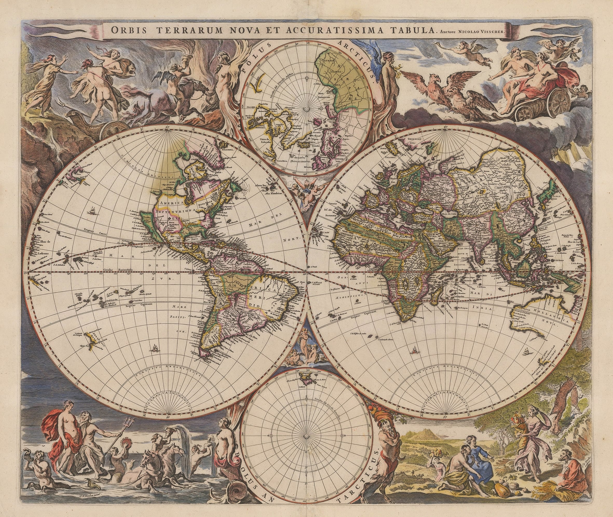
C. & N. Visscher
47 x 55 cm
Their entry into the field of cartography was masterminded by Claes Janszoon Visscher II who sometimes Latinised his name to Nicholas Piscator. Upon the former's death in 1652, his son, Nicholas Visscher I stepped seamlessly into his father's place and continued to produce many important and highly decorative maps of all parts of the world, including this fine example of a double hemisphere map of the earth.
Geographically the map is mostly based on Joan Blaeu's extraordinary double hemisphere wall map of the world published in 1648. It is one of the earliest maps to show the discoveries of Abel Tasman's voyages to Australia and New Zealand in 1642 and 1644. Africa is shown with its characteristic elongated western coast and the Far East is based Willem Blaeu's map of the region which was sourced from the charts of the Dutch East India Company, with whom the Blaeu family were strongly connected. All of these features are reproduced on this map by Visscher. Curiously, where Visscher does differ from this source is in the portrayal of the west coast of America and California. Both maps show California as a separate island but unlike Blaeu, Visscher portrays the island with a flat top as first drawn by Henry Briggs in 1625. He also draws a faint coastline towards Hudson Bay. Visscher was suggesting that the landmass narrowed dramatically between the Atlantic and Pacific Oceans further north, with a possible channel existing next to the mythical land of Anian north of California. All of this is done very tentatively and without a cartographic commitment but with extremely strong hints and differs completely from Blaeu's wall map which leaves this area as unknown.
As was traditional for the time, the map is very ornate with two circular insets of the Poles in the upper and lower centre and four allegorical scenes, one in each corner; in this case they symbolise the elements. These scenes can be credited to the highly influential and important Dutch painter Nicolaes Pieterszoon Berchem, whose signature is present on the lower left on the scene symbolising water.
This map was highly influential, acting as a source for many following map makers. Ironically, one of these may have been Joan Blaeu himself, who issued his own double hemisphere in 1658, in preparation of his Atlas Major of 1662, although there is some debate as to when that map was engraved. The latter's map bears some similarity to Visscher's map, especially in the portrayal of California and the west.
[Shirley 406] [WLD4313]
- X
- Tumblr
Join our mailing list
* denotes required fields
We will process the personal data you have supplied to communicate with you in accordance with our Privacy Policy. You can unsubscribe or change your preferences at any time by clicking the link in our emails.
Contact
The Map House
54 Beauchamp Place,
London SW3 1NY,
United Kingdom
maps@themaphouse.com
+44 (0)20 7589 4325
![]()
This website uses cookies
This site uses cookies to help make it more useful to you. Please contact us to find out more about our Cookie Policy.
Join our mailing list
* denotes required fields
We will process the personal data you have supplied to communicate with you in accordance with our Privacy Policy. You can unsubscribe or change your preferences at any time by clicking the link in our emails.