- All
- AFRICA
- ▪ Central Africa
- ▪ East Africa
- ▪ North Africa
- ▪ Southern Africa
- ▪ West Africa
- ▪ Atlantic Islands
- AMERICAS
-
▪ United States
- USA - East
- USA - Midwest
- USA - Northeast
- USA - Southeast
- USA - West & Southwest
- Alabama
- Alaska
- Arizona
- Arkansas
- California
- Colorado
- Connecticut
- Delaware
- Florida
- Georgia
- Hawaii
- Idaho
- Illinois
- Indiana
- Iowa
- Kansas
- Kentucky
- Louisiana
- Maine
- Maryland
- Massachusetts
- Michigan
- Minnesota
- Mississippi
- Missouri
- Montana
- Nebraska
- Nevada
- New Hampshire
- New Jersey
- New Mexico
- New York
- New York City
- North Carolina
- North Dakota
- Ohio
- Oklahoma
- Oregon
- Pennsylvania
- Rhode Island
- South Carolina
- South Dakota
- Tennessee
- Texas
- Utah
- Vermont
- Virginia
- Washington
- Washington, D.C.
- West Virginia
- Wisconsin
- Wyoming
- ▪ North America
- ▪ South America
- ▪ Caribbean
- ASIA
- ▪ East Asia
- ▪ Southeast Asia
- ▪ India & South Asia
- ▪ Middle East & Turkey
- BRITISH ISLES
- ▪ London
-
▪ England
- English Cities
- Bedfordshire
- Berkshire
- Buckinghamshire
- Cambridgeshire
- Cheshire
- Cornwall
- Cumbria
- Derbyshire
- Devon
- Dorset
- Durham
- Essex
- Gloucestershire
- Hampshire
- Herefordshire
- Hertfordshire
- Huntingdonshire
- Isle of Wight
- Kent
- Lancashire
- Leicestershire
- Lincolnshire
- Middlesex
- Norfolk
- Northamptonshire
- Northumberland
- Nottinghamshire
- Oxfordshire
- Rutland
- Shropshire
- Somerset
- Staffordshire
- Suffolk
- Surrey
- Sussex
- Warwickshire
- Wiltshire
- Worcestershire
- Yorkshire
- Yorkshire East Riding
- Yorkshire North Riding
- Yorkshire West Riding
- ▪ Ireland
- ▪ Scotland
- ▪ Wales
- EUROPE
- ▪ Austria & Switzerland
- ▪ Benelux Region
- ▪ Central & Eastern Europe
- ▪ France & Monaco
- ▪ Germany
- ▪ Greece
- ▪ Italy
- ▪ Mediterranean Sea
- ▪ Spain & Portugal
- ▪ Scandinavia & Baltics
- ▪ Russia, Ukraine & Caucasus
- OCEANIA
- ▪ Australia
- ▪ New Zealand
- ▪ Pacific Ocean & Islands
- ▪ Papua New Guinea
- POLAR
- CELESTIAL
- WORLD
- GLOBES & INSTRUMENTS
- THEMATIC
- COLLABORATIONS
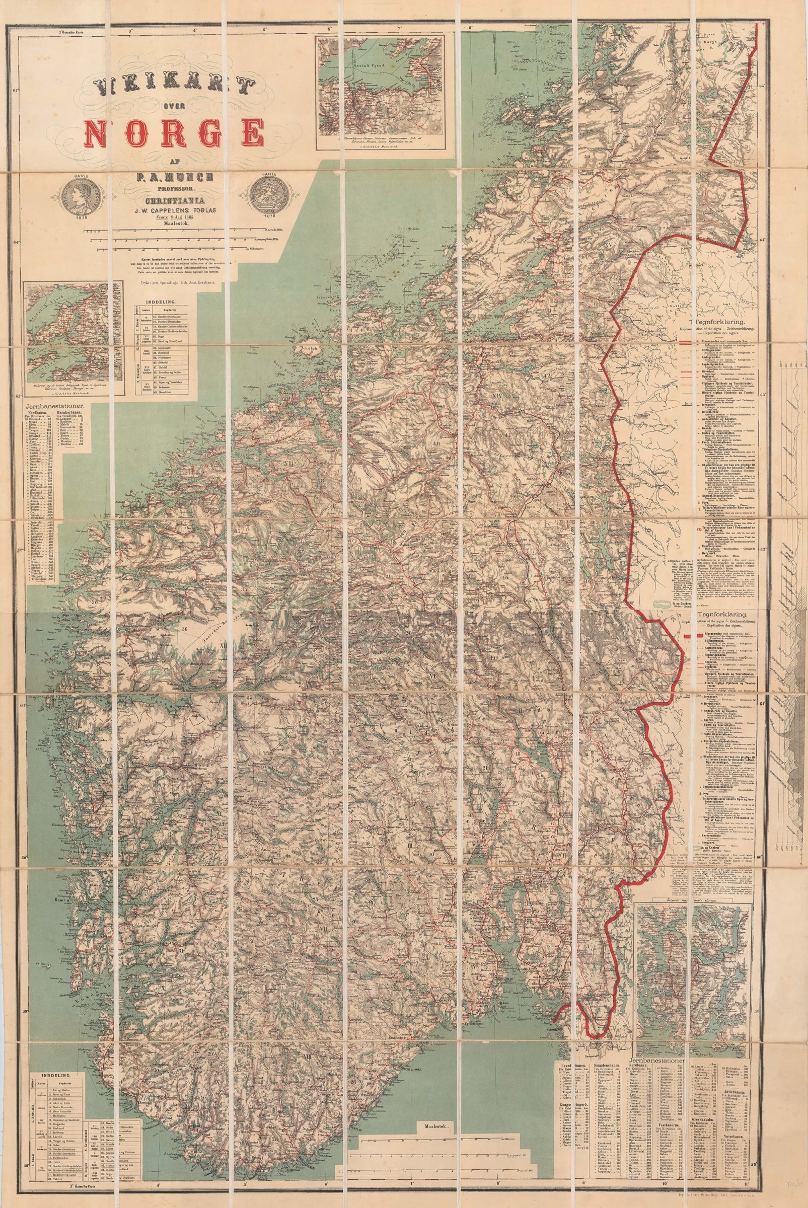
P. A. Munch
Southern Norway, 1885
47 ½ x 32 in
121 x 81 cm
121 x 81 cm
SCAN2504
£ 675.00
P. A. Munch, Southern Norway, 1885
Sold
%3Cdiv%20class%3D%22artist%22%3EP.%20A.%20Munch%3C/div%3E%3Cdiv%20class%3D%22title_and_year%22%3E%3Cspan%20class%3D%22title_and_year_title%22%3ESouthern%20Norway%3C/span%3E%2C%20%3Cspan%20class%3D%22title_and_year_year%22%3E1885%3C/span%3E%3C/div%3E%3Cdiv%20class%3D%22dimensions%22%3E47%20%C2%BD%20x%2032%20in%3Cbr/%3E%0A121%20x%2081%20cm%3C/div%3E
Veikart over Norge Separately issued folding map of Norway showing the railway lines and with three insets of coastal regions. Munch was one of the great Norwegian mapmakers of...
Veikart over Norge
Separately issued folding map of Norway showing the railway lines and with three insets of coastal regions.
Munch was one of the great Norwegian mapmakers of the 19th century. He was a history professor at the University of Christiania (now Oslo) who became a skilled cartographer. He issued several maps of Norway throughout his life.
This particular map was first issued posthumously in 1867 and then over the next nineteen years, it was re-printed a further four times with many revisions and updates. This example is the fifth and last edition of 1885 and among the many changes present is the addition of three coastal insets and the introduction of multiple text lists on the side, such as a list of new railway stations on the lower right. Two medallions below the title show that the map won a prize at the Exposition Universelle Internationale or the Paris World's Fair of 1878.
The map comes in two forms; either in two separate sheets dividing Norway into north and south or on one sheet. This example is the latter. Printed colour. Folded. {SCAN2504]
Share
- Tumblr
Join our mailing list
* denotes required fields
We will process the personal data you have supplied to communicate with you in accordance with our Privacy Policy. You can unsubscribe or change your preferences at any time by clicking the link in our emails.
Contact
The Map House
54 Beauchamp Place,
London SW3 1NY,
United Kingdom
maps@themaphouse.com
+44 (0)20 7589 4325
![]()
Copyright © 2024 The Map House
This website uses cookies
This site uses cookies to help make it more useful to you. Please contact us to find out more about our Cookie Policy.