POLAR
- All
- AFRICA
- ▪ Central Africa
- ▪ East Africa
- ▪ North Africa
- ▪ Southern Africa
- ▪ West Africa
- ▪ Atlantic Islands
- AMERICAS
-
▪ United States (USA)
- USA - East
- USA - Midwest
- USA - Northeast
- USA - Southeast
- USA - West & Southwest
- Alabama
- Alaska
- Arizona
- Arkansas
- California
- Colorado
- Connecticut
- Delaware
- Florida
- Georgia
- Hawaii
- Idaho
- Illinois
- Indiana
- Iowa
- Kansas
- Kentucky
- Louisiana
- Maine
- Maryland
- Massachusetts
- Michigan
- Minnesota
- Mississippi
- Missouri
- Montana
- Nebraska
- Nevada
- New Hampshire
- New Jersey
- New Mexico
- New York
- New York City
- North Carolina
- North Dakota
- Ohio
- Oklahoma
- Oregon
- Pennsylvania
- Rhode Island
- South Carolina
- South Dakota
- Tennessee
- Texas
- Utah
- Vermont
- Virginia
- Washington
- Washington, D.C.
- West Virginia
- Wisconsin
- Wyoming
- ▪ North America
- ▪ South America
- ▪ Caribbean
- ASIA
- ▪ East Asia
- ▪ Southeast Asia
- ▪ India & South Asia
- ▪ Middle East & Turkey
- BRITISH ISLES
- ▪ London
-
▪ England
- English Cities
- Bedfordshire
- Berkshire
- Buckinghamshire
- Cambridgeshire
- Cheshire
- Cornwall
- Cumbria
- Derbyshire
- Devon
- Dorset
- Durham
- Essex
- Gloucestershire
- Hampshire
- Herefordshire
- Hertfordshire
- Huntingdonshire
- Isle of Wight
- Kent
- Lancashire
- Leicestershire
- Lincolnshire
- Middlesex
- Norfolk
- Northamptonshire
- Northumberland
- Nottinghamshire
- Oxfordshire
- Rutland
- Shropshire
- Somerset
- Staffordshire
- Suffolk
- Surrey
- Sussex
- Warwickshire
- Wiltshire
- Worcestershire
- Yorkshire
- Yorkshire East Riding
- Yorkshire North Riding
- Yorkshire West Riding
- ▪ Ireland
- ▪ Scotland
- ▪ Wales
- EUROPE
- ▪ Austria & Switzerland
- ▪ Benelux Region
- ▪ Central & Eastern Europe
- ▪ France & Monaco
- ▪ Germany
- ▪ Greece
- ▪ Italy
- ▪ Mediterranean Sea
- ▪ Spain & Portugal
- ▪ Scandinavia & Baltics
- ▪ Russia, Ukraine & Caucasus
- OCEANIA
- ▪ Australia
- ▪ New Zealand
- ▪ Pacific Ocean & Islands
- ▪ Papua New Guinea
- POLAR
- CELESTIAL
- WORLD
- GLOBES & INSTRUMENTS
- THEMATIC
- COLLABORATIONS
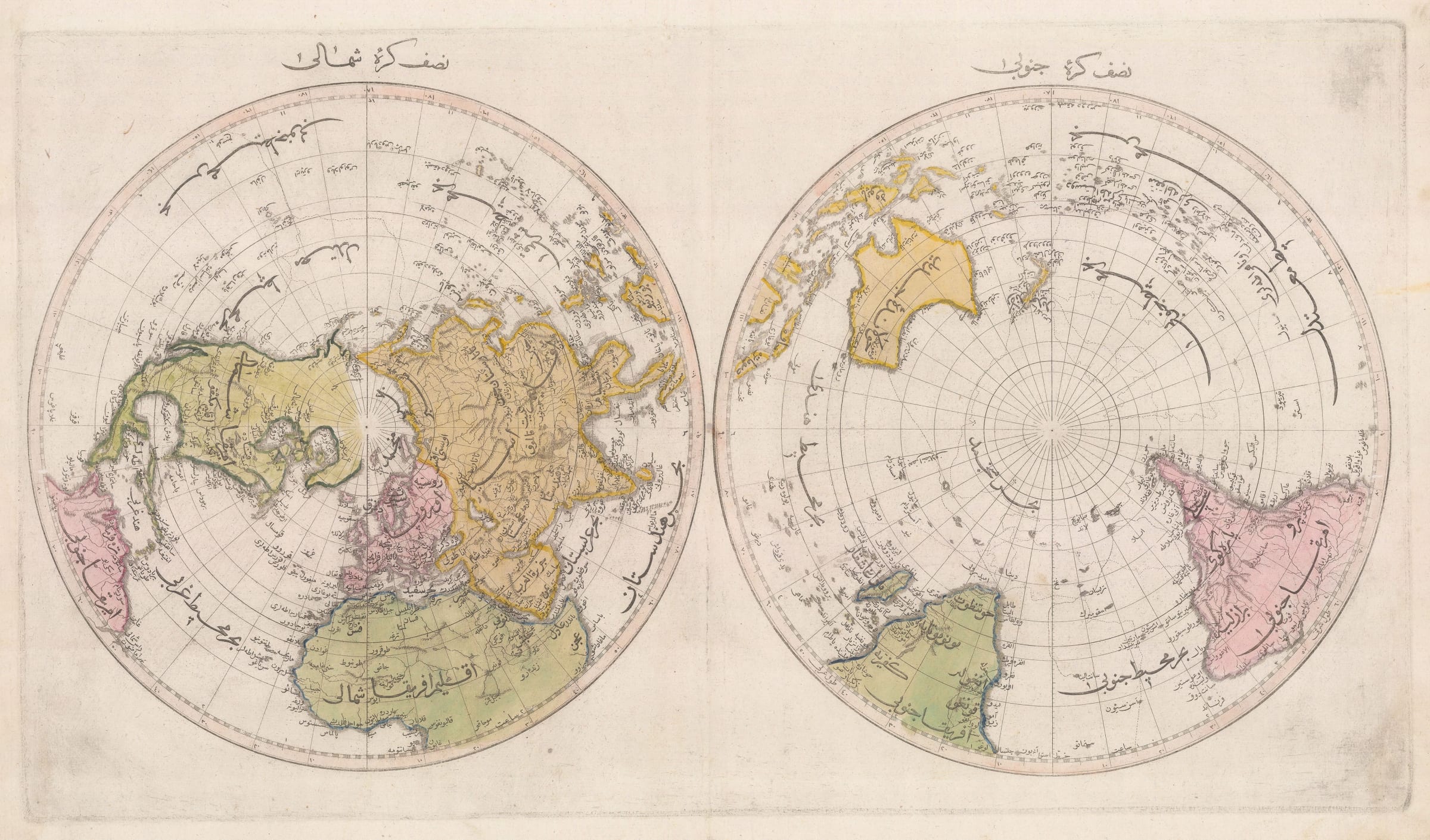
Mahmoud Raif Efendi
61 x 88.9 cm
The Cedid Atlas was compiled by Mahmoud Raif Efendi who served as Secretary to the first permanent Ottoman Embassy in London. In fact, this Embassy, established in 1793, was the first permanent embassy by the Ottoman Empire to any European country. The goals of the embassy were to strengthen diplomatic ties, collect as much European knowledge as possible, and educate a small coterie of young Turkish noblemen in the ways of the European courts. The move to establish permanent embassies was part of a much larger policy of reform, the Nazam-i Cedid (New Order), instituted by Sultan Selim III in an attempt to modernise the Turkish government during a period of perceived Ottoman decline.
As a talented young bureaucrat with powerful friends in the Ottoman court, Mahmoud Raif Efendi was the ideal candidate to serve on the ambassadorial staff to London. While he did not speak English, he did speak fluent French, the international language of diplomacy at the time, and was reportedly extremely charismatic. While in London he regularly met with the King George III and Queen Charlotte, Prime Minister William Pitt the Younger, and Foreign Secretary William Grenville. He was a frequent guest at court and attended the Queen's Drawing-room most Thursdays, as well as several royal balls. The embassy was much respected in London for which Mahmoud Raif must receive some of the credit. After returning to Istanbul in 1796, Mahmoud Raif Efendi produced the official account of the embassy written entirely in French, the first Ottoman diplomatic report ever written in a language other than Turkish.
Raif Efendi's activities in London were hardly limited to attending court or studying French. He also developed important relationships with British Army officers, some of whom he would later fight alongside during the Napoleonic Wars. Most importantly for us though was his interaction with King George III's Royal Cartographer, William Faden. All of the maps in the Cedid Atlas, with the exception of the celestial chart, were copied directly from Faden's General Atlas, a copy of which Raif Efendi purchased during his time in London. As Royal Geographer to the famously map-obsessed King George III, William Faden's maps were mostly extremely accurate and contained the most contemporary knowledge available to the British government. As such, these were the ideal maps for Raif Efendi to translate and bring back to Turkey for further study.
The atlas was translated by Yakovakı Efendi into Ottoman Turkish, engraved and printed in Istanbul. The 25 maps in the atlas were accompanied by 79 pages of text written by Raif Efendi himself. Printing in Turkey was still severely restricted, so only 50 copies of the atlas were printed. Nine of these copies were presented as gifts to important officials and to educational institutions, including one to Sultan Selim III himself. Many of the remaining copies which were due to be sold to the public were sadly destroyed in a warehouse fire during the Janissary Revolt of 1807. Mahmoud Raif Efendi was also killed during the uprising.
Original hand-colour. Framed.
[WLD4482]
- X
- Tumblr
Join our mailing list
* denotes required fields
We will process the personal data you have supplied to communicate with you in accordance with our Privacy Policy. You can unsubscribe or change your preferences at any time by clicking the link in our emails.
Contact
The Map House
54 Beauchamp Place,
London SW3 1NY,
United Kingdom
maps@themaphouse.com
+44 (0)20 7589 4325
![]()
This website uses cookies
This site uses cookies to help make it more useful to you. Please contact us to find out more about our Cookie Policy.
Join our mailing list
* denotes required fields
We will process the personal data you have supplied to communicate with you in accordance with our Privacy Policy. You can unsubscribe or change your preferences at any time by clicking the link in our emails.